
Steinsberg (Kraichgau)
| Steinsberg | ||
|---|---|---|
 Steinsberg Castle with hamlet from the south. The castle grounds take up a good part of the small plateau. |
||
| height | 333.4 m above sea level NHN | |
| location |
Baden-Wuerttemberg Rhein-Neckar-Kreis Sinsheim - Weiler |
|
| Mountains | Kraichgau (hill country) | |
| Dominance | 17.5 km → N Stüber Zentwald in the southern Kleiner Odenwald east of Waldwimmersbach | |
| Notch height | 102 m ↓ several almost the same height on the main watershed Neckar / Rhine in the area of Sulzfeld and Landshausen | |
| Coordinates | 49 ° 12 '52 " N , 8 ° 52' 39" E | |
|
||
| Type | volcanic hardling | |
| rock | Mittelkeuper , at the top Steigerwald formation ; Chimney filling nepheline basanite | |
| particularities | Steinsberg Castle on the summit | |

The Steinsberg is a mountain cone of volcanic origin near the village of Weiler , a district of the city of Sinsheim in the Rhein-Neckar district of Baden-Württemberg . The up to 333.4 m above sea level. The elevation towering above the NHN is the highest in the northern part of the hilly landscape of Kraichgau , on top of which stands Steinsberg Castle .
geography
The Steinsberg is quite central in the northern part of the Kraichgau , which here occupies the entire width between the Upper Rhine Plain in the west and the central Neckar Valley in the east, and is 333.2 m above sea level. NHN its highest elevation, but not the highest location in the entire Kraichgau. Rather, there are heights and slopes on the southern edge of the same around Pforzheim against the Black Forest that tower over it by more than 70 m.
On a smaller scale, the Steinsberg is located in the southeast loop that the Upper Elsenz strikes between its origin almost 6 km southwest of the mountain and the largest city Sinsheim am Lauf, which is a good 4 km north. That is why the entire nearby area drains into the Elsenz via streams that are not very long - via the Eppinger Hilsbach (10 km, south-south-east run), the Ittlinger Sulzgraben (5 km, east-south-east run), two shorter streams in rows (2 km and 3 km, east run ) and the Sinsheimer Ilvesbach , (7 km, northeast run). On the western edge of its upper catchment area, the major watershed between the Neckar and the Rhine runs against the Waldangelbach on the other side, about 3 km away from the Steinsberg. The next larger elevation in the vicinity is the 325 m above sea level. NN high Eichelberg about 4 km in the southwest, over which this dividing line runs.
The Steinsberg has the strongest drop towards the north to the Ilvesbach, here it drops by more than 170 m over the first 1.8 km, which is why it appears most prominent when viewed from the wide Elsenz-Aue around Sinsheim in the north. On the west side, on the other hand, the gradient is about 50 m for the first 0.4 km, but after that the terrain stretches to the west at pretty much the same height to beyond the aforementioned large watershed.
At the south and west foot of the mountain is the hamlet belonging to Sinsheim , formerly an independent municipality, characterized by agriculture and viticulture on the steep slopes of the mountain from northwest to east, on which vines are still grown today.
Origin and geology
The Steinsberg is the relic of a now extinct volcano that was active in the Palaeogene about 55 million years ago . In today's depression of the Kraichgau between the higher-lying low mountain ranges of the Odenwald in the north and the Black Forest in the south, layers of Oberkeuper and Jura , which the chimney of the active volcano had pierced, lay above the Mittelkeuper , which is now on the surface . Parts of the surrounding rock sank in the chimney, the alkaline lava mass later solidified into hard so-called nepheline basanite with few inclusions of the adjacent rock. In a narrow contact zone around the chimney influenced by heat, pressure and intrusion, the surrounding rock (protolith) was changed contact-metamorphically , resulting in volcanic (!) Breccia .
Today the layers of Oberkeuper and Jura, including the igneous rocks deposited in the area and the volcanic body, have been completely eroded, but the inclusions can be used to reconstruct the sequence of layers up to the old surface. The chimney, which is filled with erosion-resistant rock, and its contact area withstood continuous erosion better than the surrounding rock, today's frustoconical so-called volcanic hardwood emerged, the slopes of which show the red color of the lower colored marl ( Steigerwald formation ) that was pierced here .
On both sides of the Steinsberg, two long-range faults move north-northeast and thus roughly parallel to the Upper Rhine Rift Valley. The western shifts the Lower Colorful Marl in the west against the stratigraphically deeper layers of gypsum keuper and reed sandstone on the Steinsberg side, so the deep clod is on the Upper Rhine side. The eastern one is also stepped westward, here the Gipskeuper borders in the west against the Unterkeuper and Upper Muschelkalk in the east. Further to the east, two other short faults run parallel to the Elsenztal, which is moving north-north-west here; this time the Hochscholle lies on the west side of the one closer to the Steinsberg; the immediate west formed together with the failure of which Horst wedges north of soon, he is morphologically very conspicuous. At the second small fault immediately before the edge of the Elsenz valley, the eastern floe is again higher up as usual.

Geotopes on the Steinsberg
- The nepheline basanite chimney filling is on the right in front of the gate, as well as on the round tower inside the castle. Reading stones can be found in the forest on the small plateau. The breccia surrounding the chimney cannot be seen today, but it was open to construction work.
- In the hamlet of sandstone quarry near the sports field about 500 m west of the castle below 290 m above sea level. NN is exposed to the reed sandstone that forms the small plain around the small mountain cone of the Steinsberg.
- Less than a kilometer east of the castle in the Bockenhaele , just beyond the fault moving east of the mountain, there is an abandoned quarry in the Upper Muschelkalk at about 250 m above sea level. NN

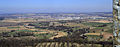
Typical distant view in Kraichgau on the Steinsberg
View from Steinsberg to the north on Sinsheim

View from the Steinsberg to the east on rows in the Elsenz valley

View from Steinsberg to the south on Weiler


Individual evidence
- ↑ Map services of the Federal Agency for Nature Conservation ( information )
- ↑ See the contour of the Kraichgau natural area at LUBW-NRG200. The highest point of the Kraichgau then on the northern slope of the mountain forest near Birkenfeld at around 405 m above sea level. NN .
- ↑ Brief outline of the geology of the Kraichgau ( LGRB ).
- ↑ LGRB-GÜK300 shows the uppermost non-volcanic layer on the mountain, the reed sandstone ( Stuttgart formation ) below , which, however, is probably due to the generalization and the rough scale.
- ↑ Geology also according to LGRB-GÜK300 and the information contained in the following geotope descriptions.
- ↑ Geotope description of the Steinsberg Steinsberg (PDF, 856 kB) at LGRB-GTP.
- ↑ Geotope description of the reed sand quarry on the west foot (PDF, 846 kB) at LGRB-GTP.
- ↑ Geotope description of the Muschelkalkbruch in the Bockenhahmen (PDF, 313 kB) at LGRB-GTP.
Web links
-
Geoportal Baden-Württemberg ( information ), especially with the partial maps / layers
- the State Institute for the Environment, Measurements and Nature Conservation Baden-Württemberg (LUBW)
- "LUBW-FG10": River 1: 10,000
- "LUBW-GEZG": water catchment areas
- "LUBW-NRG200": Natural spatial structure 1: 200,000
- of the State Office for Geology, Raw Materials and Mining of the State of Baden-Württemberg (LGRB)
- "LGRB-GTP": Geotope cadastre
- "LGRB-GÜK300": Geological overview map 1: 300,000
- the State Institute for the Environment, Measurements and Nature Conservation Baden-Württemberg (LUBW)