
Tiefenbach (Gundelsheim)
|
Tiefenbach
City of Gundelsheim
|
|
|---|---|
 |
|
| Height : | 233 m |
| Area : | 4.92 km² |
| Residents : | 632 (2014) |
| Population density : | 128 inhabitants / km² |
| Incorporation : | 1st September 1971 |
| Postal code : | 74831 |
| Area code : | 06269 |
 |
|
Tiefenbach is a village in the Heilbronn district in northern Baden-Württemberg . It has about 650 inhabitants and has belonged to the city of Gundelsheim since September 1, 1971 .
geography
Geographical location
.JPG)
.JPG)
Tiefenbach is located about 3.5 km northeast of the city center of Gundelsheim and about 17 km north of that of Heilbronn (as the crow flies ) on the northern edge of the so-called Krummen Ebene between the Neckar flowing northwards in the west at Gundelsheim and the Neckar which strives towards it in the south-east on a south-westerly course Chasing . A larger forest area called Selbach begins a little northwest of Tiefenbach . There, at the edge of the forest, about 1.7 km from the town center, there is a sinkhole, colloquially known as the deer bowl , which is the result of typical karstification phenomena in the shell limestone.

The highest point of the district is on the summit of the Dachsberg ( 304.6 m above sea level ), which rises less than 1.5 km north of the town center on the spur between the Tiefenbach and Seelbachtal in the open corridor, the deepest at the outflow of the Tiefenbach at 200– 195 m above sea level. NN . The district is mostly open, only on the northern edge and on the slopes of the Tiefenbach valley is there forest. In the local area, the natural areas of building land (at an angle from approximately southwest to northeast), Neudenauer Hügel (approximately from northeast to south-southeast) and Hohenloher and Haller level (approximately from south-southeast to southwest) meet, all are parts of the Neckar, which is characterized by the shell limestone in the subsoil. and Tauber-Gäuplatten .
The village is located in the valley basin of the Tiefenbach , which runs in the upper reaches of the eastern edge of the Selbach forest area approximately south to the Jagst , into which its short, but also clearly indented, central river Seelbach flows from the right at the edge of the forest and at an acute angle . Most of the houses in the town center are in the floodplain or on the lower slopes of the two valleys. A large newer settlement area was built a little north on the spur of the mouth of the two village streams.
To Tiefenbach - with only three house numbers - the Müssigmühle residential area almost 1.5 km southeast of the center of the village in the southeastern tip of the district belongs to.
Neighboring places
The neighboring towns are Allfeld in the municipality of Billigheim about 4 km in the northeast, Bernbrunn about 2 km in the east, Höchstberg about 2 km in the southeast and Bachenau less than 2.5 km in the south-southwest, the last three belong to Gundelsheim about 3.5 km in the Southwest.
history
The remains of a villa rustica indicate a scattered provincial Roman settlement.
Tiefenbach was first mentioned as Diepenbach in the Lorsch Codex in 773 . Since the 15th century the place belonged to the Teutonic Order . On the side of the church, Tiefenbach belonged to the Untergriesheim parish in 1553, and in 1713 the village became a branch of Höchstberg.
Because of the sandstone quarries, stone handicrafts and sculpture were common local industries. The pottery clay from the Tiefenbach clay pits was also in demand. After 1860, large amounts of building material were sent from Tiefenbach to neighboring communities and the surrounding area. Good quality lime and bricks were burned here, and sandstone from the Tiefenbach quarry, which was even used in Horneck Castle in Gundelsheim , was also in great demand .
In 1901 the old St. James' Church in the village was replaced by a larger neo-Romanesque church.
In 1939 there were 493 inhabitants, at the end of 1945 there were 548. During the Second World War , on April 2 and 3, 1945, heavy fighting between German and American units broke out in the village . A wayside shrine was erected in Allfelder Strasse to show gratitude that no Tiefenbacher was killed .
On September 1, 1971, Tiefenbach was incorporated into Gundelsheim.
The place is still dominated by agriculture and the infrastructure of the village is dwindling. Due to the lack of village trade, the population cannot get supplies locally. The next option for shopping is only in Gundelsheim, 5 kilometers away. Due to the valley location, there is no or only limited mobile network reception , especially in the center of the village, but also in other parts of Tiefenbach . Today the place is predominantly a place of residence for commuters from the surrounding cities and communities.
The village community is shaped by the local clubs, including music and sports clubs as well as the Tiefenbach youth club, the women's association and the Tiefenbach youth club.
The inhabitants of Tiefenbach have the traditional Utz name frog legs or frogs , probably based on the frog legs popular as a fasting food in Catholic areas . The design of the village fountain, which shows three frogs, goes back to this nickname.
Religions
Due to the former membership of the German Order , Tiefenbach is traditionally predominantly Catholic . Ecclesiastically, Tiefenbach originally belonged to the parish in Untergriesheim . In 1713 Höchstberg and Tiefenbach were separated from Untergriesheim and Tiefenbach became a subsidiary of Höchstberg. In 1748, the Teutonic Order Coming to Horneck Castle had the baroque St. James Church built in the center of the village instead of a dilapidated previous building. In 1875 Tiefenbach received its own parish . Between 1900 and 1902 the new parish church of St. Jakobus was built on the outskirts towards Gundelsheim. The old church building of the Teutonic Order in the center of the village was secularized and converted into a residential building.
badges and flags
The blazon of the Tiefenbach coat of arms reads: In a split shield in front in silver a continuous black cross, behind in green a silver wave bar. The municipality's flag was white and green.
Tiefenbach's patch mark, which was handed down in the Kieser Forestry Camp Book of 1684, was a D (for Diefenbach ); an old town seal or coat of arms is not known. The Tiefenbach coat of arms was proposed by the Württemberg archives in 1938, with a silver wavy bar on a black background in the rear half of the shield. The cross stands for the Teutonic Order, to which the place belonged from the late Middle Ages to 1806, the wavy bar symbolizes a brook and turns the coat of arms into a talking coat of arms . The municipality apparently only used the earlier draft in its official seal after 1948 ; The coat of arms has been used in its current form since 1957. Coat of arms and flag colors were awarded to the community of Tiefenbach on January 3, 1958 by the Baden-Württemberg Ministry of the Interior.
Attractions

- The Catholic parish church of St. Jakobus was built from 1900 to 1902 according to plans by Ulrich Pohlhammer . The church is the landmark of the place, in front of it there is a war memorial.
- The former St. James' Church in the center of the village already existed in 1604, was renovated by Franz Häffele in 1747/48 and, after the construction of the new church, converted into a residential building in 1900. While nothing on the street-side facade indicates the earlier church building, the apse of the former choir of the church has been preserved in its original form on the back of the building.
- There are also numerous historical figures of Mary and wayside shrines throughout the village, some from the 18th century, but also a younger wayside shrine from 1945.

Mayor's office

Village fountain
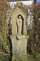
Wayside shrine from 1945

War memorial in front of the church


Personalities
- Florian Rieß SJ (1823–1882), author and publisher born in Tiefenbach, editor of the Deutsches Volksblatt and the Katholische Sonntagszeitung
Individual evidence
- ↑ Gundelsheim - detail page - LEO-BW. Retrieved April 7, 2020 .
- ↑ Geography according to: State Institute for the Environment Baden-Württemberg (LUBW) ( notes )
- ↑ Communications from the Württ. And Bad. State Statistical Office No. 1: Results of the population census on December 31, 1945 in Northern Württemberg
- ^ Federal Statistical Office (ed.): Historical municipality directory for the Federal Republic of Germany. Name, border and key number changes in municipalities, counties and administrative districts from May 27, 1970 to December 31, 1982 . W. Kohlhammer, Stuttgart / Mainz 1983, ISBN 3-17-003263-1 , p. 450 .
- ↑ Source for the section coat of arms and flag: Eberhard Gönner: Wappenbuch des Stadt- und Landkreis Heilbronn with a territorial history of this area . Archive Directorate Stuttgart, Stuttgart 1965 (Publications of the State Archive Administration Baden-Württemberg, 9). P. 142
Information brochure of the Teutonic Order City
