
Höchstberg (Gundelsheim)
|
Höchstberg
City of Gundelsheim
|
|
|---|---|
 |
|
| Height : | 240 m above sea level NN |
| Area : | 5.99 km² |
| Residents : | 814 (2014) |
| Population density : | 136 inhabitants / km² |
| Incorporation : | 1st January 1975 |
| Postal code : | 74831 |
| Area code : | 07136 |
Höchstberg is a village in Baden-Württemberg that has been part of the city of Gundelsheim since 1975 . The place is particularly known for its pilgrimage church.
history
Höchstberg was first mentioned in a document in 1305 as the immediate imperial village "Villa Hechesbur". The origin of the place name is controversial. While some sources ascribe the place to a farmer Hecho , other sources interpret the place name as fortified height . In the course of history, the name changed via Hechspur (1396) and Höchsperg (1413) to Höchstberg .
The settlement of the place took place around 1100. According to the first mention around 1300 there was a rug court on the Stahlbühl . The place belonged to different lords, including the lords of Bieringen, the Grecken of Kochendorf, the lords of Berlichingen and the Comburg monastery . From 1463 the place gradually came to the Teutonic Order , which the Coming Horneck assigned to Horneck Castle . Although the highest jurisdiction over the place was held by the Reformation -minded Count Palatine and the right of patronage from 1505 lay with the Duke of Württemberg , who was also Reformation-minded , the place remained Catholic at the time of the Reformation due to its membership of the German Order. The Teutonic Order also acquired the surrounding monastery complex and the patronage of the pilgrimage chapel by 1585.
In the Peasants 'War Höchstberg was spared in the Thirty Years' War , however, repeatedly looted and vandalized. The plague also broke out in 1635 . In 1688, the Teutonic Order acquired high jurisdiction.
In 1806 the place became part of Württemberg and was subordinate to the Neckarsulm Office . Around 1850 the community was able to buy itself out of the rights of the landlords . During and after the Second World War , the population grew strongly due to the influx of over 200 refugees and displaced persons . In 1939 there were 495 inhabitants, at the end of 1945 there were 664. In 1962 the nearby hamlet of Bernbrunn became part of the municipality of Höchstberg. In the competition Our village should become more beautiful , Höchstberg won first prize at district level in 1972 and 1974 and the state prize at state level in 1973. On January 1, 1975 Höchstberg was incorporated into Gundelsheim.
The place is still strongly agricultural today and a place of residence for commuters from the surrounding cities and communities. The declining development of the village infrastructure has already come to an end: there is nothing left of what used to be several shops and service providers.
coat of arms
From 1918 to 1938 the community stamp of Höchstberg showed a figure of Mary with a child, probably a reference to the pilgrimage in Höchstberg. In 1938 the archive management suggested for Höchstberg as well as for Obergriesheim and Untergriesheim a coat of arms with boat poles and Teutonic order cross, because there were plans to unite the three villages. Since the merger did not take place, today's talking coat of arms was introduced in 1959 : a nut twig (reference to the pilgrimage church of Our Lady in the Nussbaum ) on a mountain with a German cross.
Culture
There are several choirs and associations in the village. Among the local clubs, in addition to the gymnastics and sports club, the Paniker Club Höchstberg e. V. Mention, who in the summer of 2006 organized the nationally known Schefflenztal Open Air Rock Festival for the 20th time .
Buildings
Pilgrimage church

The pilgrimage church of Our Lady in the Nussbaum was first mentioned as a chapel in 1328 and must have been established at that time. From 1585 the Teutonic Order held the patronage, which also expanded the church in 1698. The church was destroyed by artillery fire in the last days of the Second World War on April 2, 1945, but was rebuilt by the citizens until 1958. The interior of the church, which is still a popular pilgrimage destination today, was last renovated in 2006.
Monastery on the Ilgenberg
On the nearby Ilgenberg there was a branch monastery of the Comburg monastery founded around 1136 by the lords of Nussbaum from Untergriesheim . Ownership of the monastery went to the Reformation lords of Gemmingen in 1523 , who secularized the monastery and sold it to the municipality of Höchstberg in 1853 after centuries of agricultural use. The community tore down the remaining monastery buildings, including a chapel from the 14th century and a wine press, after 1900. Only a mountain barn from 1794 has been preserved from the monastery.
Other structures
- Parsonage from 1758 at the pilgrimage church with the German cross
- Bergscheuer from 1794
- Town hall from 1837
- War memorial 1914–1918
- Virgin Mary statue in front of the pilgrimage church
- In and around Höchstberg there are several historical wayside crosses and wayside shrines, some of them from the 18th century

Rectory from 1758

town hall

War memorial

Wayside cross from 1748

Wayside cross from 1771
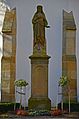
Mary statue in front of the pilgrimage church Höchstberg


swell
- Details on the local history from a presentation by Helmut Rüger at the village anniversary, September 2005
- ↑ Communications from the Württ. And Bad. State Statistical Office No. 1: Results of the population census on December 31, 1945 in Northern Württemberg
- ^ Federal Statistical Office (ed.): Historical municipality directory for the Federal Republic of Germany. Name, border and key number changes in municipalities, counties and administrative districts from May 27, 1970 to December 31, 1982 . W. Kohlhammer, Stuttgart / Mainz 1983, ISBN 3-17-003263-1 , p. 465 .
Web links
- www.hoechstberg.info - website about the pilgrimage church and the history of the place
- Höchstberg on the website of the city of Gundelsheim
