
Binau
| coat of arms | Germany map | |
|---|---|---|

|
Coordinates: 49 ° 22 ' N , 9 ° 3' E |
|
| Basic data | ||
| State : | Baden-Württemberg | |
| Administrative region : | Karlsruhe | |
| County : | Neckar-Odenwald district | |
| Height : | 253 m above sea level NHN | |
| Area : | 4.83 km 2 | |
| Residents: | 1426 (December 31, 2018) | |
| Population density : | 295 inhabitants per km 2 | |
| Postal code : | 74862 | |
| Area code : | 06263 | |
| License plate : | MOS, BCH | |
| Community key : | 08 2 25 010 | |
| LOCODE : | DE 8BK | |
| Address of the municipal administration: |
Reichenbucherstraße 38a 74862 Binau |
|
| Website : | ||
| Mayor : | Rene Friedrich (independent) | |
| Location of the community Binau in the Neckar-Odenwald district | ||
  |
||


Binau is the Neckar-Odenwald belonging municipality in Baden-Württemberg . It belongs to the European metropolitan region of Rhine-Neckar .
geography
location
Binau is embedded in an elongated loop of the Neckar between the Hohen and the Kleiner Odenwald . The municipality is located in the Neckartal-Odenwald Nature Park . Neighboring communities are (clockwise from the north) Neckargerach , Mosbach and Obrigheim , all in the Neckar-Odenwald district .
Community structure
The community of Binau includes the village of Binau and the village of Binau-Siedlung, which houses the train station and several factories.
history
Binau was first mentioned in a document in 769 , but is certainly much older. Prehistoric finds date back to the Bronze Age . With the ending -au, the place name indicates natural conditions, namely the Neckar floodplain where the place is located. It is not sure whether the meaning of the name comes from a fishing device with willow rods, the Benne or Binne, or from beekeeping. Both fish and beehives are depicted on the “talking” coat of arms of the community.
The first written mentions of the place can be found in the Lorsch Codex , where the place is mentioned a total of six times: 769 as Benenheim , 772 as Beonanheim , 774 Beninheim , and 776, 778 and 795 again as Benenheim. The fact that the place always appears in Lorsch documents with the ending -heim is attributed to the fact that place names ending in -au and -heim in southern Germany are spoken identically with the ending -a and Lorsch writers use the spoken place name as a starting point have mistakenly opted for the more frequent home , which was also the case for the following centuries. In Sebastian Münster's map from 1536 the place appears as Buenaw . The ending in -au became popular in the Amstuben from the 18th century. The place was then called Neckarbinau for about 150 years before the current spelling Binau was established around 1850 .
During the era of the tribal duchies , Binau was part of the Duchy of Franconia . Practically nothing is known about the early ownership history of the place. In the middle of the 12th century, a knight Cuno von Tahenstein donated extensive goods in Binau and Mörtelstein to Hirsau Monastery . The name of the knight refers to the Dauchstein Castle , which was built during the Staufer period and to which Binau was a hamlet. The castle was given the shape that can still be seen today in the first half of the 14th century. At that time, a family of ministers who sat there called themselves von Binau , who probably also built the church of the village with only a few farmsteads around 1350.
As a noble manor, Binau has a varied history of ownership. In 1359, Johann von Helmstatt was a descendant of the Lords of Helmstatt as a fiefdom holder on Dauchstein. In the 15th century a Dieter Rüdt von Bödigheim acquired the Dauchstein Castle and built a castle in the village, after which the castle began to fall into disrepair. In the castle, which was renovated to its present form in 1742–44, the other local lords of Binau lived until the end of the imperial knighthood: the Landschad von Steinach , the Vögte von Hunolstein , the Ritterrat Friedrich Leropold von Adelsheim (builder of the new building 1742/44), the Counts of Riaucour and from Waldkirch . Especially during the time under Count Andreas von Riaucour (1721–1794), who owned Binau from 1767, courtly splendor shone in the castle, which was primarily used for representation.
In 1764, the Binau manor comprised castle, manor, hunter and sheep houses, noble properties of 123 acres of fields, 47 acres of meadows, 8 acres of herb and orchards, 4 acres of vineyards and 650 acres of forest. The estate was leased to mostly Mennonite tenants until the second half of the 19th century .
With the dissolution of the imperial knighthood from 1802 Binau came to Baden. The free aristocratic owners, the Counts of Waldkirch, became Baden Chamberlain. Countess Marianne von Waldkrich-Riaucour († 1811) determined in her will that the Binau estate should never be sold, but a few decades after her death, the parceling and the successive sale of the former manor began. The castle building came to the Göler von Ravensburg through the marriage of a descendant . Baron Louis von Göler († 1894) was the last noble lord of the castle. He did a great job of singing in the Neckar Valley and moved to Karlsruhe in 1891.
In 1897, the Mannheim factory owner and councilor Heinrich Propfe acquired the palace and had it extensively renovated for residential purposes. Propfe had far-reaching plans to transform Binau into an industrial town in order to create a new source of income for the village population, who until then had lived almost entirely on agriculture. Propfe had facilities built for the production of explosives ( cheddit ) and water glass as well as for charring . The production of explosives and water glass was never taken up, but wood charring, wood saccharification and wood distillation for the production of tannin took off. In 1903 a brewery and a slaughterhouse were built for the newly started pig breeding. In addition, Propfe dealt with the breeding of new crops. Propfe died in 1913, his son died shortly afterwards in the First World War. None of the family's ventures survived. Propfe's grandsons, who experimented promisingly with crop protection and freeze-drying in the Neckar Valley, had a similar fate when they fell in World War II and their companies went under.
In 1939 there were 363 inhabitants, at the end of 1945 there were 464. During the Second World War, the castle was the seat of the SS headquarters of the subcamps of the Natzweiler-Struthof concentration camp, which had been distributed throughout the region since autumn 1944 . Industrial companies were to be relocated here in tunnels for underground production (camouflage name Goldfisch GmbH ).
Binau has been part of the Mosbach district since the transition to Baden until it was merged into the new Neckar-Odenwald district in 1973.
Religions
A Jewish community existed in Binau from the 17th or the beginning of the 18th century until 1940. The highest number of Jewish residents was reached around 1839 with 146 people, more than a third of the total population of the place at that time. Until after 1933, a butcher's shop and a manufactured goods store were owned by Jewish families. After the deportations in October 1940, at least 11 of the 20 Jewish residents still living here in 1933 were killed.
politics

Municipal council
The municipality council has 10 honorary members who are elected for five years. In addition, the mayor acts as the municipal council chairman with voting rights.
The 2019 local elections led to the following result (in brackets: difference to 2014):
| Municipal Council 2019 | ||||
|---|---|---|---|---|
| Party / list | Share of votes | Seats | ||
| Independent Binau Voting Association (UBW) | 47.4% (−3.2) | 5 (± 0) | ||
| Free Citizens List (FBL) | 29.8% (+29.8) | 3 (+3) | ||
| SPD | 22.9% (−3.3) | 2 (−1) | ||
| Turnout: 64.4% (+3.6) | ||||
Administrative association
Together with the municipalities of Neckargerach , Waldbrunn and Zwingenberg , Binau is a member of the municipal administration association “Neckargerach-Waldbrunn”.
mayor
- 1835–1839: Johann Adam Bender
- 1839–1848: Adam Groskopf
- 1848–1860: Johann Georg Dollinger the Elder Ä.
- 1860–1868: Johann Georg Seppich
- 1868–1873: Johann Georg Dollinger d. J.
- 1873–1879: Karl Großkopf
- 1879–1910: Johann Georg Dollinger the Elder J.
- 1910–1931: Wilhelm Brand
- 1931–1945: Wilhelm Pfisterer
- 1945–1946: Max Großkopf
- 1946–1954: Ernst Dollinger
- 1954–1986: Ludwig Pfisterer
- 1986–2018: Peter Keller
- since February 1, 2018: René Friedrich
Partnerships
The community maintains a partnership with Lindau im Eichsfeld .
coat of arms
Two golden (yellow) beehives next to each other in a split shield above in blue, below a blue fish in silver (white).
The coat of arms symbolizes with the beehives "talking" the place name and with the fish the location of the community on the Neckar and the Neckar fishing. The coat of arms was awarded to the municipality on November 5, 1957.
Culture and sights


- Dauchstein Castle is the ruin of a medieval castle on the banks of the Neckar outside the village.
- Binau Castle is located in the center of the village, only a few meters above the Neckar river. The castle, built in 1742 instead of a previous building, was inhabited by changing noble owners until 1891 and then by the Propfe family. From September 1944 the administration and the effects roomof the Natzweiler-Struthof concentration camp were housed there. After the Second World War, the building temporarily served as a hotel guesthouse, and since 1963it has housedan old people's and nursing home .
- In the old town center, next to the castle, there is also the Evangelical Church , which dates back to the Middle Ages and which received its present form through renovation in 1783. In the tower choir of the church, historical wall paintings from the 14th century were uncovered in the 1920s, including in particular the choir vault with the four evangelist symbols . Historical grave slabs of the Lords of Bödigheim from the 16th century are also embedded in the choir walls.
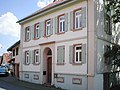
- Numerous historical half-timbered houses have been preserved in Binau . The cellar of one of the oldest half-timbered buildings near the castle dates back to 1569.
- The community's Jewish cemetery was laid out in 1851 on Reichenbucher Strasse (100 m west of the general cemetery) (parcel 972, area 7.74 acres). It was in 1944 to the cemetery of the concentration camp Neckarelz and the satellite camp Neckargerach converted. Over 200 dead from the armaments factory near Obrigheim were buried there from October 1944 to March 1945. Today a memorial stone in the Jewish cemetery commemorates the perished prisoners and forced laborers from several European countries from the Neckarelz camp and its sub-units.
- Half of the Neckar barrage Guttenbach lies within the Binaus district.
Historical building

Half-timbered building with cellar from 1569

Jewish Cemetery


Economy and Infrastructure

traffic
Binau is located on the " Neckar Valley Railway " ( Heidelberg - Bad Friedrichshall ), which has been served every half hour by the RheinNeckar S-Bahn since 2003 . There are also bus connections to Mosbach / Eberbach . The town is separated from the river by the main road running along the bank.
Educational institutions
Binau has a primary school . Secondary schools can be attended in the neighboring towns.
Leisure and sports facilities
- Campsite (Fortuna Camping) Binau
- Sports field of FC Binau 1927
- Schützenverein Binau
literature
- Ernst Brauch: Binau - a gem on the Neckar. Private print by the Binau community, 1969
Web links
Individual evidence
- ↑ State Statistical Office Baden-Württemberg - Population by nationality and gender on December 31, 2018 (CSV file) ( help on this ).
- ^ The state of Baden-Württemberg. Official description by district and municipality. Volume V: Karlsruhe District Kohlhammer, Stuttgart 1976, ISBN 3-17-002542-2 . Pp. 306-307
- ↑ Brauch 1969, pp. 53-56.
- ↑ Communications from the Württ. And Bad. State Statistical Office No. 2: Results of the population census on December 31, 1945 in North Baden
- ^ State Statistical Office of Baden-Württemberg: Municipal elections 2019, Binau ; Rhein-Neckar-Zeitung , May 27, 2019: This is Binau's new municipal council .
- ↑ "René Friedrich wins over 64 percent in the first ballot" in the Rhein-Neckar-Zeitung December 4, 2017
- ↑ Memorial sites for the victims of National Socialism. A documentation, Volume I, Bonn 1995, p. 25, ISBN 3-89331-208-0
- ↑ Ludwig Schmieder: The wall paintings of the church in Binau aN in: Mein Heimatland, Badische Blätter für Volkskunde , Karlsruhe 1928 ( online )

Adelsheim | Aglasterhausen | Cheap home | Binau | Book | Elztal | Fahrbach | Hardheim | Hassmersheim | Höpfingen | Hüffenhardt | Limbach | Mosbach | Mudau | Neckargerach | Neckarzimmern | Neunkirchen | Obrigheim | Osterburken | Ravenstein | Rosenberg | Schefflenz | Schwarzach | Seckach | Waldbrunn | Walldürn | Zwingenberg