
Obrigheim (Baden)
| coat of arms | Germany map | |
|---|---|---|
_COA.svg)
|
Coordinates: 49 ° 21 ' N , 9 ° 6' E |
|
| Basic data | ||
| State : | Baden-Württemberg | |
| Administrative region : | Karlsruhe | |
| County : | Neckar-Odenwald district | |
| Height : | 147 m above sea level NHN | |
| Area : | 24.27 km 2 | |
| Residents: | 5307 (Dec. 31, 2018) | |
| Population density : | 219 inhabitants per km 2 | |
| Postal code : | 74847 | |
| Primaries : | 06261, 06262 | |
| License plate : | MOS, BCH | |
| Community key : | 08 2 25 074 | |
| LOCODE : | DE OGH | |
| Community structure: | 3 districts | |
| Address of the municipal administration: |
Hauptstrasse 7 74847 Obrigheim |
|
| Website : | ||
| Mayor : | Achim Walter ( FDP ) | |
| Location of the community of Obrigheim in the Neckar-Odenwald district | ||
  |
||

Obrigheim is a municipality in the Neckar-Odenwald district in Baden-Württemberg . It belongs to the European metropolitan region of Rhine-Neckar (until May 20, 2003 the Lower Neckar region and until December 31, 2005 the Rhine-Neckar-Odenwald region ).
geography
Geographical location
The community of Obrigheim is located on the Burgenstrasse at the foothills of the Odenwald on the west bank of the Neckar directly opposite the Mosbach district of Diedesheim, around 50 kilometers east of Heidelberg and around 30 kilometers north of Heilbronn . The municipality is located in the Neckartal-Odenwald nature park between 138 and 323 meters above sea level.

Community structure
The former communities Asbach and Mörtelstein belong to the community of Obrigheim . The village of Asbach and the Asbach train station belong to the former community of Asbach. The village of Mörtelstein and the Neckarhelde house belong to the former municipality of Mörtelstein. The village of Obrigheim, the village of Neuburg and the homestead Kirstetterhof belong to the municipality of Obrigheim in the 1970s.
The Schollenrain desert is located in the area of the former municipality of Mörtelstein .
history
First settlement
Various finds from the Neolithic Age and the time of the band ceramics point to a very early settlement in what is now the municipality of Obrigheim. Stone and Bronze Age graves were also discovered. Skeletal graves and grave goods from Celtic times were found in Obrigheim. The Romans talked about which a settlement in Obrigheim Neckar limes secure and Neckar and border crossing (probably a Ford , because there is no bridge could be detected) monitor. The foundations of a Villa Rustica near Kälbertshausen and the Merkur stone excavated in the center of the village have been preserved from Roman times . As in all of Southwest Germany on the right bank of the Rhine, the Romans were expelled by the Alemanni in the 3rd century , followed by the Franks in the 6th century .
First mention
In 773 the Lorsch Codex mentioned the donation of a certain Reginhard von Gütern in Ubracheim to the Lorsch Monastery . Obrigheim was mentioned again in 976 in connection with the award of Mosbach Abbey to Worms by Emperor Otto II . The Mörtelstein district was first mentioned around the year 1000, that of the Asbach district around 1100.
middle Ages
In the Middle Ages there were three castles in Obrigheim. The oldest castle in the village was Obrigheim Castle in the center of the village on the hill near today's Protestant church, which first appeared in the documents as early as 1142. It was probably founded by the noble noble family of the Lords of Obrigheim, which has been documented since 1082. In the 13th century, the complex was then owned by a family of ministers of the same name, who were related to the Pfalz Wimpfen . In the course of the 14th century the castle was acquired bit by bit by the Rhineland Count Palatine. In 1369 , Count Palatine Ruprecht I acquired the shares of Cuntze von Obrigheim in the "old castle". At the end of the 13th century, the Count Palatine near Rhine had built another castle on the Karlsberg upstream of the Neckar, which at times was called Burg Landsehr . As early as 1290 there was an Electoral Palatinate office in Obrigheim, which was later moved to the temple house in Neckarelz on the other bank of the Neckar. The facility on the Karlsberg was probably given up again in the middle of the 14th century.
The youngest castle in the area is probably Neuburg Castle , which does not appear in the sources until 1384 and was hardly built before the middle of the 14th century. After the Palatinate partition in 1410, the "old castle" was still the residence of a Palatinate-Mosbach feudal man for a time. It was probably given up at the turn of the 15th to the 16th century and its area was later partially built over. In the following three centuries, however, the Neuburg was repeatedly given to fiefdoms from Palatine vassal families. In the 16th century the Lords of Rossau had the Neuburg as a fief and partially redesigned it. The castle is still the landmark of the place that can be seen from afar. Churches have been documented in Obrigheim and Mörtelstein since 1371.
Thirty Years' War
In the Thirty Years War , Obrigheim was practically wiped out in 1635. The continued existence of the place is only owed to the settlement of mostly Swiss immigrants by the Count Palatine. During the war, the feudal lord of Neuburg was the electoral Bavarian chancellor Georg Friedrich von Iselbach. The place, which was not spared from wars and epidemics, was to be characterized by poverty and great misery for over 200 years after the Thirty Years' War.
18th and 19th centuries
In 1786 there were three churches, a school and 118 houses in the village of Obrigheim. During the coalition wars there was a battle near Obrigheim on November 4, 1799 , during which Carl Philipp von Wrede, who occupied the right bank of the Neckar near Diedesheim and Neckarelz, took Obrigheim with his troops, which had been occupied by around 500 French.
In 1803 the place came to the principality of Leiningen , 1806 transition to the newly created Grand Duchy of Baden . The misery of the inhabitants causes a wave of emigration, mainly to America. In 1845, Count Carl von Leiningen-Billigheim acquired Neuburg Castle. He had the castle rebuilt in the style of castle romanticism and gave it its current appearance. In 1862 the Odenwaldbahn was built via Obrigheim. A train station was not set up until 1891.
In the 19th century the first industrial companies settled in Obrigheim. From 1847 there was a gypsum mine. In 1888 the "Gebrüder Dörflinger" axle and spring factory from Mannheim set up a branch in the town. In 1900 many residents of the village were already employed in industry. The spring factory had 47 and the gypsum quarry 21 employees. At that time, 66 people from Obrigheim worked in Diedesheim and Neckarelz , where there was a cement works and two iron foundries.
Period of National Socialism and World War II 1933–1945
In 1935, Neuburg Castle became a district training castle for the NSDAP. In 1939 there were 1,197 inhabitants, at the end of 1945 there were 1,367.
From 1944 to 1945 there was a satellite camp of the Natzweiler-Struthof concentration camp in Neckarelz . The prisoners carved production rooms in the Obrigheim gypsum tunnel. They were initially trapped in the school in the Mosbach- Neckarelz district on the opposite side of the Neckar . The camp complex grew rapidly. Almost 10,000 people worked in the underground bomber aircraft engine factory in Obrigheim, many of them prisoners of various kinds. Among them the 5,000 concentration camp prisoners formed the main group. 900 were liberated in April 1945. The railway connections and the nearby armaments factories were the cause of several air raids during the war.
present
After the war, displaced persons were housed in Neuburg Castle. In 1961 the municipality was chosen as the location of the first commercially used nuclear power plant in Germany. The establishment of the Kernkraftwerk Obrigheim GmbH (KWO) with a share capital of 100 million DM set important economic impulses in the region from 1964, but was also controversial. The power plant was also one of the first to be shut down in 2005. As a replacement, the community set up the Obrigheim biomass cogeneration plant (BKWO) on a directly adjacent site . Since January 2009 this has generated a thermal output of approx. 22.5 MW and an electrical output of around 6,470 kW. In the meantime (as of 2019) the BKWO is running normally.
Incorporations
-
 January 1, 1971: mortar stone
-
 January 1, 1973: Asbach
Religions
Obrigheim has been predominantly evangelical since the Reformation . In addition to the three Protestant parishes, there is also a Roman Catholic parish in the village today .
politics
Municipal council
The parish council typically has 18 honorary members who are elected for five years. Often the number of members increases through compensatory seats (total 2019: 19 seats; 2014: 20). In addition, the mayor acts as the municipal council chairman with voting rights.
The Unechte Teilorteschahl guarantees the districts a fixed number of seats: at least twelve from Obrigheim, at least four from Asbach, and at least two from Mörtelstein.
The 2019 local elections led to the following result (in brackets: difference to 2014):
| Municipal Council 2019 | ||||
|---|---|---|---|---|
| Party / list | Share of votes | Seats | ||
| FW Obrigheim | 49.2% (−1.2) | 9 (−1) | ||
| CDU / BL | 37.3% (+3.9) | 7 (± 0) | ||
| SPD | 13.5% (−2.7) | 3 (± 0) | ||
| Turnout: 59.0% (+6.0) | ||||
mayor
In October 2014, Achim Walter (FDP) was elected the new mayor with 83.24 percent of the vote. Incumbent Roland Lauer (CDU) did not run after 24 years.
coat of arms
The blazon of the coat of arms reads: By an ascending, curved red point, in which a narrow silver (white) göpel tapering into three adjacent spheres (1: 2); in front of blue and silver (white) roughened obliquely to the left, behind in black a red armored and red-tongued golden (yellow) lion.
Since the 18th century, the Palatine heraldic emblems, diamonds and lions, have been used in the seals next to Obrigheim's indistinguishable stain sign, whereby the stain sign is represented either as in the municipal coat of arms or vice versa, as a narrow drawbar growing out of a mountain of three.
Community partnerships
Obrigheim maintains partnerships with
Culture and sights


As part of the Geopark project:
- Goldfish trail of the Neckarelz concentration camp memorial , history trail to the "Goldfisch" and "Brasse" tunnels
- Gipslehrpfad - The gypsum mine between Obrigheim and Hochhausen is the largest and oldest underground gypsum mine in Germany (since 1850).
Museums
- Local history museum Obrigheim
Buildings
- Neuburg Castle , the town's landmark, is located above Obrigheim high above the Neckar and is surrounded by a moat. The property, which has been used as a hotel and restaurant since 1959, has been privately owned again since August 2007 after various changes of ownership, and in November of the same year gastronomic use was resumed.
- The Evangelical Church of Peace towers over the center of the village on the hill called Alter Berg . The old castle , from which stones have been preserved in the retaining walls by the church, was once located directly by the church .
- Landsehr Castle , located south of the town on a foothill of the Karlsberg, is only known from the topography of the area with a ditch. At the site of the former castle there is now a viewing pavilion.
- The Catholic Church of St. Laurentius was built in the Weinbrenner style in 1832 by Johann Ludwig Weinbrenner , a nephew of the namesake of the Baden classicism , Friedrich Weinbrenner .
- The war memorial of Obrigheim consists of several memorials, in addition to memorials for the fallen soldiers of the First and Second World War, also a memorial for the participants in the Franco-German War 1870/71 with a list of participants and a portrait of the Grand Duke of Baden.

Neuburg Castle
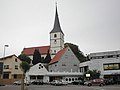
Evang. Friedenskirche
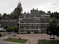
town hall

War memorial


- In the Asbach district there is the evangelical church , which presumably dates back to a medieval building, as well as a catholic church from 1890. The schoolhouse from 1839 and a boundary stone from 1558 are also worth seeing. In the district of Mörtelstein is the St. George's Chapel, renovated in 1819, with frescoes from the 15th century. Also worth mentioning there are the ornate half-timbered town hall from 1801 and the village fountain from 1899. In the wooded slopes between Mörtelstein and Obrigheim, historic vineyard terraces with stairs and shaped stones from the viticulture that was practiced here from the early 15th century and abandoned before 1770 are closed detect.
- 169 meter high meteorological measuring mast between Asbach and Kirstätter Hof at 49 ° 20'30 "north latitude and 009 ° 02'47" east longitude (demolished in 2001 by blasting). The measuring mast was part of the nuclear power plant .

Asbach schoolhouse

Ev. Asbach Church

Asbach boundary stone

Town hall mortar stone


Sports
The weightlifters of SV Germania Obrigheim fight in the 1st Bundesliga. In 2003, 2008 and 2013 the German team championship could be won. In 2005, 2007, 2010 and 2012 the runner-up was won. There is also SV Mörtelstein with the football, table tennis and women's gymnastics departments and FC Asbach.
Economy and Infrastructure

A plaster of paris loading point on the Neckar east of O., at which 300,000 tons of plaster are loaded onto barges every year.
With the TECH · N · O - Technologiepark Neckar-Odenwald , Obrigheim offers very conveniently located new company locations.
Nuclear power plant
The reactor of the Obrigheim nuclear power plant (KWO) (pressurized water reactor, 357 MW) was decommissioned on May 11, 2005, and the complex dismantling is expected to take around 14 years. The power plant is located in the district of Mörtelstein.
traffic
A two-lane modern concrete bridge leads from Obrigheim over the Neckar to Diedesheim, a district of Mosbach . The federal road 292 leads from Mosbacher Kreuz through Obrigheim towards Sinsheim .
The Meckesheim – Neckarelz railway line , which once led through Obrigheim and further over a bridge to Neckarelz to the Neckar Valley Railway that was blown up in 1945 , has been closed in this section.
Educational institutions
Obrigheim has a secondary school and a primary and secondary school . There are two Protestant and one Roman Catholic kindergartens for the youngest residents .
literature
- Karl Wilhelm Bödecker: Ortsfamilienbuch Obrigheim. People and families in Obrigheim am Neckar, 1650–1915. Plaidt: Cardamina-Verlag 2014 (= Badische Ortssippenbücher 162)
Individual evidence
- ↑ State Statistical Office Baden-Württemberg - Population by nationality and gender on December 31, 2018 (CSV file) ( help on this ).
- ^ The state of Baden-Württemberg. Official description by district and municipality. Volume V: Karlsruhe District Kohlhammer, Stuttgart 1976, ISBN 3-17-002542-2 . Pp. 299-301
- ↑ Minst, Karl Josef [transl.]: Lorscher Codex (Volume 4), Certificate 2614 July 27, 773 - Reg. 935. In: Heidelberger historical stocks - digital. Heidelberg University Library, p. 184 , accessed on April 11, 2015 .
- ↑ Communications from the Württ. And Bad. State Statistical Office No. 2: Results of the population census on December 31, 1945 in North Baden
- ↑ a b Federal Statistical Office (ed.): Historical municipality register for the Federal Republic of Germany. Name, border and key number changes in municipalities, counties and administrative districts from May 27, 1970 to December 31, 1982 . W. Kohlhammer, Stuttgart / Mainz 1983, ISBN 3-17-003263-1 , p. 477 .
- ^ Community of Obrigheim: main statute, §9 ; accessed June 22, 2019.
- ^ State Statistical Office of Baden-Württemberg: Municipal elections 2019, Obrigheim ; Municipality of Obrigheim: municipal council election 2019 (PDF) ; accessed June 22, 2019.
- ↑ https://www.nokzeit.de/2014/10/26/achim-walter-wird-buergermeister-in-obrigheim/
Web links
- Official homepage of the community of Obrigheim
- The Obrigheimer Kirche on a private website

Adelsheim | Aglasterhausen | Cheap home | Binau | Book | Elztal | Fahrbach | Hardheim | Hassmersheim | Höpfingen | Hüffenhardt | Limbach | Mosbach | Mudau | Neckargerach | Neckarzimmern | Neunkirchen | Obrigheim | Osterburken | Ravenstein | Rosenberg | Schefflenz | Schwarzach | Seckach | Waldbrunn | Walldürn | Zwingenberg