
Noble home
| coat of arms | Germany map | |
|---|---|---|

|
Coordinates: 49 ° 24 ' N , 9 ° 23' E |
|
| Basic data | ||
| State : | Baden-Württemberg | |
| Administrative region : | Karlsruhe | |
| County : | Neckar-Odenwald district | |
| Height : | 226 m above sea level NHN | |
| Area : | 43.84 km 2 | |
| Residents: | 4973 (Dec. 31, 2018) | |
| Population density : | 113 inhabitants per km 2 | |
| Postal code : | 74740 | |
| Area code : | 06291 | |
| License plate : | MOS, BCH | |
| Community key : | 08 2 25 001 | |
| LOCODE : | DE ADH | |
City administration address : |
Marktstrasse 7 74740 Adelsheim |
|
| Website : | ||
| Mayor : | Wolfram Walafried Bernhardt | |
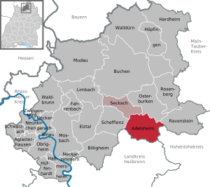
| Location of the city of Adelsheim in the Neckar-Odenwald district | ||
  |
||

Adelsheim ( ) is a small town in the Neckar-Odenwald district in the north of Baden-Württemberg, around 40 kilometers north of Heilbronn . It belongs to the European metropolitan region of Rhine-Neckar (until May 20, 2003 the Lower Neckar region and until December 31, 2005 the Rhine-Neckar-Odenwald region ). The state-approved resort has a history of over 1200 years.
geography
location
Adelsheim lies at the confluence of the Kirnau , which comes from the east, into the Seckach, which flows from the north . The confluence was used in the construction of a city fortification. The Seckach flows downstream at Möckmühl into the Jagst .
The area around Adelsheim is largely part of the building land , a ridge that leads from the Odenwald in the northwest to the Jagsttal in the south and the Taubertal in the east. The municipality is located in the Neckartal-Odenwald Nature Park and in the Bergstrasse-Odenwald Geo-Nature Park .
Adelsheim is surrounded by the neighboring communities of Osterburken in the north, Ravenstein in the northeast, Schöntal and Widdern in the southeast, Möckmühl in the south, Roigheim in the southwest, Schefflenz in the west and Seckach in the northwest.
City structure
The districts of Adelsheim, Leibenstadt and Sennfeld belong to Adelsheim .
The Adelsheim district includes the city of Adelsheim, the hamlets Hergenstadt and Wemmershof and the Dambergerhof and Seehof farms. Only the village of Leibenstadt belongs to the Leibenstadt district. The Sennfeld district includes the village of Sennfeld, the village of Roßbrunnerhof and the Talmühle residential area.
Adelsheim's core city lies in a basin formed by Seckach and Kirnau. The core city emerged from the quarter around the Protestant town church and the two castle buildings, the seaside town below the town hall and the suburb near the Gothic St. James' Church. The main street in Adelsheim is Marktstraße, from which the Obere Austraße , Rietstraße , Lachenstraße and today's federal highway 292 branch off to Oberschefflenz . It is typical of the local structure that first streets and settlements (post-war period) emerged in the various valleys and only then on the plateaus in between (1970–1990s). In the middle is the Kirnau waterfall just before it flows into the Seckach and supplies an operating mill with its energy.
history

The place, which was mentioned for the first time in a donation to the Fulda monastery under the name Adaloltesheim in 779 , came under the rule of the Lords of Dürn after several changes of ownership in the middle of the 13th century . Around this time a local nobility appeared, the lords of Adelsheim , whose fortress was mentioned in 1338. They surrounded the place with a defensive wall, which was a prerequisite for city rights. In 1374, Emperor Karl IV granted the Lords of Adelsheim city rights for their residence “through loyal service for the sake of the empire” and thus the right to fortify the place with city walls and towers. From around 1400 on, Adelsheim was a suburb of the Franconian knight canton of Odenwald . The lords of Adelsheim had their castle converted into a moated castle between Kirnau and Seckach.
In the witch hunts from 1593 to 1595, eight cases of witchcraft and sorcery are documented. Six people from Adelsheim were executed in the witch trials .
During the Thirty Years' War , Adelsheim suffered from sieges, drafts and billeting. In 1634 the residents fled the city into the surrounding forests for three weeks. In the course of the war, epidemics and famine claimed numerous other victims. Adelsheim was not spared from later wars either: in 1683 a little Adelsheim ensign fought in the relief of Vienna against the Turks in the Battle of Kahlenberg , in 1814/15 Adelsheim was a stage place during the Napoleonic Wars due to its location on the old Sachsenstrasse (Leipzig-Speyer) russian army.
On December 3, 1858, the Baden population census counted 1,341 inhabitants, of which 1,228 were Protestants, 64 Catholics and 49 "Israelites". The plus since 1855 was 11 inhabitants.
Adelsheim never belonged to the large church or secular principalities in the area, but was owned by the imperial knights until the Reichsdeputationshauptschluss 1803. Then it came to the Grand Duchy of Baden , where in 1828 it became the seat of a district office for the area of the southern building land . The Oberamtmann and the office were responsible for 34 communities, farms and hamlets with around 14,000 inhabitants. In 1936 the district was abolished and added to the Buchen district office, which in 1938 became the Buchen district .
The forerunners of the Volksfest were the Heimattage in 1948. The occasion for the second Adelsheimer Volksfest in 1949 was the inauguration ceremony of the Kirnau Bridge, which was destroyed in 1945. On November 11, 1948, the Adelsheim District Agriculture School opened its doors under the direction of Leopold Wiswesser. In the following years, too, Adelsheim's history was largely defined by its schools: the primary school moved to the Eckenberg in 1958. A few years later the grammar school with boarding school was established there . After the Buchen administrative district was dissolved, Adelsheim became part of the newly formed Neckar-Odenwald district in 1973 .
On November 1, 1971, Leibenstadt was incorporated into Adelsheim. The present city was formed on January 1st, 1975 by the union of Adelsheim with the municipality of Sennfeld.
Religions
The Jewish community of Adelsheim dates back to the 14th century. The emergence of an actual community is assumed to be in the 17th century. The highest number of Jewish residents was reached around 1885 with 70 people.
After determination of 1690 the former had Jewish community to pay to the barons year four guilders for permission on Shabbos to be allowed to keep "school", that is worship. The prayer room at that time is said to have been set up on the second floor of the house built by Melchior Keller in 1418 in Torgasse. This was canceled in 1952. Later there was a prayer room in a building that also no longer existed in the courtyard of the upper castle. A synagogue existed from the middle of the 19th century until 1889 . A mikveh (ritual immersion bath) and a cheder (Jewish school) were housed in the building of the old synagogue in the 19th century, and in the new synagogue from 1889. When this new synagogue was demolished in 1977, the mikveh was rediscovered. Burials were carried out at the Bödigheim Jewish cemetery and, after 1884, at the Sennfeld Jewish cemetery . After Wagner Bürckel action in the era of National Socialism at least ten came from the 35 Jews who had in 1933 been resident here killed.
As a result of the Reformation , the predominantly Christian population became Protestant. Until 2000 Adelsheim was the seat of a deanery (church district) of the Baden regional church with a local patronage constitution. As part of the reform of the deanery, the deanery moved to Hirschlanden (district of Rosenberg ).
Catholics formed another minority until 1930. After 1945 the refugee admission resulted in an approximate balance between the two Christian denominations. In 1960 a modern Catholic church building, the St. Mary's Church, was built next to the historic St. Jacob's Church. Both denominations run kindergartens.
politics

Municipal council
The parish council usually has 15 honorary members who are elected for five years. The municipal councils use the designation city council. Often the number of members increases through compensatory seats (total 2019: 16 seats; 2014: 19). In addition, the mayor acts as the municipal council chairman with voting rights.
The Unechte Teilorteschahl guarantees the districts a fixed number of seats: At least nine municipal councils come from Adelsheim, at least four from Sennfeld, and at least two from Leibenstadt.
The 2019 local elections , in which the SPD suffered the greatest losses, led to the following result (in brackets: difference to 2014):
| Municipal Council 2019 | ||||
|---|---|---|---|---|
| Party / list | Share of votes | Seats | ||
| CDU | 36.7% (−0.2) | 6 (−1) | ||
| SPD | 25.3% (−3.6) | 4 (−1) | ||
| FW | 22.8% (+1.7) | 4 (± 0) | ||
| Citizen List | 15.3% (+2.2) | 2 (−1) | ||
| Turnout: 58.5% (+7.9) | ||||
Mayor (post-war period)
- 1945–1948: Karl Huss
- 1948–1973: Friedrich Gerner
- 1973–1983: Günter Bauer
- 1983–1999: Peter Hütt
- 1999–2003: Walter Muth
- 2003–2019: Klaus Gramlich
- Since September 1, 2019: Wolfram Walafried Bernhardt
badges and flags
|
|
Blazon : “A black, upright ibex horn on silver. It runs from bottom to heraldic right and above (is therefore open to heraldic left). " |
| Foundation of the coat of arms: The coat of arms of the local aristocracy and today of the city was confirmed in 1422 by Emperor Sigismund . The Adelsheim city colors are black and white. The city colors can be seen by the sign man near the center on the upper castle bay window. |
Town twinning
A partnership has existed with Berchères-sur-Vesgre in France since 2011.
Culture and sights
Buildings and cultural monuments


- The Gothic Jakobskirche was built as a foundation by the Kurmainzer bailiff Martin von Adelsheim († 1497) in 1489 instead of a Romanesque predecessor structure. The church was a Protestant parish church from 1556 to 1776, and also part of the St. James pilgrimage and burial place of the Lords of Adelsheim. Today the building is used as a cemetery chapel. Over 60 historical epitaphs have been preserved on the inner and outer walls , the hill on the north side of the church is a plague grave from 1635, in which around 300 dead are said to be buried.
- The upper castle was built in 1504 next to a moated castle that had existed since the 14th century as the second castle of the Lords of Adelsheim.
- The lower castle was built as a baroque country castle under Friedrich Leopold von Adelsheim (1691 to 1763) by the master builder Johann Jakob Rischer from 1734 to 1738 in place of the moated castle destroyed by fire in 1733 . The historic rent office of the Lords of Adelsheim is also located in the castle park. The former stately tithe barn is now used as a building land museum.
- The town hall was originally built in 1619 as an inn in the Franconian half-timbered style with protruding floors. The building has been the town hall since 1839 and was also a school building until 1871, before an adjoining school building was built. The town hall was extensively renovated from 1999 to 2001 and an extension was added in place of the previous school building.
- The Evangelical City Church was built in 1766/67 in the late Baroque style instead of a Gothic chapel by the Öhringen master builder Georg Peter Schillinger (1678 to 1774).
- The city garden with the Kirnau waterfall illuminated at night goes back to the expansion of the Kirnau bed along the city wall when the castle park was redesigned in the style of an English garden between 1733 and 1736. The "pipe man" in the tuff stone grotto by the upper castle is reminiscent of the Dutch master horticulturist.
- The city tower is a historical defensive tower of the city that has been reconstructed in recent years when the city garden was expanded. It is directly adjacent to a historic mill.
- Ostbahnhof with ancillary buildings, north station in neo-Gothic style with two waiting rooms
- Grand-Ducal District Court with subsequent prison
- Adelsheim youth center , initiated in 1969, later in the renovated station building.
- Prison for young people (block or box construction from the early 1970s with a distinctive wall). Fitted into a Seckach side valley
- Transmission tower (free-standing steel framework construction, carried an MW transmission antenna of the SWR in the form of a long-wire antenna until 1993 )
- The Bommer Tomb was named " Monument of the Month March 2006" by the Baden-Württemberg Monument Foundation.

Former tithe barn

Evangelical town church

Reconstructed city tower

Kirnau waterfall

Catholic Church


- Building land Heimatmuseum Adelsheim (visit from May to September, Sundays between 2 p.m. and 4 p.m. or by appointment by telephone)
- The former synagogue in Sennfeld , built in 1836, now contains a museum which, in addition to a general local history collection, presents the history of the Jewish community.
art
- Primary School Sculpture Park. From 1994 to 2006 a sculpture park was created on the school premises in collaboration between the school and the Berlin sculptor couple M. and P. Wagner, who lived in Seckach until 2007 and also built the Seckach sculpture park there.
- The city of Adelsheim is part of the sculpture cycle path .
Historical monuments
_1.jpg)
The old war memorial was erected in memory of the soldiers of the Unification Wars. From the pedestal, Victoria , the goddess of victory, throws the laurel wreath to those who died in these wars (1864, 1866 and 1870/71) and to those returning home with her right hand. The dedication inscription can be seen on the front of the base, the plaque on the right (and probably also on the left) side gives the names of the fallen sons from Adelsheim.
In the local cemetery , two collective graves with memorial crosses and the inscription Victims of Fascism commemorate 19 prisoners from a death march of the Neckarelz concentration camp in spring 1945, who were initially buried in a meadow and then buried here.
Regular events
- Street fair
- Guest warmers ball, children's gala session, nightdress ball, gala session. The expression Gäässwärmer comes from an ancient method of heating the goat barn . Particularly popular in the Seestadt district . One consequence of this was the relatively early establishment of a volunteer fire brigade on site in 1865.
- Adelsheim shines , since 2005 as part of the Adelsheim Art Summer ; Video art (illuminations, installations, projections).
- The folk festival (founded after 1945), always on the first weekend in July in downtown Adelsheim. Until 2018 a festival of associations with a charitable background; since 2019 an association event (GbR) with an economic background.
- The Sennfeld village festival (every three years in the Sennfeld district)
- Autumn festival (organized by the Adelsheim trade association)
- The Christmas market (organized by various associations and institutions under the coordination of the Adelsheim youth center)
- Christmas market of the JVA-Adelsheim
Economy and Infrastructure
economy
In addition to agriculture, medium-sized businesses (small agricultural engines, wood, paints) developed in the middle of the 20th century. Craft businesses predominate locally. Some of the residents commute to Heilbronn and Mannheim to the industrial companies there.
traffic
Adelsheim lies with the Adelsheim Ost and Sennfeld stops on the Frankenbahn Würzburg – Stuttgart and with the Adelsheim Nord stop on the Neckarelz – Osterburken line from the west . Since December 2003, operates on this route every hour the line Homburg - Mannheim - Osterburken the S-Bahn Rhein-Neckar . The regional bus service (except school buses) complements the offer of the railway. In addition, a call taxi line is offered in the evenings and on Sundays, which creates a connection between the northern train station in the outskirts and the city districts.
The Osterburken autobahn exit, eight kilometers from the center, provides a connection to the 81 federal autobahn (Stuttgart – Würzburg). The federal road 292 ( Bad Schönborn - Lauda-Königshofen ) runs through Adelsheim .

Long-distance cycle routes
The German Limes Cycle Path runs through the district of Leibenstadt and the hamlet of Hergenstadt . It leads from Bad Hönningen through Westerwald , Taunus and Odenwald to Regensburg, 818 kilometers away, and is based on the historical course of the Upper German-Raetian Limes .
Court and bodies
Adelsheim has in addition to the large prison Adelsheim also a local court on site, which the District Court Mosbach and Oberlandesgerichtsbezirk Karlsruhe belongs. Immediately afterwards a small prison with a police station was built, which is no longer used today.
In Adelsheim there is a police station with responsibility for the cities and municipalities of the district court district of Adelsheim. In addition to the police stations in Mosbach and Buchen , this is the largest police station in the Neckar-Odenwald district .

Educational institutions
- In the pre-school sector: Protestant and Roman Catholic kindergartens,
- Martin-von-Adelsheim-Schule (community school), open all-day school in the primary area; All-day school from grades 5 to 10 (secondary school leaving certificate).
- Hector II Children's Academy at the Martin von Adelsheim School
- Eckenberg high school with boarding school and state school center for environmental education
- Adult Education Center Adelsheim
Personalities
People who were born in Adelsheim
- Andreas Carolus (* 1632 in Adelsheim-Leibenstadt; † 1704 in St. Georgen in the Black Forest), Lutheran theologian and clergyman
- Maria Rigel (* 1869 in Adelsheim; † 1937 in Ludwigshafen), politician, member of the state parliament
- Alex Lewin (* 1888 in Adelsheim; † 1942 in the Auschwitz extermination camp ), last rabbi of the Oldenburg region of Birkenfeld .
- Gertrud Scholtz-Klink (* 1902 in Adelsheim, lived there until 1904, † 1999 in Bebenhausen), Nazi women's leader 1934–1945
- Hans Dieter Schmidt (* 1930 in Adelsheim, † 2005 in Wertheim). High school teacher, writer
Personalities who have worked on site
- Philipp Lorenz Geiger (* 1785 in Freinsheim ; † 1836 in Heidelberg ), chemist and pharmacist, completed an apprenticeship as a pharmacist in Adelsheim at the age of 14.
- Rolf Rettich (* 1929 in Erfurt ; † 2009 in Vordorf ), illustrator of children's books , animator and children's book author .
- Louis von Adelsheim (* 1953), video artist , initiator and organizer of the annual video and light art exhibition Adelsheim lights (selected location of the initiative Germany - Land of Ideas 2008)
- Peter Hauk (* 1960 in Walldürn ), Member of the Bundestag , Baden-Württemberg politician of the CDU , 2005–2010 Minister for Nutrition and Rural Areas Baden-Württemberg , 2010–2015 Chairman of the CDU parliamentary group in the Baden-Württemberg state parliament, since 2016 Minister for Nutrition again and rural area, lives in Adelsheim.
literature
- City of Adelsheim (ed.): 1200 years of Adelsheim 779 to 1979 . Adelsheim 1979.
- Kurt Andermann (Ed.): The documents of the Freiherrlich von Adelsheim'schen Archive in Adelsheim (Regesten) 1291–1875 . Buchen District Museum Association, Buchen 1995.
- Heinrich Fontaine (edit.): The district of Adelsheim with historical notes. With a map of the administrative district. Lang, Tauberbischofsheim 1900.
Individual evidence
- ↑ State Statistical Office Baden-Württemberg - Population by nationality and gender on December 31, 2018 (CSV file) ( help on this ).
- ^ Federal Statistical Office (ed.): Historical municipality directory for the Federal Republic of Germany. Name, border and key number changes in municipalities, counties and administrative districts from May 27, 1970 to December 31, 1982 . W. Kohlhammer, Stuttgart / Mainz 1983, ISBN 3-17-003263-1 , p. 474 .
- ^ Federal Statistical Office (ed.): Historical municipality directory for the Federal Republic of Germany. Name, border and key number changes in municipalities, counties and administrative districts from May 27, 1970 to December 31, 1982 . W. Kohlhammer, Stuttgart / Mainz 1983, ISBN 3-17-003263-1 , p. 485 .
- ^ City of Adelsheim: Main Statute, §3 ; accessed July 2, 2019.
- ↑ The number of seats decreased from 18 to 15 in 2019, see p. RNZ , March 15, 2019: Difficult candidate search in Adelsheim ; accessed July 2, 2019.
- ^ City of Adelsheim: Main Statute, §14 ; accessed July 2, 2019.
- ^ State Statistical Office of Baden-Württemberg: Municipal elections 2019, City of Adelsheim ; City of Adelsheim: municipal council election 2019 ; RNZ, May 27, 2019: This is the new council in Adelsheim ; accessed July 2, 2019.
- ↑ Memorial sites for the victims of National Socialism. A documentation. Volume I, Bonn 1995, ISBN 3-89331-208-0 , p. 20.
- ↑ Adelsheim shines . Retrieved December 15, 2013.
Web links
- City of Adelsheim
- LEO-BW, discover regional studies online , Adelsheim
- Description and illustrations of the historic aristocratic home on the private website "Baukunst Baden" (badischewanderungen.de)
- Entry by Thomas Steinmetz zu Adelsheim in the scientific database " EBIDAT " of the European Castle Institute

Adelsheim | Aglasterhausen | Cheap home | Binau | Book | Elztal | Fahrbach | Hardheim | Hassmersheim | Höpfingen | Hüffenhardt | Limbach | Mosbach | Mudau | Neckargerach | Neckarzimmern | Neunkirchen | Obrigheim | Osterburken | Ravenstein | Rosenberg | Schefflenz | Schwarzach | Seckach | Waldbrunn | Walldürn | Zwingenberg