
Berchères-sur-Vesgre
| Berchères-sur-Vesgre | ||
|---|---|---|
.svg)
|
|
|
| region | Center-Val de Loire | |
| Department | Eure-et-Loir | |
| Arrondissement | Dreux | |
| Canton | Anet | |
| Community association | Agglo du Pays de Dreux | |
| Coordinates | 48 ° 51 ' N , 1 ° 32' E | |
| height | 77-167 m | |
| surface | 11.99 km 2 | |
| Residents | 849 (January 1, 2017) | |
| Population density | 71 inhabitants / km 2 | |
| Post Code | 28260 | |
| INSEE code | 28036 | |
| Website | http://www.bercheres-sur-vesgre.fr/ | |

Berchères-sur-Vesgre is a French municipality with 849 inhabitants (as of January 1 2017) in the Eure-et-Loir in the region Center-Val de Loire ; it belongs to the Arrondissement Dreux and the canton Anet . The inhabitants are called Berchériens .
geography
Berchères-sur-Vesgre is about 45 kilometers north of Chartres and about 58 kilometers west of Paris . Berchères-sur-Vesgre is surrounded by the neighboring communities of Saint-Ouen-Marchefroy in the north and west, Tilly in the northeast, Boissets in the east and northeast, Saint-Lubin-de-la-Haye in the south and southeast, Bû in the southwest and Rouvres in the West and southwest.
Population development
| year | 1962 | 1968 | 1975 | 1982 | 1990 | 1999 | 2006 | 2013 | |
|---|---|---|---|---|---|---|---|---|---|
| Residents | 361 | 428 | 485 | 648 | 684 | 712 | 814 | 819 | |
| Source: Cassini and INSEE | |||||||||
Attractions
- Menhir of La Ville-l'Évêquem since 1887 Monument historique
- Saint-Rémi church
- Herces Castle, Monument historique since 1950/1955

Menhir

Saint-Rémy church
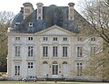
Herces Castle


Personalities
- Gabriel Gabrio (actually: Édouard Lelièvre , 1887–1946), actor
Web links
Commons : Berchères-sur-Vesgre - Collection of images, videos and audio files