
Sorel Moussel
| Sorel Moussel | ||
|---|---|---|
|
||
| region | Center-Val de Loire | |
| Department | Eure-et-Loir | |
| Arrondissement | Dreux | |
| Canton | Anet | |
| Community association | Agglo du Pays de Dreux | |
| Coordinates | 48 ° 51 ' N , 1 ° 23' E | |
| height | 64-137 m | |
| surface | 12.8 km 2 | |
| Residents | 1,804 (January 1, 2017) | |
| Population density | 141 inhabitants / km 2 | |
| Post Code | 28260 | |
| INSEE code | 28377 | |

Sorel-Moussel is a French commune with 1,804 inhabitants (as of January 1 2017) in the Eure-et-Loir in the Région Center-Val de Loire in France . It belongs to the canton of Anet and the Agglo du Pays de Dreux municipal association . Sorel-Moussel is on the border with the Normandy and Île-de-France regions .
geography
Sorel-Moussel is about 75 kilometers west of Paris . The Eure limits the municipality to the north and west. Sorel-Moussel is surrounded by the neighboring communities of Croth in the north and north-west, Saussay in the north and north-east, Anet in the east and north-east, Rouvres in the east, Abondant in the south and Marcilly-sur-Eure in the west.
Population development
| year | 1962 | 1968 | 1975 | 1982 | 1990 | 1999 | 2006 | 2013 |
|---|---|---|---|---|---|---|---|---|
| Residents | 848 | 822 | 894 | 1011 | 1317 | 1479 | 1810 | 1768 |
| Sources: Cassini and INSEE | ||||||||
Culture and sights
- Saint-Nicolas church in Sorel from the 16th century
- Saint-Roch church in Moussel from the 18th century
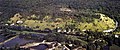
- Sorel Castle from the 16th / 17th centuries Century, since 1962 Monument historique
- Archaeological site at Le Fort-Harrouard, Monument historique since 1934
- Dolmen, monument historique since 1951
- Wash house

Saint-Roch church

Gate of the Sorel Castle
View of the archaeological site at Le Fort-Harrouard


Personalities
- Étienne Le Rallic (1891–1968), draftsman