
Maillebois
| Maillebois | ||
|---|---|---|

|
|
|
| region | Center-Val de Loire | |
| Department | Eure-et-Loir | |
| Arrondissement | Dreux | |
| Canton | Saint-Lubin-des-Joncherets | |
| Community association | Agglo du Pays de Dreux | |
| Coordinates | 48 ° 38 ' N , 1 ° 9' E | |
| height | 137-191 m | |
| surface | 41 km 2 | |
| Residents | 922 (January 1, 2017) | |
| Population density | 22 inhabitants / km 2 | |
| Post Code | 28170 | |
| INSEE code | 28226 | |
| Website | http://www.maillebois.fr/ | |

Maillebois is a French municipality with 922 inhabitants (as of January 1 2017) in the Eure-et-Loir in the region Center-Val de Loire ; it belongs to the Arrondissement Dreux and is part of the canton of Saint-Lubin-des-Joncherets (until 2015: canton of Châteauneuf-en-Thymerais ).
geography
Maillebois is about 32 kilometers northwest of Chartres . Maillebois is surrounded by the neighboring municipalities of Crucey-Villages in the north and north-west, Saint-Ange-et-Torçay in the east, Saint-Maxime-Hauterive in the south-east, Jaudrais in the south, Le Mesnil-Thomas in the south-west and Louvilliers-lès-Perche in the west and southwest.
In the northwest of the municipality is the former Deux Senonches airfield (also: Dreux-Louvilliers airfield ).
history
In 1972 the previously independent municipality of Dampierre-sur-Blévy was merged with Mallebois.
| Population development | ||||||||
|---|---|---|---|---|---|---|---|---|
| year | 1962 | 1968 | 1975 | 1982 | 1990 | 1999 | 2006 | 2017 |
| Residents | 359 | 296 | 1086 | 828 | 821 | 917 | 979 | 922 |
| Sources: Cassini and INSEE | ||||||||
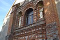
Attractions
- Saint-François-d'Assise church in Maillebois, historic monument since 1971
- Saint-Pierre church in Blévy, a historic monument since 1907
- Maillebois Castle, Monument historique since 1941/1974/2000
- Le Rouvray estate, a historic monument since 1963
- Les Moulins estate
- Forging of Dampierre-sur-Blévy, monument historique since 1993/1994
- historical buildings in Blévy
Saint-François-d'Assise church

Maillebois Castle

Rouvray manor


Personalities
- Jean-Baptiste Desmarets (1682–1762), Marquis de Maillebois and Marshal of France (1741)
- Hubert Latham (1883–1912), aviation pioneer