
Garnay
| Garnay | ||
|---|---|---|
|
||
| region | Center-Val de Loire | |
| Department | Eure-et-Loir | |
| Arrondissement | Dreux | |
| Canton | Dreux-1 | |
| Community association | Agglo du Pays de Dreux | |
| Coordinates | 48 ° 41 ′ N , 1 ° 20 ′ E | |
| height | 94-144 m | |
| surface | 14.13 km 2 | |
| Residents | 876 (January 1, 2017) | |
| Population density | 62 inhabitants / km 2 | |
| Post Code | 28500 | |
| INSEE code | 28171 | |
| Website | http://www.garnay.fr/ | |
 City Hall (Mairie) of Garnay |
||

Garnay is a French municipality with 876 inhabitants (as of January 1 2017) in the department of Eure-et-Loir , in the region of Center-Val de Loire . The municipality belongs to the Arrondissement Dreux and the canton Dreux-1 (until 2015: canton Dreux-Sud ). The inhabitants are called Garnetais .
geography
Garnay is about four kilometers southwest of Dreux am Blaise . Garnay is surrounded by the neighboring communities Vernouillet in the north and northeast, Marville-Moutiers-Brûlé in the east and southeast, Tréon in the south, Garancières-en-Drouais in the west and Allainville in the north-west.
Part of the Dreux-Vernouillet airfield is located in the municipality .
Population development
| year | 1962 | 1968 | 1975 | 1982 | 1990 | 1999 | 2006 | 2013 |
|---|---|---|---|---|---|---|---|---|
| Residents | 416 | 363 | 566 | 975 | 1,059 | 972 | 924 | 880 |
Attractions
- Saint Martin Church
- Marmousse Castle
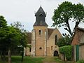
Saint Martin Church

Marmousse Castle
.jpg)

Web links
Commons : Garnay - collection of images, videos and audio files