Anet
| Anet | ||
|---|---|---|

|
|
|
| region | Center-Val de Loire | |
| Department | Eure-et-Loir | |
| Arrondissement | Dreux | |
| Canton | Anet (main town) | |
| Community association | Agglo du Pays de Dreux | |
| Coordinates | 48 ° 51 ′ N , 1 ° 26 ′ E | |
| height | 57-132 m | |
| surface | 7.85 km 2 | |
| Residents | 2,733 (January 1, 2017) | |
| Population density | 348 inhabitants / km 2 | |
| Post Code | 28260 | |
| INSEE code | 28007 | |
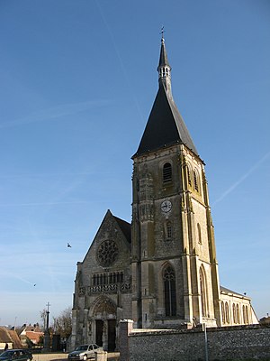
 Saint-Cyr and Sainte-Julitte Church |
||
Anet is a French commune with 2,733 inhabitants (at January 1, 2017) in the Eure-et-Loir in the region Center-Val de Loire ; it belongs to the Arrondissement Dreux and the canton Anet .
Anet is about 15 km from Dreux and Houdan . The city lies between the rivers Eure and Vesgre , which converge a little further north. The municipality is known for the Anet Castle , which Philibert Delorme had built for Diane de Poitiers at the time of King Henry II .
Population development
- 1962: 1341
- 1968: 1464
- 1975: 1700
- 1982: 2297
- 1990: 2696
- 1999: 2651
- 2012: 2673
- 2017: 2733
Attractions
Personalities
- Pascal Lainé (* 1942), writer
Web links
Commons : Anet (Eure-et-Loir) - collection of images, videos and audio files

