
Thimert-Gâtelles
| Thimert-Gâtelles | ||
|---|---|---|
|
||
| region | Center-Val de Loire | |
| Department | Eure-et-Loir | |
| Arrondissement | Dreux | |
| Canton | Saint-Lubin-des-Joncherets | |
| Community association | Agglo du Pays de Dreux | |
| Coordinates | 48 ° 34 ′ N , 1 ° 15 ′ E | |
| height | 174-254 m | |
| surface | 42.67 km 2 | |
| Residents | 1,256 (January 1, 2017) | |
| Population density | 29 inhabitants / km 2 | |
| Post Code | 28170 | |
| INSEE code | 28386 | |

Thimert-Gâtelles is a French commune with 1,256 inhabitants (as of January 1 2017) in the Eure-et-Loir in the region Center-Val de Loire ; it belongs to the Arrondissement Dreux and is part of the canton of Saint-Lubin-des-Joncherets (until 2015: canton of Châteauneuf-en-Thymerais ).
geography
Thimert-Gâtelles is about 25 kilometers northwest of Chartres . Thimert-Gâtelles is surrounded by the neighboring communities
- Châteauneuf-en-Thymerais and Saint-Sauveur-Marville in the north,
- Tremblay-les-Villages to the east and northeast,
- Mittainvilliers-Vérigny in the southeast,
- Saint-Arnoult-des-Bois and Favières in the south,
- Ardelles in the southwest,
- Saint-Maixme-Hauterive to the west and north-west.
| Population development | ||||||||
|---|---|---|---|---|---|---|---|---|
| year | 1962 | 1968 | 1975 | 1982 | 1990 | 1999 | 2006 | 2013 |
| Residents | 531 | 581 | 815 | 826 | 841 | 929 | 1,051 | 1,253 |
| Source: Cassini and INSEE | ||||||||
Attractions
- Saint-Blaise church in Gâtelles, monument historique since 1921
- Saint-Pierre church in Thimert, monument historique since 1932
- Saint-Thomas chapel from the 12th century
- Saint Laurent Chapel
- Notre-Dame chapel from the 15th century
- Remnants of a moth
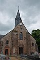
Saint-Pierre church

Saint Blaise Church


Web links
Commons : Thimert-Gâtelles - Collection of images, videos and audio files