Saint-Arnoult-des-Bois
| Saint-Arnoult-des-Bois | ||
|---|---|---|

|
|
|
| region | Center-Val de Loire | |
| Department | Eure-et-Loir | |
| Arrondissement | Chartres | |
| Canton | Illiers-Combray | |
| Community association | Entre Beauce et Perche | |
| Coordinates | 48 ° 30 ′ N , 1 ° 16 ′ E | |
| height | 163-247 m | |
| surface | 20.67 km 2 | |
| Residents | 888 (January 1, 2017) | |
| Population density | 43 inhabitants / km 2 | |
| Post Code | 28190 | |
| INSEE code | 28324 | |
| Website | http://www.saintarnoultdesbois.fr/ | |
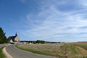
 Saint-Arnoult church |
||
Saint-Arnoult-des-Bois is a French commune with a population of 888 (as at 1st January 2017) in the department of Eure-et-Loir in the region Center-Val de Loire . Saint-Arnoult-des-Bois belongs to the Arrondissement Chartres and is part of the canton Illiers-Combray (until 2015: canton Courville-sur-Eure ). The inhabitants are called Saint-Arnolphiens .
geography
Saint-Arnoult-des-Bois is located about 17 kilometers west-northwest of Chartres . Saint-Arnoult-des-Bois is surrounded by the neighboring communities of Favières in the north and north-west, Thimert-Gâtelles in the north and north-east, Mittainvilliers-Vérigny with Mittainvilliers in the east, Fontaine-la-Guyon in the east and south-east, Courville-sur-Eure in the South and Billancelles to the west.
population
| Population development | ||||||||
|---|---|---|---|---|---|---|---|---|
| year | 1962 | 1968 | 1975 | 1982 | 1990 | 1999 | 2006 | 2017 |
| Residents | 396 | 360 | 355 | 480 | 646 | 667 | 815 | 888 |
| Sources: Cassini and INSEE | ||||||||
Attractions
- Saint-Arnoult church
- former Eure channel
