
Ver-lès-Chartres
| Ver-lès-Chartres | ||
|---|---|---|
|
||
| region | Center-Val de Loire | |
| Department | Eure-et-Loir | |
| Arrondissement | Chartres | |
| Canton | Chartres-2 | |
| Community association | Chartres metropolis | |
| Coordinates | 48 ° 24 ' N , 1 ° 30' E | |
| height | 128-161 m | |
| surface | 9.46 km 2 | |
| Residents | 783 (January 1, 2017) | |
| Population density | 83 inhabitants / km 2 | |
| Post Code | 28630 | |
| INSEE code | 28403 | |
| Website | http://www.mairie-verleschartres.com/ | |
.jpg) Town hall (Mairie) of Ver-lès-Chartres (around 1905/1908) |
||

Ver-lès-Chartres is a French municipality with 783 inhabitants (as of January 1 2017) in the department of Eure-et-Loir in the region Center-Val de Loire ; it belongs to the Arrondissement of Chartres and the canton of Chartres-2 (until 2015: canton of Chartres-Sud-Ouest ). The inhabitants are called Vernois .
geography
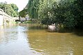
Ver-lès-Chartres is about six kilometers south of Chartres on the Eure . Ver-lès-Chartres is surrounded by the neighboring communities of Barjouville in the north, Morancez in the east and northeast, Corancez in the east and southeast, Dammarie in the south and Thivars in the west.
The A11 car route runs through the municipality . The remains of the Cistercian abbey of L'Eau are located in the municipality .
Demographics
| year | 1962 | 1968 | 1975 | 1982 | 1990 | 1999 | 2005 | 2013 |
| Residents | 350 | 330 | 560 | 708 | 748 | 724 | 763 | 819 |
| Source: Cassini and INSEE | ||||||||
Attractions
- Saint-Victor church
- lock
- Mill of Loche on the Eure
- Mill of Tachainville on the Eure
- L'Houdouenne wash house

lock
Loche Mill

L'Houdouenne wash house
.jpg)
.JPG)
.JPG)