
Clévilliers
| Clévilliers | ||
|---|---|---|
|
||
| region | Center-Val de Loire | |
| Department | Eure-et-Loir | |
| Arrondissement | Chartres | |
| Canton | Chartres-1 | |
| Community association | Chartres metropolis | |
| Coordinates | 48 ° 33 ' N , 1 ° 23' E | |
| height | 171-215 m | |
| surface | 15.78 km 2 | |
| Residents | 707 (January 1, 2017) | |
| Population density | 45 inhabitants / km 2 | |
| Post Code | 28300 | |
| INSEE code | 28102 | |
| Website | http://www.clevilliers.fr/ | |

Clévilliers is a French municipality with 707 inhabitants (as of January 1 2017) in the department of Eure-et-Loir in the region Center-Val de Loire . It belongs to the Arrondissement Chartres and the canton Chartres-1 (until 2015: canton Chartres-Nord-Est ).
geography
Clévilliers is about 14 kilometers north-north-west of Chartres city center . Clévilliers is surrounded by the neighboring communities Tremblay-les-Villages in the north and northwest, Challet in the east, Berchères-Saint-Germain in the southeast, Briconville in the south and Mittainvilliers-Vérigny in the west and southwest.
Population development
| 1962 | 1968 | 1975 | 1982 | 1990 | 1999 | 2006 | 2013 |
|---|---|---|---|---|---|---|---|
| 454 | 403 | 378 | 452 | 549 | 654 | 718 | 710 |
| Sources: Cassini and INSEE | |||||||

Mairie Clévilliers
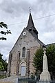
Saint-Martin church and memorial to the fallen

former train station


Web links
Commons : Clévilliers - collection of images, videos and audio files