
Pontgouin
| Pontgouin | ||
|---|---|---|

|
|
|
| region | Center-Val de Loire | |
| Department | Eure-et-Loir | |
| Arrondissement | Chartres | |
| Canton | Illiers-Combray | |
| Community association | Entre Beauce et Perche | |
| Coordinates | 48 ° 29 ′ N , 1 ° 10 ′ E | |
| height | 173-273 m | |
| surface | 25.16 km 2 | |
| Residents | 1,096 (January 1, 2017) | |
| Population density | 44 inhabitants / km 2 | |
| Post Code | 28190 | |
| INSEE code | 28302 | |

Pontgouin is a French commune with 1,096 inhabitants (as of January 1 2017) in the department of Eure-et-Loir in the region Center-Val de Loire . Pontgouin belongs to the Arrondissement Chartres and is part of the canton Illiers-Combray (until 2015: canton Courville-sur-Eure ). The inhabitants are called Gonipontins .
geography
Pontgouin is located about 24 kilometers west-northwest of Chartres on the Eure . Pontgouin is surrounded by the neighboring communities of Digny in the north, Billancelles in the east, Landelles in the south and southeast, Le Favril in the south and Saint-Maurice-Saint-Germain in the west.
The municipality's train station is on the Paris – Brest railway line .
population
| Population development | ||||||||
|---|---|---|---|---|---|---|---|---|
| year | 1962 | 1968 | 1975 | 1982 | 1990 | 1999 | 2006 | 2013 |
| Residents | 922 | 936 | 1,389 | 833 | 854 | 875 | 986 | 1,114 |
| Source: Cassini and INSEE | ||||||||
Attractions
- Saint-Lubin Church
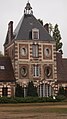
- La Rivière castle from the 17th century
- 19th century Les Vaux castle
- Plessy Manor and Manor
- Boizard lock, the starting point of the Eure Canal , a historic monument since 1910

Saint-Lubin Church

Gate to La Rivière Castle
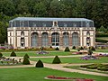
Orangery of the castle of Les Vaux
Plessy Manor


.JPG)
Personalities
- Louis-Édouard Pie (1815–1880), Bishop of Poitiers and cardinal