
Umpeau
| Umpeau | ||
|---|---|---|
|
||
| region | Center-Val de Loire | |
| Department | Eure-et-Loir | |
| Arrondissement | Chartres | |
| Canton | Auneau | |
| Community association | Chartres metropolis | |
| Coordinates | 48 ° 29 ′ N , 1 ° 40 ′ E | |
| height | 143-161 m | |
| surface | 11.49 km 2 | |
| Residents | 396 (January 1, 2017) | |
| Population density | 34 inhabitants / km 2 | |
| Post Code | 28700 | |
| INSEE code | 28397 | |

Umpeau is a French municipality with 396 inhabitants (as of January 1 2017) in the Eure-et-Loir in the region Center-Val de Loire (2015 Center). The municipality belongs to the Arrondissement of Chartres and the Chartres Métropole municipal association founded in 2012 . The residents are called Unipéliens .
geography
The municipality of Umpeau is located in the north of the Beauce countryside , 15 kilometers east of Chartres and about 60 kilometers southwest of Paris . The 11.49 km² municipal area is flat, almost treeless and characterized by a lack of surface running waters. Large grain fields prevail. The municipality of Umpeau includes the village of Umpeau (at 158 meters above sea level) and the village of Bréez (156 m) located three kilometers to the southwest . Umpeau is surrounded by the neighboring communities of Champseru in the north, Le Gué-de-Lonroi in the northeast, Oinville-sous-Auneau in the east, Béville-le-Comte in the southeast and Houville-la-Branche in the south and west.
Place name
When the community was founded in 1793, the place was already called Umpeau . A spelling until 1801 was Vinpan . From 1801, however, the name Umpeau , which is still in use today, prevailed.
Population development
| year | 1962 | 1968 | 1975 | 1982 | 1990 | 1999 | 2006 | 2016 |
|---|---|---|---|---|---|---|---|---|
| Residents | 215 | 175 | 169 | 203 | 329 | 381 | 408 | 391 |
| Sources: Cassini and INSEE | ||||||||
Attractions
- Saint-Lubin Church
- several hall crosses
- Water tower
- Saint-Lubin Church ( St. Leobinus )

tower
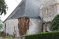
apse


Economy and Infrastructure
In the rural community of Umpeau there are 14 farms (almost exclusively grain cultivation).
The municipality of Umpeau is located on the D910 trunk road and the parallel A11 autoroute from Chartres via Ablis to Paris . The nearest train station is ten kilometers west in the municipality of Auneau-Bleury-Saint-Symphorien .
supporting documents
- ↑ toponym on cassini.ehess.fr (French)
- ↑ Umpeau on cassini.ehess.fr (French)
- ↑ Umpeau on INSEE
- ↑ Farms on annuaire-mairie.fr (French)