Le Coudray
| Le Coudray | ||
|---|---|---|
|
|
||
| region | Center-Val de Loire | |
| Department | Eure-et-Loir | |
| Arrondissement | Chartres | |
| Canton | Chartres-2 | |
| Community association | Chartres metropolis | |
| Coordinates | 48 ° 25 ′ N , 1 ° 30 ′ E | |
| height | 125-153 m | |
| surface | 5.52 km 2 | |
| Residents | 4,161 (January 1, 2017) | |
| Population density | 754 inhabitants / km 2 | |
| Post Code | 28630 | |
| INSEE code | 28110 | |
| Website | http://www.ville-lecoudray28.fr/ | |
Le Coudray is a French commune with 4,161 inhabitants (as of January 1 2017) in the department of Eure-et-Loir in the region Center-Val de Loire . It belongs to the Arrondissement of Chartres and the Canton of Chartres-2 .
geography
Le Coudray is located on the western bank of the Eure , a tributary of the Seine . Le Coudray is surrounded by the neighboring communities of Chartres in the north, Gellainville in the east and southeast, Morancez in the south, Barjouville in the southwest and Luisant in the west.
The A11 autoroute and the national route 123 run through the municipality .
Population development
| 1962 | 1968 | 1975 | 1982 | 1990 | 1999 | 2006 | 2012 |
|---|---|---|---|---|---|---|---|
| 836 | 931 | 1,251 | 1,441 | 2,022 | 2,884 | 3,652 | 4.166 |
Attractions
- Saint-Julien church, former Saint-Thibaut-des-Vignes chapel, originally from the 12th century, alterations and bell tower from the 16th century
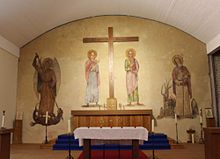
- Chapel of the former so-called barbed wire seminar (French prisoner of war camp for priests and seminarians), Monument historique
Web links
Commons : Le Coudray - collection of images, videos and audio files

