
Barjouville
| Barjouville | ||
|---|---|---|
.svg)
|
|
|
| region | Center-Val de Loire | |
| Department | Eure-et-Loir | |
| Arrondissement | Chartres | |
| Canton | Lucé | |
| Community association | Chartres metropolis | |
| Coordinates | 48 ° 25 ′ N , 1 ° 29 ′ E | |
| height | 126–157 m | |
| surface | 4.1 km 2 | |
| Residents | 1,712 (January 1, 2017) | |
| Population density | 418 inhabitants / km 2 | |
| Post Code | 28630 | |
| INSEE code | 28024 | |
| Website | http://www.barjouville.com/ | |
 Town hall (Mairie) of Barjouville |
||

Barjouville is a French commune with 1,712 inhabitants (as of January 1 2017) in the department of Eure-et-Loir in the region Center-Val de Loire ; it belongs to the Arrondissement of Chartres and the canton of Lucé (until 2015: canton of Chartres-Sud-Ouest ).
geography
Barjouville is about three kilometers south of Chartres on the Eure . Barjouville is surrounded by the neighboring communities of Luisant in the north, Le Coudray in the north-east, Morancez in the east and south-east, Ver-lès-Chartres in the south, Thivars in the south-west and Fontenay-sur-Eure in the west and south-west.
Demographics
| year | 1962 | 1968 | 1975 | 1982 | 1990 | 1999 | 2006 | 2012 |
| Residents | 240 | 354 | 697 | 975 | 1.306 | 1,393 | 1,585 | 1,660 |
| Source: Cassini and INSEE | ||||||||
Attractions
- Saint-Jacques church from the 12th century
- Barjouville Castle, a historic monument since 1994

Saint-Jacques church
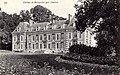
Barjouville Castle


Web links
Commons : Barjouville - collection of images, videos and audio files