Prunay-le-Gillon
| Prunay-le-Gillon | ||
|---|---|---|

|
|
|
| region | Center-Val de Loire | |
| Department | Eure-et-Loir | |
| Arrondissement | Chartres | |
| Canton | Chartres-2 | |
| Community association | Chartres metropolis | |
| Coordinates | 48 ° 22 ′ N , 1 ° 38 ′ E | |
| height | 143-156 m | |
| surface | 25.36 km 2 | |
| Residents | 1,075 (January 1, 2017) | |
| Population density | 42 inhabitants / km 2 | |
| Post Code | 28360 | |
| INSEE code | 28309 | |
Prunay-le-Gillon is a French commune with 1,075 inhabitants (as of January 1 2017) in the department of Eure-et-Loir in the region Center-Val de Loire . It belongs to the Arrondissement of Chartres and the Canton of Chartres-2 (until 2015: Canton of Chartres-Sud-Est ).
geography
Prunay-le-Gillon is about 13 kilometers southeast of Chartres city center . Prunay-le-Gillon is surrounded by the neighboring communities of Sours in the north and northwest, Francourville in the north and northeast, Moinville-la-Jeulin in the east, Boisville-la-Saint-Père in the east and southeast, Allonnes in the south, Theuville in the south and Southwest and Berchères-les-Pierres in the west.
The national route 154 runs through the municipality .
Population development
| 1962 | 1968 | 1975 | 1982 | 1990 | 1999 | 2006 | 2013 |
|---|---|---|---|---|---|---|---|
| 742 | 681 | 727 | 812 | 941 | 892 | 905 | 1,040 |
| Source: Cassini and INSEE | |||||||
Attractions
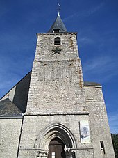
- Saint-Denis church from the 13th century, monument historique since 1920/2010
- Menhir of Ymorville
Web links
Commons : Prunay-le-Gillon - Collection of images, videos and audio files

