Mainvilliers (Eure-et-Loir)
| Mainvilliers | ||
|---|---|---|

|
|
|
| region | Center-Val de Loire | |
| Department | Eure-et-Loir | |
| Arrondissement | Chartres | |
| Canton | Chartres-3 | |
| Community association | Chartres metropolis | |
| Coordinates | 48 ° 27 ' N , 1 ° 28' E | |
| height | 133-165 m | |
| surface | 11.92 km 2 | |
| Residents | 11,182 (January 1, 2017) | |
| Population density | 938 inhabitants / km 2 | |
| Post Code | 28300 | |
| INSEE code | 28229 | |
| Website | http://www.ville-mainvilliers.fr/ | |
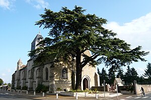
 Saint-Hilaire church |
||
Mainvilliers is a commune with 11,182 inhabitants (as of January 1 2017) in the department of Eure-et-Loir in the region Center-Val de Loire .
geography
The community is located around 90 km southwest of Paris on a large plain as a suburb of Chartres . It is surrounded by the neighboring communities of Bailleau-l'Évêque in the north-west and north, Lèves in the north-east, Chartres in the east and south-east, Lucé in the south and Amilly in the west and south-west.
Population development
| year | 1962 | 1968 | 1975 | 1982 | 1990 | 1999 | 2006 | 2016 |
| Residents | 4068 | 6119 | 8499 | 10,068 | 9956 | 10,018 | 10,331 | 11,182 |
| Sources: Cassini and INSEE | ||||||||
Attractions
- Compa , the Conservatoire d'agricole, a museum dedicated to the development, techniques and science of agriculture.
- Town Hall ( Mairie )
- Church of Saint-Hilaire, started before 949
Parish partnership
Mainvilliers has had a partnership with the local community Römerberg (Palatinate) in Germany since 1974 .
Personalities
- Philarète Chasles (1798–1873), journalist
- Henri Marchand (1898–1959), actor
Web links
Commons : Mainvilliers - collection of images, videos and audio files
