Jouy (Eure-et-Loir)
| Jouy | ||
|---|---|---|
|
|
||
| region | Center-Val de Loire | |
| Department | Eure-et-Loir | |
| Arrondissement | Chartres | |
| Canton | Chartres-1 | |
| Community association | Chartres metropolis | |
| Coordinates | 48 ° 31 ' N , 1 ° 33' E | |
| height | 106-161 m | |
| surface | 12.89 km 2 | |
| Residents | 1,939 (January 1, 2017) | |
| Population density | 150 inhabitants / km 2 | |
| Post Code | 28300 | |
| INSEE code | 28201 | |
| Website | http://www.jouy28.com/ | |
 City Hall (Mairie) of Jouy |
||
Jouy is a French commune with 1,939 inhabitants (as of January 1 2017) in the department of Eure-et-Loir in the region Center-Val de Loire . Jouy belongs to the Arrondissement Chartres and the canton Chartres-1 (until 2015: canton Chartres-Nord-Est ). The inhabitants are called Joviens .
geography
Jouy is located on the Eure , a tributary of the Seine . Jouy is surrounded by the neighboring communities of Chartainvilliers in the north, Saint-Piat in the northeast, Soultaires in the east, Coltainville in the southeast, Saint-Perst in the south, Berchères-Saint-Germain in the west and northwest and Bouglainval in the northwest.
Jouy train station is on the Paris – Brest railway line .
Population development
| 1962 | 1968 | 1975 | 1982 | 1990 | 1999 | 2006 | 2017 |
|---|---|---|---|---|---|---|---|
| 1070 | 1141 | 1286 | 1608 | 1755 | 1810 | 1888 | 1939 |
| Sources: Cassini and INSEE | |||||||
Attractions
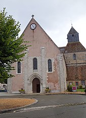
- Church of Saint-Cyr-et-Sainte-Juliette, built at the end of the 12th, beginning of the 13th century, in the 15th and 16th centuries. Century addition of the bell tower, monument historique since 1913
Web links
Commons : Jouy - collection of images, videos and audio files

