
Fresnay-l'Évêque
| Fresnay-l'Évêque | ||
|---|---|---|
|
||
| region | Center-Val de Loire | |
| Department | Eure-et-Loir | |
| Arrondissement | Chartres | |
| Canton | Voves | |
| Community association | Coeur de Beauce | |
| Coordinates | 48 ° 16 ' N , 1 ° 49' E | |
| height | 121-146 m | |
| surface | 29.04 km 2 | |
| Residents | 741 (January 1, 2017) | |
| Population density | 26 inhabitants / km 2 | |
| Post Code | 28310 | |
| INSEE code | 28164 | |
 Town hall (Mairie) of Fresnay-l'Évêque |
||

Fresnay-l'Évêque is a French municipality with 741 inhabitants (as of January 1 2017) in the department of Eure-et-Loir in the region Center-Val de Loire . The municipality belongs to the Arrondissement of Chartres and to the municipal association Cœur de Beauce, founded in 2017 .
geography
Fresnay-l'Évêque is located in the treeless landscape of Beauce about halfway between Chartres and Orléans , 35 kilometers apart. Fresnay-l'Évêque is surrounded by the neighboring communities Levesville-la-Chenard in the north and northeast, Neuvy-en-Beauce in the east, Trancainville in the southeast, Guilleville in the south, Ymonville in the west and southwest and Moutiers in the northwest. The A10 autoroute runs through the municipality to the east .
Population development
| year | 1962 | 1968 | 1975 | 1982 | 1990 | 1999 | 2006 | 2013 |
| Residents | 658 | 624 | 516 | 510 | 555 | 560 | 635 | 743 |
| Source: Cassini and INSEE | ||||||||
Attractions
- Saint-Jean-Baptiste church from the 12th century with alterations from the 16th century
- 15th century castle and chapel of Saint-Germain-le-Desiré
- Le Reclette manor , historic monument since 1928, historic bishopric
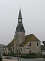
Saint-Jean-Baptiste church
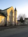
Le Reclette manor

