
Levainville
| Levainville | ||
|---|---|---|

|
|
|
| region | Center-Val de Loire | |
| Department | Eure-et-Loir | |
| Arrondissement | Chartres | |
| Canton | Auneau | |
| Community association | Portes Euréliennes d'Île-de-France | |
| Coordinates | 48 ° 29 ′ N , 1 ° 45 ′ E | |
| height | 117-156 m | |
| surface | 5.55 km 2 | |
| Residents | 389 (January 1, 2017) | |
| Population density | 70 inhabitants / km 2 | |
| Post Code | 28700 | |
| INSEE code | 28208 | |
 Town Hall (Mairie) of Levainville |
||

Levainville is a French municipality with 389 inhabitants (as of January 1 2017) in the Eure-et-Loir in the region Center-Val de Loire (2015 Center). The municipality belongs to the Arrondissement of Chartres and the Portes Euréliennes d'Île-de-France municipal association founded in 2017 .
geography
Levainville is in the north of the Beauce countryside , 18 kilometers east-northeast of Chartres and about 60 kilometers southeast of Paris . Levainville is surrounded by the neighboring communities of Auneau-Bleury-Saint-Symphorien in the north, south and east, Oinville-sous-Auneau in the south-west and Le Gué-de-Longroi in the west.
Population development
| year | 1962 | 1968 | 1975 | 1982 | 1990 | 1999 | 2006 | 2013 |
|---|---|---|---|---|---|---|---|---|
| Residents | 129 | 158 | 172 | 202 | 264 | 292 | 343 | 400 |
| Source: Cassini and INSEE | ||||||||
Attractions
- Saint-Gilles Church
- Levainville Castle
- Watermill
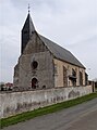
Saint-Gilles Church
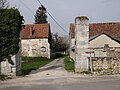
Entrance to the old castle
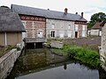
Mill


Web links
Commons : Levainville - Collection of images, videos and audio files