Champhol
| Champhol | ||
|---|---|---|

|
|
|
| region | Center-Val de Loire | |
| Department | Eure-et-Loir | |
| Arrondissement | Chartres | |
| Canton | Chartres-1 | |
| Community association | Chartres metropolis | |
| Coordinates | 48 ° 28 ′ N , 1 ° 30 ′ E | |
| height | 117-156 m | |
| surface | 5.37 km 2 | |
| Residents | 3,656 (January 1, 2017) | |
| Population density | 681 inhabitants / km 2 | |
| Post Code | 28300 | |
| INSEE code | 28070 | |
| Website | http://www.ville-champhol.fr/ | |
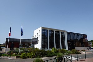
 Town Hall ( Hôtel de ville ) |
||
Champhol is a French commune with 3,656 inhabitants (as of January 1 2017) in the department of Eure-et-Loir in the region Center-Val de Loire . Champhol belongs to the Arrondissement of Chartres and the Canton of Chartres-1 .
geography
Champhol is located on the Eure , a tributary of the Seine . Champhol is surrounded by the neighboring communities of Saint-Perst in the north, Gasville-Oisème in the east, Chartres in the south and Lèves in the west.
In the south of the municipality on the border with the neighboring city of Chartres is the Base aérienne 122 Chartres-Champhol military airfield . In 1940 the airfield had already been used by the German Air Force.
history
The place was named as Campus Follis in 986 .
Population development
| 1962 | 1968 | 1975 | 1982 | 1990 | 1999 | 2006 | 2017 |
|---|---|---|---|---|---|---|---|
| 657 | 818 | 1063 | 1694 | 2235 | 2898 | 3362 | 3856 |
Attractions
- Saint-Denis church, largely destroyed by bombing during World War II
- Vauventriers Castle, under construction from 1598, completed at the beginning of the 17th century, Monument historique since 1969/2006
partnership
There is a partnership with the German municipality of Riegel am Kaiserstuhl in Baden-Württemberg .


