
Le Boullay-Thierry
| Le Boullay-Thierry | ||
|---|---|---|
|
||
| region | Center-Val de Loire | |
| Department | Eure-et-Loir | |
| Arrondissement | Dreux | |
| Canton | Dreux-2 | |
| Community association | Agglo du Pays de Dreux | |
| Coordinates | 48 ° 38 ′ N , 1 ° 26 ′ E | |
| height | 110-176 m | |
| surface | 12.87 km 2 | |
| Residents | 553 (January 1, 2017) | |
| Population density | 43 inhabitants / km 2 | |
| Post Code | 28210 | |
| INSEE code | 28055 | |

Le Boullay-Thierry is a French municipality with 553 inhabitants (as of January 1 2017) in the department of Eure-et-Loir in the region Center-Val de Loire ; it belongs to the Arrondissement Dreux and the canton Dreux-2 (until 2015: canton Nogent-le-Roi ).
geography
Le Boullay-Thierry is located about eleven kilometers south-southeast of Dreux am Eure , which also forms the northeastern municipal boundary. Le Boullay-Thierry is surrounded by the neighboring communities Le Boullay-Mivoye in the north and west, Villemeux-sur-Eure in the north and north-east, Ormoy in the east, Serazereux in the south and Tremblay-les-Villages in the west and south-west.
Route nationale 154 runs along the western edge of the municipality .
Population development
| 1962 | 1968 | 1975 | 1982 | 1990 | 1999 | 2006 | 2013 | |
|---|---|---|---|---|---|---|---|---|
| 240 | 234 | 282 | 324 | 348 | 483 | 526 | 579 | |
| Source: Cassini and INSEE | ||||||||
Attractions
- Saint-Lubin church from the 13th century, renovations from the 15th century, historic monument since 2007
- Le Boullay-Thierry Castle from the 17th / 18th centuries Century, since 2007 Monument historique
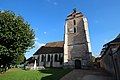
Saint-Lubin Church

Le Boullay-Thierry Castle


Personalities
- Antoine Omer Talon (1760-1811), counter-revolutionary
- Zoé Talon (1785–1852), mistress Louis XVIII.