Aich (river)
| Aich | ||
|
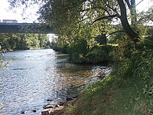
The Aich near Aichtal |
||
| Data | ||
| Water code | DE : 23818 | |
| location | Baden-Württemberg | |
| River system | Rhine | |
| Drain over | Neckar → Rhine → North Sea | |
| source | in Holzgerlingen 48 ° 38 '24 " N , 9 ° 1' 17" E |
|
| Source height | 431 m above sea level NN | |
| muzzle | near Nürtingen in the Neckar Coordinates: 48 ° 38 ′ 19 ″ N , 9 ° 20 ′ 5 ″ E 48 ° 38 ′ 19 ″ N , 9 ° 20 ′ 5 ″ E |
|
| Mouth height | 268 m above sea level NN | |
| Height difference | 163 m | |
| Bottom slope | 5.4 ‰ | |
| length | 30.4 km | |
| Catchment area | 179 km² | |
| Discharge at the Oberensingen A Eo gauge : 178 km² Location: 800 m above the mouth |
NNQ (07/28/1947) MNQ 1946/2009 MQ 1946/2009 Mq 1946/2009 MHQ 1946/2009 HHQ (05/24/1978) |
61 l / s 350 l / s 1.24 m³ / s 7 l / (s km²) 31.4 m³ / s 141 m³ / s |
| Discharge at the mouth of the A Eo : 179 km² |
MQ Mq |
1.33 m³ / s 7.4 l / (s km²) |
| Right tributaries | Sheikh | |
The Aich is an approximately 30.4 km long, left and western tributary of the Neckar in the districts of Böblingen and Esslingen in Baden-Württemberg .
geography
course
The Aich rises directly in Holzgerlingen (Boeblingen district). It flows a little north past Neuweiler , then directly south past Schönaich and through Waldenbuch .
The Aich then runs along the northern edge of the Schönbuch Nature Park , passes the Betzenberg and takes in the water of the Schaich shortly after the Neuenhaus (Esslingen district) to the east of this mountain .
Thereafter, it flows under the Aichtal bridge ( B 27 ) and then through the named after her Aichtal by the Aichtaler areas Aich and Grötzingen. After flowing through Oberensingen , the Aich flows into the Neckar near Nürtingen .
Tributaries
- Eschelbach ( right ), 2.2 km, 1.8 km²
- Aischbach ( right ), 3.1 km, 2.8 km²
- Keckbach ( right ), 1.6 km, 1.9 km²
- Krähenbach ( left ), 4.8 km, 8.1 km²
- Kohlklingenbach ( right ), 0.4 km
- Seebach ( left ), 2.1 km, 1.9 km²
- (Bach from) Losklinge ( left ), 1.6 km
- Seebach ( left ), 6.9 km, 14.8 km²
- Laubbach ( right ), 1.6 km
- Faulbach ( right ), 3.0 km
- Erbeerbühl (bach) ( left ), 1.4 km
- Groppbach ( left ), 1.7 km
- Seitenbach ( right ), 9.4 km
- Immenbach ( right ), 2.97 km
- Brunnenbach ( right ), 1.7 km
- Thief's Blade ( right ), 1.6 km
- Stellenbrunnen ( right ), 0.95 km
- Reichenbach ( left ), 8.3 miles
- Schaich ( right ), 23.6 km
- Baumbach ( left ), 7.5 km
- Baiersbach ( right ), 2.07 km
- Finsterbach ( left ), 2.3 km
- Weiherbach ( left ), 4.4 km
- Follbach ( left ), 3.5 km
- Devil's Blade ( left ), 0.7 km
fauna
The Aich is home to u. a. Rainbow trout , brown trout , brook trout , barbel , grayling , hazel , asp (isolated), carp (isolated), chub and many other species of white fish .
See also
Individual evidence
- ↑ a b c Ministry for the Environment, Climate and Energy Baden-Württemberg: Expansion potential of hydropower up to 1,000 KW in the Neckar catchment area, taking into account ecological management goals ( memento of the original from October 29, 2013 in the Internet Archive ) Info: The archive link was automatically inserted and not yet checked. Please check the original and archive link according to the instructions and then remove this notice. , 2011, p. 9, ab. on June 29, 2013 (pdf, German, 1.87 MB)
- ^ German Hydrological Yearbook Rhine Region, Part I 2009 State Institute for Environment, Measurements and Nature Conservation Baden-Württemberg, p. 113, accessed on January 22, 2016 (PDF, German, 1.85 MB).

