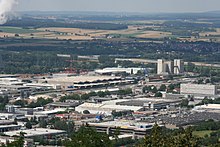
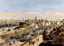
Heilbronn harbor
The port of Heilbronn is an inland port in the city of Heilbronn am Neckar . Among the ports on the Neckar, it is the most important with a share of over 50% of the handling on the river. With a throughput of 3.98 million tons of goods, it was 7th in 2010 and 8th in 2011 among German inland ports. Only ports on the Rhine had a higher turnover.
The port belongs to the city of Heilbronn and the operator is Heilbronnerversorgung GmbH (HVG) . The operating area of 78 hectares, 27 hectares of which is water, and the quay length of 7.2 kilometers are spread across the canal port on the Neckar Canal , the east port near the city limits of Neckarsulm , the salt port on the premises of the southwest German salt works and facilities on the old Neckar.
The Heilbronn industrial and port railway connects the port and the adjacent industrial areas to the rail network. The port is the starting or end point of a designated heavy-load and large-capacity transport route between Heilbronn and Ravensburg . A heavy goods quay enables the loading of heavy goods with unit weights of up to 350 tons. A container terminal completed in 2012 should enable the handling of 52,000 containers annually . The main cargo handled by the port to date has been by far salt from the salt mine of the Südwestdeutsche Salzwerke and coal (for the Heilbronn power plant ).
In Heilbronn there are 4 yacht harbors for recreational motor boating: Directly after the flood protection gate at the entrance to the Alt-Neckar is the marina of the Marine-Kameradschaft eV Also in the Alt-Neckar, more precisely in the Wilhelm Canal at the König-Wilhelm-Schleuse, is the marina of the Württemberg Motorboat Club Heilbronn eV Two more marinas can be found in the canal of the east port at Neckar kilometer 108: the first, a private marina, is located directly at the entrance to the canal. The second marina is at the end of the canal and belongs to the water sports club Osthafen Heilbronn eV
history
The Neckar already served as a shipping route in Roman times . Even in the 7th century, shipping on the Neckar was documented by water tariffs in Wimpfen and Ladenburg ; it can be assumed that Heilbronn also played a role in this. In the Hirsauer Codex , a portus (port or ship landing ) in Heilbronn is documented for the first time in 1146 . The Neckar privilege of 1333 allowed the imperial city of Heilbronn to relocate the main arm of the Neckar to its city walls and to block it with weirs for ships (not for rafts ), so that Neckar shipping for centuries in Heilbronn ended at the shipping piers on both sides of the weirs and the goods were reloaded had to become, which brought the city considerable income through its stacking rights and made the port a junction of trade routes from the Rhenish trading centers and Frankfurt am Main to Bavaria, Franconia and the Balkan countries. In the 18th century Marktschiff connection originated from Heilbronn to Frankfurt am Main, by a Palatine Faktorei was settled. The resulting disputes between Heilbronn merchants and the Electoral Palatinate factor had a negative effect on the turnover of goods. A further decline in throughput resulted from the political turmoil after the French Revolution, which led to goods traffic to the Balkans switching to the main route.
Only after the mediatization of the imperial cities and thus the transition from Heilbronn to Württemberg did the Wilhelm Canal , which was opened in 1821 and also served as a harbor, restore the continuous navigability of the Neckar. The city of Heilbronn lost its stacking right. The movement of goods on the upper Neckar developed only very slowly at first. However, the decline in sales feared for the reasons mentioned above was mitigated by the fact that the factories, which were located on the banks of the Neckar to use water power in the course of the beginning of industrialization , purchased raw materials and finished goods via the waterway, which compensated for the lower trading volume. Further circumstances conducive to the trading center were the lifting of the compulsory handling in Mannheim (1827) and Mainz (1831) as well as the abolition of prohibitive water tariffs, whereby long-distance trade with ports in Rotterdam and Amsterdam in particular flourished. In order to cope with the trading volume, the Wilhelmskanal was expanded in 1845. With the connection of Heilbronn to the rail network with the construction of the Northern Railway in 1848, the cargo handling in Heilbronn again increased sharply and additional port capacities were necessary. In 1855, near the railway facilities west of the Neckar, the Winterhafen was built, which also served as a shelter against ice and floods. Thanks to the rail link, the timber trade also took off. Large quantities of tree trunks were transported by train from the Black Forest to Heilbronn, where they were assembled into rafts and transported further downstream. Since the existing port area was insufficient for this, the desire for new areas arose in the 1850s, which was fulfilled in 1875 with the construction of the raft port . Since this was not enough, Karlshafen, named after King Karl , was built as a second raft port in 1888 . With the construction of the Heilbronn salt mine from June 1885 to February 1886, the salt port, intended exclusively for salt loading, was also built near it.
Since 1916, the Südwestdeutsche Kanalverein under the leadership of Peter Bruckmann from Heilbronn had been working out plans for a canalization of the Neckar as part of a canal connection between the Rhine and the Danube . When the Weimar Constitution came into force on August 11, 1919, the Neckar became an imperial waterway , and the Weimar National Assembly decided on April 27, 1920 to expand it from Mannheim to Plochingen . Heilbronn planned new ports adapted to the future canal. As an emergency work, the industrial port east was built in 1922/23 , today's east port near the city limits of Neckarsulm, which was extended in 1956 and expanded to include a heavy goods handling point in 1967. A planned parallel port basin to the west of it was not implemented, nor was a northern Lower Harbor in the Neckar bed near the Bleichinsel and a southern Upper Harbor between Wertwiesen and Knorrstrasse . In 1927, the canal planner Otto Konz suggested that the new Neckar Canal between Heilbronn and Böckingen itself be used as a port. The new canal port was built from 1931 to 1935 , which after its opening on July 28, 1935, gradually replaced all the earlier ports with the exception of the salt and east ports. Karlshafen had already been partially filled in in the course of the canal construction in 1931, the raft harbor was filled in between 1931 and 1934, the winter harbor was filled in in 1951. The filling of the Wilhelm Canal was averted and it has been a listed building since 1957. Until the opening of the Stuttgart port in 1958 as part of the continuation of the Neckar canalization after the Second World War , the Heilbronn port remained the Neckar port furthest upstream and accessible by modern ships.
Individual evidence
- ↑ jüp: Hafen regained seventh place . In: Heilbronn voice . May 5, 2011 ( from Stimme.de [accessed on May 15, 2011]).
- ↑ kra: Inland navigation loses 2011 . In: Heilbronn voice . April 23, 2012 ( from Stimme.de [accessed June 15, 2013]).
- ^ L 1066 Removal of level crossings in Fichtenberg . Regional Council Stuttgart, Section 47.2 (accessed April 4, 2010)
- ↑ jof: Construction of the container terminal and port railway bridge . In: Heilbronn voice . January 27, 2010 ( from Stimme.de [accessed April 4, 2010]).
- ↑ Heilbronn container terminal on the home straight . In: Heilbronn voice . April 24, 2012 ( from Stimme.de [accessed June 29, 2012]).
- ↑ The container terminal in the port is inaugurated today . In: Heilbronn voice . July 27, 2012 ( from Stimme.de [accessed on April 28, 2013]).
- ^ Kilian Krauth: Heilbronner Hafen on the upswing again . In: Heilbronn voice . March 17, 2009 ( from Stimme.de [accessed on May 15, 2011]).
- ^ Friedrich Dürr, Karl Wulle, Willy Dürr, Helmut Schmolz, Werner Föll: Chronicle of the City of Heilbronn . Volume III: 1922-1933. Heilbronn City Archives, Heilbronn 1986, p. 17 ( Publications of the Archives of the City of Heilbronn . Volume 29).
- ↑ Werner Föll: Chronicle of the city of Heilbronn . Volume X: 1970-1974. Heilbronn City Archives, Heilbronn 1999, ISBN 3-928990-68-3 , p. 152 ( Publications of the Archives of the City of Heilbronn . Volume 38).
- ^ Friedrich Dürr, Karl Wulle, Willy Dürr, Helmut Schmolz, Werner Föll: Chronicle of the City of Heilbronn . Volume III: 1922-1933. Heilbronn City Archives, Heilbronn 1986, p. 552 ( Publications of the Archives of the City of Heilbronn . Volume 29).
- ↑ According to the chronicle of the Heilbronn fishing association (accessed on January 27, 2013). It is still drawn on the official Heilbronn city map from 1925 (reprint is enclosed with Volume III of the Chronicle of the City of Heilbronn), but not on the one from 1938 (reprint is enclosed with Volume IV of the Chronicle of the City of Heilbronn).
- ↑ Alexander Renz: Chronicle of the city of Heilbronn . Volume VI: 1945-1951. Heilbronn City Archives, Heilbronn 1995, ISBN 3-928990-55-1 , p. 508 ( Publications of the archive of the city of Heilbronn . Volume 34).
- ↑ Alexander Renz: Chronicle of the city of Heilbronn . Volume VII: 1952-1957. Heilbronn City Archives, Heilbronn 1996, ISBN 3-928990-60-8 , p. 337 ( Publications of the Archives of the City of Heilbronn . Volume 35).
- ^ Julius Fekete, Simon Haag, Adelheid Hanke, Daniela Naumann: Monument topography Baden-Württemberg . Volume I.5: Heilbronn district. Theiss, Stuttgart 2007, ISBN 978-3-8062-1988-3 , pp. 112 .
literature
- Willi Zimmermann: Heilbronn - the Neckar: the city's fateful river . Verlag Heilbronner Voice, Heilbronn 1985 ( series on Heilbronn. Volume 10), ISBN 3-921923-02-6
- Roland Rösch: The Heilbronn industrial railway in Kleinäulein and in the harbor. Heilbronn City Archives, Heilbronn 2007 ( Small series of publications by the Heilbronn City Archives. Volume 53), ISBN 978-3-928990-96-7 , pp. 96–98, 108
Web links
- Website of the city of Heilbronn on the port of Heilbronn
- HNVG: Information on the Heilbronn Container Terminal
- Private website for Heilbronn harbor
- Marina: Website of the WMBC - Württembergischer Motorbootclub Heilbronn eV
- Yachthafen: Website of WSV Osthafen - Watersport Association Osthafen Heilbronn eV
Coordinates: 49 ° 9 ′ 50 ″ N , 9 ° 12 ′ 25 ″ E


