Neckar privilege
The Neckar privilege of Ludwig of Bavaria , issued on August 27, 1333 Esslingen, authorized the city of Heilbronn to the run of the river Neckar to influence and make it usable. The weirs that were then built remained an insurmountable obstacle for shipping on the river, the navigable route of which was divided here, and a constant nuisance for trade on the upper reaches into the 19th century.
history

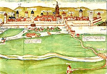
In earlier times the main arm of the Neckar near Heilbronn ran far to the west of its floodplain near Böckingen , the city of Heilbronn itself was on a smaller tributary. During a flood in 1333, there was a breakthrough, the main water channel then ran along the western city limits. This resulted in disputes between the Teutonic Order , whose meadows had been robbed by the floods, and the city's magistrate . The summoned Ludwig the Bavarian ruled on August 27, 1333 in Esslingen in a dispute between the city of Heilbronn and the Komtur and Konvent of the German House, that the former should turn and sweep the Neckar at will, the German lords for the damage to their defenses that would become free Bed and possibly, according to the estimation of four arbitrators provided by both parties, give a special replacement, leave their fishing rights and, if the reverberation from the weirs harm their mill, give another mill place on the Neckar according to the instructions of the emperor in the same vicinity and distance.
By building weirs in front of the city of Heilbronn, the river became a protective moat. The accumulated water power soon drove many urban mills . The mill of the Teutonic Order, on the other hand, which was located on the original, later silted main arm, seems to have been abandoned immediately without the city - as provided for in the emperor's arbitration - having to build a mill for the order as a replacement. The topography of the city center changed permanently due to the dammed water. This is how the Kirchbrunnenbach, which was the kennel before 1333 , came into being. In spring and autumn, the stream swelled and flooded. In the summer after the brook had receded, the market took place on the now dry floodplain. This is how the large market houses, such as the salt and bread store, and the large houses (on what later became Mosergasse) were built in these areas. Nine mills are already listed on a map from 1554 in the Stuttgart State Archives, and the continual expansion of Neckar islands and canals has resulted in more and more. The industrialization in Heilbronn later went by the Heilbronner paper mills from.
The weirs prevented ship passage on the Neckar past Heilbronn. In the Middle Ages, only rafts could pass down through a specially created raft lane , all other goods had to be handled in Heilbronn, which made the imperial city an important trading center, as the city had the right to stack the landed goods. It was not until the Wilhelm Canal was built in the first half of the 19th century that the Neckar was once again open to ships and boats.
In order to facilitate traffic across the river in the city of Heilbronn, which has been bordered by the Neckar since 1333, a bridge was built, which was made of stone in 1471. It went off in an ice corridor in 1691 and was replaced provisionally, first with two, later with only one wooden bridge. It was not until 1867 that a steel arch bridge was built a few meters north of the old bridge to connect the new station district west of the river to the city center, east of it , the successor of which today connects Kaiserstrasse and Bahnhofstrasse .
The wooden “outer bridge” crossed the old main arm of the Neckar, called “Altach”, which silted up more and more over time, which is why this useless bridge on the route to Böckingen was removed in 1770. The last relic of the Altach, the Böckinger See , was completely filled in in 1948.
Individual evidence
- ↑ Eugen Knupfer (arrangement): Document book of the city of Heilbronn . Kohlhammer, Stuttgart 1904 ( Württemberg historical sources . N. F. 5). Page 62, No. 135
- ^ Klaus Koppal: Kirchbrunnenbach-Kirchbrunnenstrasse. On the problem of a street in Heilbronn. In: Swabia and Franconia. Local history supplement of the Heilbronn voice . 17th year, no. 8 . Verlag Heilbronner Voice, Heilbronn August 14, 1967, p. 2 (dissertation).
literature
- Willi Zimmermann: Heilbronn - the Neckar: the city's fateful river . Verlag Heilbronner Voice, Heilbronn 1985 (series on Heilbronn, 10), ISBN 3-921923-02-6


