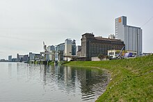
Friesenheim Island
The Friesenheimer Insel is an area in the northwest of Mannheim and is a statistical district in the Neckarstadt-West district . The island surrounded by the Rhine , Old Rhine and Neckar was created as part of the straightening of the Rhine . It is about 428 to 431 kilometers across the Rhine from BASF , which stretches along the western bank of the Rhine in Ludwigshafen .
history
The area of today's Friesenheimer Insel was originally surrounded by the Rhine in the east and belonged to Friesenheim , which is now part of Ludwigshafen - probably until the French annexation of the left bank of the Rhine around 1800 . Like the rest of the left bank of the Rhine, it was later part of the Donnersberg department and divided into a northern part that belonged to Oppau - now also a district of Ludwigshafen - and a smaller southern part that remained with Friesenheim.
The "Friesenheimer Durchstich " cut off the area on the west side of the towns during the straightening of the Rhine and made it an island. For the farmers who had their fields there, this meant that they had to set up ferries so that they could continue to cultivate their fields. After belonging to the Bavarian Palatinate in 1816, it was finally added to the state of Baden on the right bank of the Rhine in 1862.
The Friesenheimer Durchstich began on June 20, 1827 and opened on June 27, 1840. When the guide channel was opened in 1831, the underground made up of a layer of Latvians proved to be very resistant. As a result, the canal did not deepen and widen itself through the flowing water as the technicians had calculated. Instead, so much mud and sand was initially deposited that the confluence point was repeatedly clogged and costly re-excavations were necessary to complete it. The opening took place in 1862; Corrections were made until the 1880s.
as a result, the Neckar in the south received a new bed with a confluence on the straight line of the Friesenheim piercing into the Rhine. After the Altneckar was cut off at the beginning of 1869, the river took its course through the new Neckar gorge, which was finally completed in 1880.
In 1895 the city of Mannheim acquired the Friesenheimer Insel von Sandhofen , which at that time was still an independent municipality, and began building the industrial port .
Infrastructure, economy
The road connection to the Friesenheimer Insel takes place via three approaches, in the north (Altrheinbrücke), in the east ( Diffenébrücke ) and in the south (Kammerschleusenbrücke), the rail connection leads in the east over the Diffenébrücke. The industrial port, the Altrhein port and the "Friesenheimer Becken" (oil port) are located on the Friesenheimer Insel. This has less than 1000 inhabitants and is strongly characterized by industry and commerce. The Mannheim waste-to-energy plant is located there . A municipal waste disposal company operates a waste dump, the Friesenheimer Insel dump . In addition, the mostly recultivated, original garbage dump rises as a hill out of the otherwise flat terrain.
Companies such as BASF (Friesenheimer Insel plant, former Mannheim oil refinery ), Birkel , Fuchs Petrolub , GoodMills Germany (Hildebrandmühlen Mannheim) or Pfalzmühle Mannheim (PMG Premium Mühlen Group) as well as construction companies, waste recycling companies and the like. a. are represented there. The Mannheim BASF plant is connected to the main plant in Ludwigshafen by a culvert .
Landscape protection area
The western, still undeveloped part of the Friesenheimer Insel with a size of about 1.29 km² was declared a landscape protection area in 1979 . The purpose of protection is, in particular, "the last parts of the Friesenheimer Insel that are still free of structural, commercial and industrial use, in particular the narrow floodplain between the Neckar estuary and the northern Altrhein estuary, in its still relatively natural appearance and due to its ecological functions and its importance as a city-dividing open air and To get recreational space. "(See also: List of landscape protection areas in Mannheim )
additional
The former “order station” is located about 1.5 kilometers below the mouth of the Neckar at Rhine kilometer 429.5 on the Uferweg. The ships passing through were registered here, the captains were informed, depending on the shipping company's disposition, which port to call at and where which cargo was to be picked up or unloaded, or mail was handed over. The order station was in operation from around 1919 until the 1970s, when modern means of communication made it superfluous.
In the north of the Friesenheimer Insel, the oldest still functioning ferry in Germany, the Altrhein ferry Mannheim , runs across the Altrhein between the island and the Sandhofen district .
The Mannheim animal shelter has been located on Friesenheim Island near the ferry landing point since 1965.
Individual evidence
- ↑ MARCHIVUM : Chronicle star . October 7, 1862, Retrieved September 28, 2018 .
- ↑ MARCHIVUM: Chronicle star . June 20, 1827. Retrieved September 28, 2018 .
- ↑ MARCHIVUM: Chronicle star . June 27, 1840, Retrieved September 28, 2018 .
- ↑ M. Eisenlohr: The river correction near Mannheim and its effect on the development of the city. (PDF 15 MB) Reprint from the 1921 yearbook of the Hafenbautechnischen Gesellschaft (Hamburg). P. 15 and panel 7 , accessed on May 4, 2015 .
- ↑ Chronicle of the City of Mannheim - Milestones of the 19th Century
- ^ City of Mannheim: Population as of December 31, 2013 (PDF 730 KB) May 2014, accessed on June 7, 2014 .
- ↑ Ordinance of the Mannheim Mayor's Office on the "Friesenheimer Insel" nature reserve of February 15, 1979 (Journal of Laws of 1979, p. 130), PDF (195 kB)
- ^ Rhein-Neckar industrial culture : order station in Mannheim, Friesenheimer Insel. Retrieved November 11, 2017 .
Web links
Coordinates: 49 ° 32 ' N , 8 ° 27' E


