Goldbach (Pegnitz)
| Goldbach | ||
|
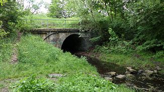
Goldbach in Gleißhammer near Juttastraße |
||
| Data | ||
| Water code | DE : 242296 | |
| location | Germany | |
| River system | Rhine | |
| Drain over | Pegnitz → Regnitz → Main → Rhine → North Sea | |
| source | east of Nuremberg in the Zerzabelshofer forest 49 ° 26 ′ 20 ″ N , 11 ° 7 ′ 57 ″ E |
|
| muzzle | in Nuremberg - Wöhrd at the height of the dam of the Wöhrder See in the Pegnitz Coordinates: 49 ° 27 '1 " N , 11 ° 5' 53" E 49 ° 27 '1 " N , 11 ° 5' 53" E
|
|
| length | approx. 3.5 km | |
| Flowing lakes | Zeltnerweiher , Tullnauweiher | |
The Goldbach is a 3.5 km long tributary to the left of the Pegnitz . It is fed by the flow of the Valznerweiher , east of Nuremberg in the Zerzabelshofer forest . The Goldbach flows through two artificially created ponds ( Zeltnerweiher and Tullnauweiher) and flows into the southern arm of the Pegnitz at the level of the Wöhrder valley crossing. Since the construction of the Wöhrder See , the mouth area from the Tullnauweiher has been piped up and is therefore no longer visible.
Water flow
The Goldbach has water all year round. At the time of the snowmelt and after heavy rain, the water level swells up many times over - more so than in any other body of water in the region. Because of the high risk of flooding and because the stream within the city is completely canalized, the city of Nuremberg wants to preserve the remaining stream floodplains outside.
history
The Goldbach was created after 1496, when the Fischbach was diverted west to today's Nuremberg old town, the remainder of the stream flowing into its former creek bed. In the past, before the watercourse was canalized, the (fish) gold brook supplied energy to drive mills and hammer mills . During the " Third Reich " the Goldbach was channeled on the Goldbachwiese, a small park in the center of Zerzabelshof . The creek was renatured here through the measures of the Federal Nature Conservation Union . The stream meadows on the edge of the Lorenzer Reichswald (upper Goldbachgrund) are looked after by the Federal Nature Conservation Association because of their great biodiversity.
Common mistake
The Goldbach has no source in the Reichswald; it only arises when the Valznerweiher runs off, which is artificially fed by the Hutgraben and the Fischbach. The southern arm of the Pegnitz on the Wöhrder Wiese is often assumed to be part of the Goldbach because the stream confluence is not visible.
Recreation
The Auen of the Goldbach are the largest natural green area in Nuremberg after the Pegnitzau. The artificial ponds in particular are an attraction for those looking for recreation. The Valznerweiher in Zerzabelshof is considered to be the most scenic pond in the region and has been one of the most important local recreation destinations in the city since the beginning of the 20th century. The city of Nuremberg planned a better development of the brook bottom, which is not publicly accessible over larger areas; the creek runs partly through private properties and allotment gardens. Only between Goldbachstrasse and Gleißhammerstrasse was a cycle and footpath built to complement the existing route from Metthingstrasse. The brook has been renatured at Aussiger Platz. The measures were part of the Goldbach green corridor project . The stream falls five meters over the weir at the outlet of the Zeltnerweiher .
