
Langwassergraben (Pegnitz)
| Langwassergraben | ||
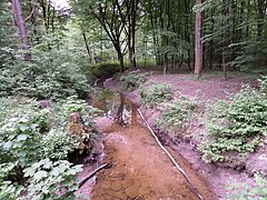
 Langwassergraben on Hutbruckweg |
||
| Data | ||
| Water code | DE : 2422932 | |
| location | Germany | |
| River system | Rhine | |
| Drain over | Pegnitz → Regnitz → Main → Rhine → North Sea | |
| source | southwest of Günthersbühl in the Behringersdorfer Forst 49 ° 30 ′ 59 ″ N , 11 ° 12 ′ 17 ″ E |
|
| Source height | 368 m | |
| muzzle | in Nuremberg - Erlenstegen at the level of Oberbürg in the Pegnitz Coordinates: 49 ° 28 ′ 14 ″ N , 11 ° 9 ′ 21 ″ E 49 ° 28 ′ 14 ″ N , 11 ° 9 ′ 21 ″ E |
|
| Mouth height | 304 m above sea level NHN | |
| Height difference | 64 m | |
| Bottom slope | approx. 8 ‰ | |
| length | approx. 8 km | |
| Left tributaries | Berry dig | |
| Right tributaries | Wolf pit | |
The Langwassergraben is an approximately 8 km long right tributary of the Pegnitz , it flows through the Behringersdorfer Forst in the Sebalder Reichswald and the district waterworks of the Nuremberg district Erlenstegen . The Langwassergraben is a 3rd order flowing water .
geography
River course
The upper course of the Langwassergraben arises in the Behringersdorfer Forst , a community-free area in the Central Franconian district of Erlangen-Höchstadt , southwest of Günthersbühl from two source streams of roughly the same length. The stream passes after the union of the source streams in a southwest direction from the right to the Wolf trench in height of the terrain elevation point tendrils flows. On Bierbrücklein flowing from left Beer ditch to and from there runs the long moat to the south, the Zapf pond over, until shortly before the Nuremberg-Cheb railway and national highway 14 behind where the running westward bends. With the exception of a short Nordschleife to cross under the A3, it pulls next to the two traffic routes that it finally crosses. The stream now runs in the area of the Erlenstegen waterworks and flows into the Pegnitz from the right across from the Oberbürg district of Laufamholz.
Tributaries
- Wolfsgraben (right)
- Bererengraben (left)
particularities
The Langwassergraben does not carry water all year round, in summer it regularly falls dry, while in winter considerable amounts of water overflow the creek bed due to the thawing snow. Since the stream runs through the drinking water extraction area of N-ERGIE and near the motorway, artificial embankments were created to prevent overflow.
At the Bierbrücklein near Behringersdorf there is a ford that was created as a sand trap. The Langwassergraben brings a lot of sand from the Reichswald, which is not wanted on the way through the drinking water area to the Pegnitz. It can be deposited here on the Bierbrücklein and taken out of the stream bed.
Picture gallery

Langwassergraben at the bagpipe
Langwassergraben at the bagpipe

Zapfweiher (Behringersdorfer Forest)


_2015-05-19_18.36.40.jpg)