
Pottenstein (Upper Franconia)
| coat of arms | Germany map | |
|---|---|---|

|
Coordinates: 49 ° 46 ' N , 11 ° 25' E |
|
| Basic data | ||
| State : | Bavaria | |
| Administrative region : | Upper Franconia | |
| County : | Bayreuth | |
| Height : | 368 m above sea level NHN | |
| Area : | 73.29 km 2 | |
| Residents: | 5171 (Dec. 31, 2019) | |
| Population density : | 71 inhabitants per km 2 | |
| Postal code : | 91278 | |
| Primaries : | 09243, 09242, 09244, 09246 | |
| License plate : | BT, EBS , ESB , KEM , MÜB , PEG | |
| Community key : | 09 4 72 179 | |
| City structure: | 35 districts | |
City administration address : |
Forchheimer Strasse 1 91278 Pottenstein |
|
| Website : | ||
| Mayor : | Stefan Frühbeißer (CWU / UWV) | |
| Location of the town of Pottenstein in the Bayreuth district | ||
  |
||

Pottenstein is a town in the district of Bayreuth ( Upper Franconia administrative district ). The state-approved climatic health resort is in Franconian Switzerland .
geography
location
Pottenstein is located in the Franconian Switzerland / Veldenstein Forest Nature Park. The Hohenmirsberger Platte (observation tower at 614 m height; one of the highest points in Franconian Switzerland) is located near the Hohenmirsberg district . The Püttlach flows through the town center , into which the Haselbrunnbach flows and, near the spa gardens, the Weihersbach flows. The community-free area Prüll is located east of the main town and is completely enclosed by the community area.
City structure
The city of Pottenstein has 35 districts :
|
The Klumpermühle is in the 20th century departed .

Neighboring communities
Neighboring communities are (starting from the north clockwise) Hummeltal , Pegnitz , Betzenstein , Obertrubach , Gößweinstein and Ahorntal .
history
Until the church is planted
The history of Pottenstein can be traced back to the first documentary mention in 918. The Castle Pottenstein was about 1060 by Count Boto Pottenstein , built (1028-1104 Aribone). In 1323 the place received city rights . The city of Pottenstein was the upper bailiff of the Bamberg monastery . In a town fire in 1736, 60 houses were destroyed and the town church was damaged.
Since the Reichsdeputationshauptschluss of 1803 the place belongs to Bavaria . In the course of the administrative reforms in the Kingdom of Bavaria , the municipality was created with the municipal edict of 1818 .
time of the nationalsocialism
From October 12, 1942 to April 16, 1945, there was a satellite camp of the Flossenbürg concentration camp in the village , in which 746 prisoners had to do forced labor for the SS Karst Defense . The prisoners were used in road construction, had to create a small reservoir as a water exercise route and opened up the nearby Teufelshöhle . In 1942/43 the SS maintained a training camp for around 600 members of the SS Karst Army. The prisoners were initially housed in a youth hostel in Mariental, and from spring 1943 in the barn of the brewery owner Mager ("Lean Barn") in Pottenstein. There are no signs of this happening in the village. The Second World War ended for Pottenstein on April 16, 1945 with the occupation by American troops , after the SS troops had withdrawn the day before.
Incorporations
Before the municipal reform , Pottenstein belonged to what was then the Pegnitz district .
On January 1, 1972, the previously independent communities Haßlach and Kirchenbirkig and parts of the area of the dissolved community Tüchersfeld were incorporated. On July 1, 1972, Püttlach was added and the Pegnitz district was dissolved at the same time. Vorderkleebach followed on January 1, 1975 and Hohenmirsberg on January 1, 1978. On May 1, 1978, the former communities of Kühlenfels, Leienfels and Regenthal and part of the dissolved community of Elbersberg were incorporated.

Population development
In the period from 1988 to 2018, the city grew from 5045 to 5226 by 181 inhabitants or 3.6%. A peak was reached on December 31, 1996 with 5549 inhabitants.
politics
City council
.jpg)
After the last local election on March 15, 2020, the city council has 20 members. The turnout was 70.2%. The choice brought the following result:
| Political party | Seats | proportion of |
|---|---|---|
| CSU | 3 | 15.97% |
| SPD | 1 | 5.13% |
| Christian Voter Union / Independent Voter Association (CWU-UWV) | 3 | 14.32% |
| The citizens of Pottenstein and the surrounding area (BPU) | 3 | 16.30% |
| Young List (JL) | 2 | 11.51% |
| Free Association of Voters (FWG) | 4th | 19.06% |
| Citizens Union (BU) | 4th | 17.70% |
Another member and chairman of the city council is the 1st mayor.
mayor
1. Mayor has been Stefan Frühbeißer (CWU-UWV) since 2002. He prevailed on March 17th that year against Dieter Bauernschmitt (CSU), who had held the office for twelve years.
From 1936 to 1945 and again from 1953 to 1972 Hans Dippold was mayor of Pottenstein. The innkeeper and farmer had already joined the NSDAP in 1931 and became NSDAP local group leader in 1939 . Dippold was an honorary citizen of the city and is named as such on a stele erected in 2015. This posthumous honor is controversial in the citizenry, but is defended by Mayor Frühbeißer.

Culture and sights
Buildings


- The 1000-year-old Pottenstein Castle was the abode of Saint Elisabeth of Thuringia in 1228
- The parish church of St. Bartholomew with rococo decor (around 1775)
- The Kunigunden Church contains an altarpiece on which Pottenstein Castle can still be seen with the keep .
- The Leienfels castle ruins in the Leienfels district
- The Jacob's ladder , a 37 m high BOS radio - and observation tower , is about 1.2 km southeast of the Castle Pottenstein in the conservation area not far from the Hofmann chapel. ⊙
Architectural monuments
Museums

- Castle museum at Pottenstein Castle
- Franconian Switzerland Museum in the Tüchersfeld district
- Execution Museum Pottenstein
Nature and leisure

- Devil's Cave , 1.5 km accessible stalactite cave . The Teufelshöhle is one of the largest and most famous caves in Germany. It was discovered in October 1922 by the geologist and mining engineer Hans Brand in the long-known Teufelsloch and opened up to visitors in two stages by Pentecost 1931. It has around 160,000 visitors annually.
- To the south-east of the town center is the Pottenstein rock pool on the Weihersbach . Opposite the Felsenbad there is a summer toboggan run and the Schöngrundsee , to which the Weihersbach is dammed, with boat rental.
- Pottenstein is located in the northern Franconian Jura climbing area . There is a climbing forest in the village .
- The Geozentrum Hohenmirsberger Platte has been offering an approx. 22 m high wooden observation tower , a fossil tapping area and a five kilometer long geological path with a geology and nature pavilion and display boards on the mountain of the same name northeast of the Hohenmirsberg district since 2008 .
- Parts of the mountain slopes around Pottenstein are designated as a nature reserve dry slopes around Pottenstein .
Geotopes
Pottenstein was awarded as a national geotope in a competition in 2006 .
- Devil's Cave near Pottenstein (show cave) (geotope number 472H008)
- Schwalbenloch B5, northeast of Pottenstein (geotope number 472H001)
- Large rabbit hole D92 (geotope number 472H002)
- Dolomite rock Hohenstein east of Kirchenbirkig (geotope number 472R050)
- Drachenfels near Mittelmühle (geotope number 472R051)
- Dolomite rock with cave Steinkirche D80 (geotope number 472R052)
- Rocks in the Leienfels forest with cave D238 (geotope number 472R131)
- Weiherstaler male near Schüttersmühle (geotope number 472R155)
- Felsburg Tüchersfeld (geotope number 472R156)
- Felsburg Schloss Pottenstein (geotope number 472R157)
Events
- Annual perpetual adoration , ending with the procession of lights on Epiphany (January 6th) with the burning of numerous mountain fires.
Economy and Infrastructure
Breweries
In Pottenstein there are two breweries that brew themselves: the Hufeisen brewery and the Mager brewery. The Wagner Brau can their beer in St. Georgen Brau in Buttenheim in wage brewing process brewing.
traffic
The municipality is crossed by the federal highway 470 , which runs in a west-east direction . Since the construction of the bypass in 1958, it has passed southwest of the town center and leads via the B2 to the A9 motorway east of the municipality (junction 44 Pegnitz).
The Franconian Marienweg runs through Pottenstein .
Personalities
sons and daughters of the town
- Martin Krauß senior (around 1490–1554), father of the classical philologist and historian Martin Crusius , the author of the Annales Suevici and professor in Tübingen
- Sebastian Förtsch (1751–1803), history and portrait painter
- Johann Baptist Reus (1868–1947), Jesuit and mystic
- Michael Horlacher (1888–1957), politician ( Bavarian People's Party , later CSU )
- Eduard von Dostler (1892–1917), officer and fighter pilot in the First World War
- Manuel Stiefler (* 1988), football player (including SV Sandhausen )
People related to the city
- Wiglaf Droste (1961–2019), author and satirist, died in Pottenstein
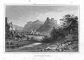
Historical illustrations

Pottenstein, steel engraving (1834) by Conrad Wießner
Pottenstein, steel engraving (1840) by Johann Poppel

Felsenbad Pottenstein, 1942

Systems of the SS Karstwehr near Pottenstein, 1942


literature
- Thomas Bernard: On the history of the rocky town Pottenstein and Franconian Switzerland. Self-published by the city of Pottenstein, Pottenstein 2019.
- Franz X. Bogner : Franconian Switzerland. An aerial portrait . Ellwanger Verlag, Bayreuth 2007, ISBN 978-3-925361-62-3 , pp. 83-88.
- Johann Kaspar Bundschuh : Pottenstein . In: Geographical Statistical-Topographical Lexicon of Franconia . tape 4 : Ni-R . Verlag der Stettinische Buchhandlung, Ulm 1801, DNB 790364301 , OCLC 833753101 , Sp. 388-389 ( digitized version ).
- Peter Engelbrecht : Tourist idyll and concentration camp horror. 2nd, unchanged edition. Rabenstein, Bayreuth 1997, ISBN 3-928683-16-0 .
- Albert Gaier: Pastor Martin Krauss, the father of the Tübingen historian and professor Martin Crusius. Fates of an Evangelical Lutheran Pastor from Upper Franconia in the 16th century. In: Leaves for Württemberg Church History. Issue 68/69 (1968/1969), pp. 497-521.
- Pleikard Joseph Stumpf : Pottenstein . In: Bavaria: a geographical-statistical-historical handbook of the kingdom; for the Bavarian people . Second part. Munich 1853, p. 622 ( digitized version ).
- Margit Freifrau von Witzingerrode: The Bartholomäuskirche - parish church in Pottenstein - past and present. In: Historischer Verein für Oberfranken (Hrsg.): Archive for the history of Upper Franconia . Volume 86. Bayreuth 2006, ISSN 0066-6335 , pp. 41-56.
Web links
- Official website of Pottenstein
- Franconian Switzerland and Pottenstein
- Pottenstein . In: Frankentourismus.de
- Pottenstein . In: Fraenkische-Schweiz.Bayern-online.de
- Pottenstein (Upper Franconia): Official statistics of the LfStat
- Entry on the coat of arms of Pottenstein (Upper Franconia) in the database of the House of Bavarian History
- Jürgen Wächter: 1000 years of the city, castle and maintenance office Pottenstein ( Memento from April 17, 2015 in the Internet Archive )
Individual evidence
- ↑ "Data 2" sheet, Statistical Report A1200C 202041 Population of the municipalities, districts and administrative districts 1st quarter 2020 (population based on the 2011 census) ( help ).
- ^ Community Pottenstein in the local database of the Bayerische Landesbibliothek Online . Bayerische Staatsbibliothek, accessed on January 5, 2020.
- ^ Website of the Flossenbürg Concentration Camp Memorial Accessed July 6, 2016
- ↑ Memorial sites for the victims of National Socialism. A documentation. Volume 1. Federal Agency for Civic Education, Bonn 1995, ISBN 3-89331-208-0 , p. 184
- ^ Official register of places for Bavaria, edited on the basis of the census of September 13, 1950, Munich, 1952
- ^ Wilhelm Volkert (ed.): Handbook of Bavarian offices, communities and courts 1799–1980 . CH Beck, Munich 1983, ISBN 3-406-09669-7 , p. 549 f .
- ^ Federal Statistical Office (ed.): Historical municipality directory for the Federal Republic of Germany. Name, border and key number changes in municipalities, counties and administrative districts from May 27, 1970 to December 31, 1982 . W. Kohlhammer, Stuttgart / Mainz 1983, ISBN 3-17-003263-1 , p. 675 to 677 .
- ↑ Template: Https: //www.pottenstein.de/wahl2020 at pottenstein.de, accessed on August 27, 2020
- ↑ A Pottenstein veteran celebrates his 70th at nordbayern.de, accessed on December 14, 2015
- ↑ Mayor runoff elections: Stefan Frühbeißer prevails against incumbent Dieter Bauernschmitt in Pottenstein ( memento of the original from December 22, 2015 in the Internet Archive ) Info: The archive link was automatically inserted and not yet checked. Please check the original and archive link according to the instructions and then remove this notice. at mainwelle.fm, accessed on December 14, 2015
- ↑ Pottenstein honors Nazi mayor in: Nordbayerischer Kurier, December 10, 2015, p. 19
- ↑ Pottensteiner Himmelsleiter observation tower on fraenkische-schweiz.bayern-online.de, accessed on January 5, 2017
- ^ Castle Museum Burg Pottenstein. In: Museen-in-Bayern.de. Retrieved September 13, 2019 .
- ↑ Official website of the Franconian Switzerland Museum Tüchersfeld
- ↑ Official website of the Scharfrichtermuseum Pottenstein
- ↑ Landscape view Hohenmirsberger Platte, Hohenmirsberg on the website of the Geopark Bavaria-Bohemia
- ↑ Geozentrum Hohenmirsberger Platte on the website of the Geopark Bavaria-Bohemia
- ↑ nordbayern.de: Lichterfest Pottenstein: Stacking wood for the spectacle , accessed on January 13, 2015
- ↑ infranken.de: Festival of Lights in Pottenstein: 1000 mountain fires burn on Epiphany, loaded on January 9, 2016, January 5, 2016

Maple Valley | Aufseß | Bad Berneck in the Fichtel Mountains | Betzenstein | Bindlach | Bischofsgrün | Creussen | Eckersdorf | Emtmannsberg | Fichtelberg | Gefrees | Gesees | Glassworks | Goldkronach | Hague | Heinersreuth | Hollfeld | Hummeltal | Church ping garden | Flour chisel | Mistelbach | Mistelgau | Pegnitz | Plankenfels | Plech | Pottenstein | Prebitz | Beak woad | Seybothenreuth | Speicherersdorf | Waischenfeld | Warmensteinach | Willow Hill
Unregulated areas of
Bischofsgrüner Forst |
Fichtelberg |
Forst Neustädtlein am Forst |
Glashüttener Forest |
Heinersreuther Forest |
Neubauer Forest North |
Prüll |
Veldenstein Forest |
Waidacher Forest |
Warmensteinacher Forest North
Altenhof | Arnleithen | Elbersberg | Geusmanns | Graisch | Haselbrunn | Hasslach | Hohenmirsberg | Kirchenbirkig | Kleinkirchenbirkig | Kleinlesau | Kühlenfels | Leienfels | Mandlau | Middle mill | Pottenstein | Prüllsbirkig | Pullendorf | Püttlach | Rackersberg | Regenthal | Rupprechtshöhe | Schüttersmühle | Siegmannsbrunn | Soranger | Stiff | Wearable | Tüchersfeld | Vorderkleebach | Waidach | Wannberg | Weidenhüll near Elbersberg | Weidenhüll near Leienfels | Weidenloh | Weidmannsgesees