Schüttersmühle
|
Schüttersmühle
City of Pottenstein
Coordinates: 49 ° 45 ′ 2 " N , 11 ° 25 ′ 40" E
|
|
|---|---|
| Postal code : | 91278 |
| Area code : | 09243 |
|
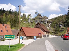
Schüttersmühle - place name sign and Weiherbacher Männchen rock formation
|
|
Schüttersmühle is a district of Pottenstein in Upper Franconia with 17 inhabitants.
location
The small village is about five kilometers east of Pottenstein on the federal highway 470 in Franconian Switzerland .
history
The mill was first mentioned in a document in 1520 as "Schüchenmuel". In 1829 Schüttersmühle had 17 residents and was part of the Elbersberg community . The Franconian Switzerland Association was founded there in 1901 . Today the Schüttersmühle inn is located in the hamlet. There is also the Zum Klumpertal kiosk as a station for hikers.
Weiherstaler male
The Weiherstaler Männchen rock formation north of Schüttersmühle became famous for its unusual shape. The rock is designated as geotope 472R155 by the Bavarian State Office for the Environment . See also the list of geotopes in the Bayreuth district .
South of Schüttermühle is the remarkable Klumpertal, a dry valley with imposing rocks and ponds.
Web links
Individual evidence
- ↑ http://www.pottenstein.de/gaesteinformation/ortsteile/ot_elbersberg ( Memento from June 15, 2015 in the Internet Archive )
- ↑ http://www.kioskzumklumpertal.ws24.cc/
- ↑ Archived copy ( Memento of the original from April 24, 2012 in the Internet Archive ) Info: The archive link was inserted automatically and has not yet been checked. Please check the original and archive link according to the instructions and then remove this notice.
- ↑ Geotope: Weiherstaler Männchen near Schüttersmühle (accessed on October 2, 2013; PDF; 175 kB)


