Püttlach (Pottenstein)
|
Püttlach
City of Pottenstein
Coordinates: 49 ° 48 ′ 14 " N , 11 ° 28 ′ 10" E
|
|
|---|---|
| Residents : | 170 |
| Incorporation : | July 1, 1972 |
| Postal code : | 91278 |
| Area code : | 09246 |
Püttlach is a district of the town of Pottenstein in the Upper Franconian district of Bayreuth in northern Bavaria .
Geography and transport links
Püttlach is northeast of the core town of Pottenstein. The federal motorway 9 runs east of the village .
The Püttlach , a left tributary of the Wiesent, flows through the village . The stream rises near Muthmannsreuth in the Lindenhardt Forest and is fed by several smaller tributaries. The Püttlach is around 28 km long and flows into the Wiesent at Tüchersfeld.
The Franconian Marienweg runs through the village .
history
On July 1, 1972, Püttlach was incorporated into Pottenstein.
Attractions
In the list of architectural monuments in Pottenstein (Upper Franconia) there are no monuments for Püttlach .
Information about the village
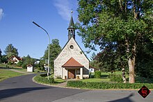
Püttlach has a small chapel, which was consecrated on August 10, 1951, a volunteer fire brigade and an inn (Gasthof Persau).
There are numerous holiday apartments for holiday guests.
The Kerwa (parish fair) always takes place on the second weekend in August.
Web links
Individual evidence
- ^ Wilhelm Volkert (ed.): Handbook of Bavarian offices, communities and courts 1799–1980 . CH Beck, Munich 1983, ISBN 3-406-09669-7 , p. 549 f .

