
Germaringen
| coat of arms | Germany map | |
|---|---|---|

|
Coordinates: 47 ° 56 ' N , 10 ° 41' E |
|
| Basic data | ||
| State : | Bavaria | |
| Administrative region : | Swabia | |
| County : | Ostallgäu | |
| Height : | 660 m above sea level NHN | |
| Area : | 22.88 km 2 | |
| Residents: | 3872 (Dec. 31, 2019) | |
| Population density : | 169 inhabitants per km 2 | |
| Postal code : | 87656 | |
| Area code : | 08341 | |
| License plate : | OAL, FÜS, MOD | |
| Community key : | 09 7 77 130 | |
| LOCODE : | DE GMI | |
| Community structure: | 5 parts of the community | |
| Address of the municipal administration: |
Westendorfer Strasse 4a 87656 Germaringen |
|
| Website : | ||
| Mayor : | Helmut Bucher (Free Wgem. Untergermaringen) | |
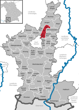
| Location of the municipality of Germaringen in the Ostallgäu district | ||
  |
||


Germaringen is a municipality in the Swabian district of Ostallgäu .
geography
The community is located on the edge of the Allgäu in the Ostallgäu district.
The following districts exist : Ketterschwang, Obergermaringen, Untergermaringen, Schwäbishofen.
The municipality has 5 officially named municipal parts (the type of settlement and the population as of March 31, 2015 are given in brackets ):
- Georgenberg ( wasteland )
- Ketterschwang (parish village, 404 E.)
- Obergermaringen ( parish village , 2590 E.)
- Riederloh (settlement, no officially named part of the municipality, 57 E.)
- Schwäbishofen ( hamlet , 19 E.)
- Untergermaringen (parish village, 786 E.)
It is 7 km to the nearby town of Kaufbeuren , 15 km to Bad Wörishofen , the closest motorway connection to the A 96 Lindau - Munich near Buchloe is 14 km and the town of Buchloe itself is 18 km away. The closest train station is in Kaufbeuren with connections to Munich , Lindau and Oberstdorf .
history
Until the church is planted
Obergermaringen emerged after the Alemannic conquest as an extension of the older "lower Germaringen". Obergermaringen is first mentioned in 1295. Germaringen belonged to the Free Imperial City of Kaufbeuren . The districts of Ober- and Untergermaringen and Riederloh belonged to Germaringen. Ketterschwang came to Bavaria in 1803 through the secularization of the imperial abbey Irsee (which owned the entire place except for the hamlet of Schwäbishof). In the course of the administrative reforms in Bavaria , the municipalities came into being with the municipal edict of 1818 . Untergermaringen is one of the oldest places in the Ostallgäu district. It was founded around 500 by the Alemannic clan of a Germar. The first mention goes back to the year 1183.
Incorporations
As part of the regional reform in Bavaria , the previously independent municipalities of Obergermaringen and Untergermaringen were merged on July 1, 1972 to form the new municipality of Germaringen. Ketterschwang was added on May 1, 1978.
Population development
From 1988 to 2008 Germaringen grew by 916 inhabitants or approx. 32%. Between 1988 and 2018 the community grew from 2900 to 3865 by 965 inhabitants or by 33.3%.
The following were counted in the municipality:
|
|
|
||||||||||||||||||||||||||||||||||||||||||||||||||||||||
before 1961 without Schwäbishofen and Riederloh; Source: Municipality of Germaringen
politics
City council and mayor
The municipal council has 16 members. In the municipal council election on March 16, 2014, the following distribution of seats resulted:
| Citizens' block Obergermaringen | 9 seats |
| Free community of voters Untergermaringen | 5 seats |
| Free voter community Ketterschwang | 2 seats |
Source: Municipality of Germaringen
Mayor is Helmut Bucher (Free Voting Association Untergermaringen).
tax income
The municipal tax revenue in 2014 amounted to the equivalent of € 1,547,000, of which the trade tax income (net) amounted to the equivalent of € 1,151,000. The debt level on December 31, 2014 was 1,023 euros. The community has been debt free since February 2014. In 2011, the per capita debt was only 35 euros / inhabitant.
coat of arms
|
|
Blazon : "floats in red a silver church with a golden roof in chorus view between the two gold-covered dome towers a sechsstrahliger gold star." |
Partnerships
Germaringen signed a partnership agreement with the French town of La Verrie (today's municipality of Chanverrie ) in the Vendée department in 1992 and 1994, respectively. However, since 1976, regular visits have been made to the parishes every four years. In 2000 the partnership monument in Germaringen was officially inaugurated. In 2001, the 25-year friendship was celebrated. During the visit in 2008, the sculpture of the partnership (title: Friendship overcomes borders) was inaugurated at the municipal office. The sculpture consists of two curved steles , which stand for the common history of the two countries Germany and France . The French column is blue and the German is golden, both colors of the country's flags. Through their reconciliation, both states created the foundation for European unification and each formulated three key terms as motto, which will always be valid. For France stands: freedom, equality, brotherhood. In Germany it is said: unity, law, freedom. These fundamental words stand as the basis of togetherness on the three-sided granite slab that carries the sculpture of the partnership.
Culture and sights
The landscape and townscape are largely shaped by the churches. Worth mentioning are St. Georg on the Georgiberg in Untergermaringen and St. Wendelin in Obergermaringen.
St. George
Believers used to make a pilgrimage to St. George's Church on the Georgifest (April 23) from the near and far. The footpath up the mountain is lined with old linden trees and five baroque brick way stations from around 1700.
The east- facing tuff block construction dates from the Romanesque period around 1180. The brick roof tower was only built in the 15th century. The building was extensively renovated from 1966 to 1970 and largely restored to the original Romanesque architectural style; Baroque additions also demolished. Inside, a Romanesque apse fresco and fragments of later paintings (New Testament scenes, the legend of St. George and larger-than-life St. Christopher) were uncovered. In the apse, Christ is depicted as Pantocrator in a mandorla , surrounded by the symbols of the four evangelists, enthroned above the heavenly Jerusalem. Christ is accompanied on both sides by an angel and a saint. Below the mandorla, according to Mt. 25, 1–13, the 5 wise and 5 foolish virgins are shown as half-figures. Twelve men are depicted below the virgins, so an interpretation as the twelve apostles is obvious. What is unusual, however, is the lack of the usual attributes of the apostles such as B. Key or St. Andrew's Cross. Each of the depicted holds a book in their hands. In an otherwise good condition, the lower areas are unfortunately not preserved. The importance of the apse painting of St. George is based on its quality with the abundant use of the precious lapis lazuli blue and its uniqueness in Bavarian Swabia.

On the south side of the nave, a copy of the Romanesque crucifix, the original (now in the Bavarian National Museum ) was originally placed in the middle of the choir arch.
The baroque coffered ceiling in the nave (dated 1690) and statues and paintings have been preserved from a renovation at the end of the 17th century.
St. Wendelin
St. Wendelin in Obergermaringen was mentioned in writing as early as the 16th century as a pilgrimage church to St. Wendelin. In place of the original chapel , the construction of a baroque church began in 1697. The blueprint probably comes from the Wessobrunn builder and plasterer Johann Schmuzer . In 1727 the building with two domed towers was completed.
Inside the church there is an abundance of wall and ceiling paintings as well as rich stucco by Wessobrunn masters. There are numerous frescoes on the walls depicting the life and legend of St. Wendelin. The vaulted fields are decorated with paintings with representations from the Old and New Testament, framed by lush stucco ornaments.
A relic of St. Wendelin is kept in the church, set in a magnificent relic monstrance. Pilgrims still come today for pilgrimages. The traditional Wendelinsritt was brought back to life and takes place every three years. The first large demonstrable tour with horses and carts took place on June 12, 1924 on the 1300th anniversary of the death of the cattle patron. Every year at the Wendelinsfest in October (Tuesday after the church fair) there are also blessings of cattle. Saint Wendelin is still very much venerated by the Obergermaring parish. There are also pilgrimages and shepherds' festivals. Every Easter Monday there is a festive service with worship of relics in honor of Saint Wendelin.
Extensive renovation work took place in 2016-2017. The roof structure and beams were given new timbers, the two towers had to be clamped together and the west gable had to be stabilized. The edition of the gallery was also increased. In addition, the entire shell was cleaned in the interior, the stucco work restored and the altarpieces and votive panels refreshed. In the outer area, repair work was carried out on the base.
On July 22nd, 2017, after more than a year of renovation, Auxiliary Bishop Florian Wörner celebrated a festive service together with the local clergy and the parish.
St. Jacob the Elder
The church of St. James maj. in the district of Ketterschwang is a rococo hall building with a gable roof, has a north tower with an onion dome (built in 1716) as well as centralizing chapel extensions and wall structures. In 1757/58 the church was rebuilt under the direction of Pastor Johann Joseph Greill, the plan may have been by Nikolaus Schütz (formerly Palier with Dominikus Zimmermann ). The frescoes were created in 1758 by Johann Baptist Enderle , including scenes from the life of the church patron St. Jakobus. The ceiling fresco in the nave shows the apparition of James at the Battle of Clavijo in 844, in which, according to legend, he helped King Ramiro I of Asturias to victory against the Moors.
From 2016 to 2018 the church was renovated at a cost of 1.1 million euros. Among other things, the structural security of the church (roof structure, ceiling of the main room) was restored and the frescoes cleaned and repaired. Parts of the picture that were partially painted over in earlier epochs were uncovered and restored in the original style.
Architectural monuments
Economy and Infrastructure
economy
In 1998 there were 25 employees in the field of agriculture and forestry, 387 in the manufacturing sector and 128 in the field of trade and transport. In other areas of the economy 115 people were employed at the place of work subject to social security contributions. There were a total of 1,139 employees at the place of residence subject to social security contributions. There were none in the manufacturing industry (as well as mining and quarrying of stone and earth), and there were six in the construction industry. In addition, in 1999 there were 69 farms with an agriculturally used area of 1,993 ha. Of this, 625 ha were arable land and 1,367 ha were permanent green space.
Significant resident companies:
- Otto Nocker GmbH, meat and sausage products
- GRUMA Nutzfahrzeuge GmbH, agricultural machinery technology
- International forwarding company Karl-Heinz Dietrich GmbH & Co. KG, freight and transport
traffic
The district of Obergermaringen is directly connected to the federal highway 12 .
education
The following institutions exist (as of 2012):
- two kindergartens: St. Michael in Obergermaringen with one full-day and three half-day groups, as well as a day nursery and St. Georg in Untergermaringen with one full-day group
- a primary and secondary school with an M-branch (possibility of secondary school leaving certificate)
societies
In addition to the sports club SVO Germaringen e. V. approx. 40 other clubs and groups.
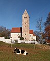
Georgiberg near Untergermaringen

Ketterschwang

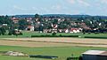
Obergermaringen from the northwest
Untergermaringen

Germaringen with the Allgäu Alps


Personalities
- The writer Peter Dörfler (1878–1955) was born on a farm in Untergermaringen.
- The musician Ernst Mosch , head of the Egerland musicians, lived in Untergermaringen . Mosch ran a music publisher with an extravagant publishing house on the main street in Obergermaringen. The music publisher he founded still exists today.
- Rupert Egenberger , who was born in Obergermaringen, was a well-known special education teacher.
- The 2010 Paralympics winner in Vancouver in the 12.5 km biathlon Willi Brem attended the Ketterschwang primary school.
- The carom player Wolfgang Zenkner , who was born in Germaringen, won the world title in the cover in 2009 .
literature
- Municipality of Germaringen (ed.): Chronicle of a municipality: history and development of Obergermaringen, Untergermaringen, Ketterschwang, Schwäbishofen and Riederloh. pro-Literatur-Verlag, Mammendorf 2004.
Web links
- Local government
- Germaringen: Official statistics of the LfStat (PDF; 1.1 MB)
Individual evidence
- ↑ "Data 2" sheet, Statistical Report A1200C 202041 Population of the municipalities, districts and administrative districts 1st quarter 2020 (population based on the 2011 census) ( help ).
- ^ Municipality of Germaringen in the local database of the Bavarian State Library Online . Bayerische Staatsbibliothek, accessed on August 17, 2019.
- ^ Wilhelm Volkert (ed.): Handbook of Bavarian offices, communities and courts 1799–1980 . CH Beck, Munich 1983, ISBN 3-406-09669-7 , p. 492 .
- ↑ a b c Federal Statistical Office (ed.): Historical municipality directory for the Federal Republic of Germany. Name, border and key number changes in municipalities, counties and administrative districts from May 27, 1970 to December 31, 1982 . W. Kohlhammer, Stuttgart / Mainz 1983, ISBN 3-17-003263-1 , p. 779 .
- ↑ Administration> Employees and their areas of expertise. Municipality of Germaringen, accessed on July 18, 2020 .
- ^ Entry on the coat of arms of Germaringen in the database of the House of Bavarian History
- ^ La Verrie partnership. Municipality of Germaringen, accessed on October 16, 2015 : “ ... and it was agreed to form an official partnership at the next meetings on August 4, 1992 in Germaringen and on August 2, 1994 in La Verrie. "
- ^ Crucifixus, unknown artist. Retrieved October 3, 2019 .
- ↑ Timetable for St. Jakobus on schwabenmedia.de , accessed on August 12, 2018

Aitrang | Baisweil | Bidingen | Biessenhofen | Buchloe | Eggenthal | Eisenberg | Friesenried | Feet | Germaringen | Görisried | Günzach | Halbch | Hopferau | Irsee | Jengen | Kaltental | Kraftisried | Lamerdingen | Lechbruck am See | Lengenwang | Marktoberdorf | Mauerstetten | Nesselwang | Obergünzburg | Oberostendorf | Osterzell | Pforzen | Pfronten | Rettenbach am Auerberg | Vineyards | Vineyards on the Forggensee | Ronsberg | Roßhaupten | Backwood | Ruderatshofen | Schwangau | Seeg | Stötten am Auerberg | Stöttwang | Unterthingau | Untrasried | Waal | Forest | Westendorf