
Administrative community Westendorf
| coat of arms | Germany map | |
|---|---|---|
 Help on coat of arms |
Coordinates: 47 ° 56 ' N , 10 ° 43' E |
|
| Basic data | ||
| Existing period: | 1978– | |
| State : | Bavaria | |
| Administrative region : | Swabia | |
| County : | Ostallgäu | |
| Area : | 85.7 km 2 | |
| Residents: | 7586 (Dec. 31, 2019) | |
| Population density : | 89 inhabitants per km 2 | |
| License plate : | OAL, FÜS, MOD | |
| Association key : | 09 7 77 5751 | |
| Association structure: | 5 municipalities | |
| Association administration address : |
Kaltentaler Str. 1 87679 Westendorf |
|
| Website : | ||
| Location of the administrative community Westendorf in the Ostallgäu district | ||
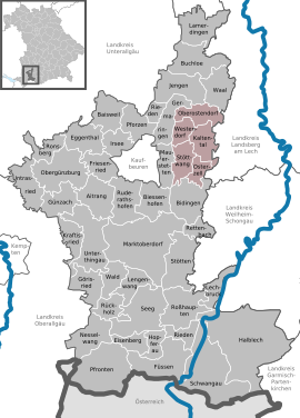  |
||

The administrative community Westendorf in the Swabian district of Ostallgäu has existed since the municipal reform on May 1, 1978. Its member communities are:
- Kaltental , market , 1694 inhabitants, 22.14 km²
- Oberostendorf , 1479 inhabitants, 21.04 km²
- Osterzell , 714 inhabitants, 10.8 km²
- Stöttwang , population 1873, 19.79 km²
- Westendorf , 1826 inhabitants, 11.93 km²
The administrative association is based in Westendorf.
Individual evidence
- ↑ "Data 2" sheet, Statistical Report A1200C 202041 Population of the municipalities, districts and administrative districts 1st quarter 2020 (population based on the 2011 census) ( help ).
Administrative communities in the Ostallgäu district
Biessenhofen | Buchloe | Eggenthal | Obergünzburg | Pforzen | Roßhaupten | Seeg | Stötten am Auerberg | Unterthingau | Westendorf
Disbanded: Germaringen | Lechbruck