
Brentenjoch
| Brentenjoch | ||
|---|---|---|
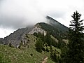
 Brentenjoch from the Lumberger ridge |
||
| height | 2000 m above sea level A. | |
| location | Tyrol , Austria | |
| Mountains | Tannheimer Berge , Allgäu Alps | |
| Dominance | 3.7 km → Great Schlicke | |
| Notch height | 282 m ↓ Vilser Jöchl | |
| Coordinates | 47 ° 31 '56 " N , 10 ° 34' 56" E | |
|
||

The Brentenjoch is a 2000 meter high mountain in the Tannheimer Group . The summit and main structure are located in the Austrian state of Tyrol . A north-east ridge connects the main summit with the secondary summit Roßberg , which is 1945 meters high.
Origin of name
Originally the name "Roßberg" was used on the Pfrontener and Gräner side for the whole mountain and is documented for the first time in 1561 in a Tannheimer document. “Roßberg Saul” was used on the Vilser side. However, the name “Brentjoch” was used for a leveling zone in the southern flank. This name gradually became the official name for the main summit. The name could come from slash and burn in the pine forest.
Location and surroundings
The Brentenjoch rises above the Vilstal near Pfronten , from which it is six and a half kilometers away. The distance to Vils and Grän is four kilometers. To the west of the Brentenjoch lies the Aggenstein (1985 m), the border between Germany and Austria runs over the notch between the two mountains. The Alptal runs east of the mountain, and the Seebach valley stretches to the southwest .
bases
On the Aggenstein, a little above the notch between the mountains, is the Bad Kissinger Hütte (1792 m). The hut, which was first built in 1880, was previously called the Pfrontener hut. It is open in summer from May to October and offers guests dormitories and beds. A winter room is available in winter .
In the Alptal is the Vilser Alm (1228 m), which is open all year round with a few interruptions. It offers space for 44 people.
Ascents
Several climbs lead to the Brentenjoch. Starting points are the Gräner districts Enge and Lumberg as well as the city of Vils.
From Enge the path first leads over a forest path into the Seebach valley. Along the valley on normal hiking trails you will reach the Sebenalm; from there the path climbs to the Vilser Jöchl (1718 m). You reach the free south flank through a forest of mountain pines and from there you go over the flat south ridge to the summit. A road from Vils also leads up to the Vilser Alm and continues to the Durchachalm. From there, a hiking trail also leads up to the Vilser Jöchl.
The Tannheimer Höhenweg connects the Bad Kissinger Hütte with the Brentenjoch via its west ridge. The mountain station of the cable car to the Füssener Jöchl is the starting point for the Gräner Höhenweg, which leads over the Sefensattel into the Sebental valley and to the Sebenalm. A hiking trail leads from the mountain station of the Breitenbergbahn to the notch between Brentenjoch and Aggenstein.
To reach the Roßberg over the partially exposed ridge, absolute surefootedness and elementary climbing skills are necessary. Climbing is possible on the north face.
photos

Summit cross

North flank
West ridge

Roßberg and Forggensee

Brentenjoch from the north


literature
- Kompass hiking, bike and ski tour map: Sheet 04 Tannheimer Tal (1: 35,000). ISBN 978-3-85491-644-4 (February 2007)
Web links
- Pfronten - Brentenjoch - Vilser Alm - Tour description on allgaeu-ausfluege.de
Individual evidence
- ^ Thaddäus Steiner : Allgäu mountain names . 2nd Edition. Kunstverlag Josef Fink, Lindenberg 2008, ISBN 978-3-8987-0389-5 (p. 36 & 164).