
Breitenberg (Tannheim Mountains)
| Breitenberg | ||
|---|---|---|
 Aggenstein and Breitenberg |
||
| height | 1838 m | |
| location | Bavaria , Germany | |
| Mountains | Tannheimer Berge , Allgäu Alps | |
| Dominance | 1.2 km → Aggenstein | |
| Notch height | 198 m ↓ notch to Aggenstein | |
| Coordinates | 47 ° 32 '56 " N , 10 ° 32' 51" E | |
|
||
| Type | Plateau summit | |
| rock | Limestone from the main dolomite | |

The Breitenberg is a 1,838 meter high mountain near Pfronten in the Ostallgäu district of the German state of Bavaria .
Location and surroundings
The Breitenberg belongs to the Bavarian part of the Tannheimer Mountains . Geologically, it consists for the most part of the limestone of the main dolomite . The notch height of the Breitenberg is at least 198 meters, its dominance 1.2 kilometers, with the Aggenstein being the reference mountain in each case. Due to its easy accessibility, it is a popular destination that can also be reached by cable car from Pfronten. The managed mountain inn Ostlerhütte is located in the area of the summit . The mountain station of the cable car is the starting point for climbing the 1,985 meter high Aggenstein. In winter it offers opportunities for skiing, with a chair lift and four drag lifts in addition to the gondola lift.
Mountain railways
The Breitenbergbahn takes you up to the Breitenberg . The 2005 meter long 4- person gondola lift overcomes a height difference of 656 meters and was built in 1993. The valley station is at an altitude of 845 meters; the mountain station is at around 1501 m.
The valley station of the Hochalpbahn is located near the mountain station of the Breitenbergbahn . It is a 4- seater chairlift built by Leitner AG in 2004 , the mountain station of which is at an altitude of 1677 m. The length of the chairlift is 784 meters. Below the valley station of the Hochalpbahn is the managed Hochalphütte at 1510 meters.
Paragliding on the Breitenberg
There are four starting places for paragliders on the Breitenberg: The fire place about 10 minutes walk above the middle station, past the Hochalp hut, the north start place about 3 minutes further uphill along the hiking path, the Kesselmoos about 5 minutes walk downhill from the summit station of the Hochalpbahn as well as the Engerle , from the summit station of the Hochalpbahn, about 15 minutes' walk uphill towards Ostlerhütte.
The landing site is 500 m southwest of the valley station.
The largest local paragliding association is the Ostallgäuer Gleitschirmflieger eV , whose website has a question-and-answer page for both guest and non-flyers.
Transmitters
|
Sender Pfronten
|
|
|---|---|
| Basic data | |
| Place: | Mountain station of the Breitenbergbahn |
| Country: | Bavaria |
| Country: | Germany |
| Coordinates : | 47 ° 32 ′ 55 " N , 10 ° 34 ′ 13" E |
| Use: | Broadcasting station |
| Accessibility: | Transmission system not accessible to the public |
| Owner : | Bavarian radio |
| Data on the transmission system | |
| Waveband : | VHF volume II and III |
| Radio : | FM , DAB |
At the mountain station of the Breitenbergbahn there is the Pfronten transmitter, a filler transmitter for analog and digital broadcasting ( Bayerischer Rundfunk , Antenne Bayern , Deutschlandfunk and DAB ) that supplies the Pfronten, Füssen and Schwangau areas .
Analog radio (FM)
In the case of directed radiation, the main radiation directions are given in degrees in the antenna diagram.
|
Frequency (MHz) |
program | RDS PS | RDS PI | Regionalization |
ERP (kW) |
Antenna pattern round (ND) / directional (D) |
Polarization horizontal (H) / vertical (V) |
|---|---|---|---|---|---|---|---|
| 92.3 | Bavaria 1 |
B1_Schw_ Bavaria_1 |
D911 (regional) D311 |
Swabia | 0.05 | D. | H |
| 89.1 | Bavaria 2 |
Bayern2S Bayern_2 |
D412 (regional) D312 |
Southern Bavaria | 0.05 | D. | H |
| 93.5 | Bayern 3 | BAYERN 3 | D313 | - | 0.05 | D. | H |
| 102.4 | BR classic | BR CLASS | D314 | - | 0.05 | D. | H |
| 107.8 | B5 currently | B5_akt__ | D315 | - | 0.05 | D. | H |
| 104.7 | Antenna Bavaria | ANTENNA_ | D318 | - | 0.05 | D. | H |
| 96.5 | Deutschlandfunk | __DLF___ | D210 | - | 0.02 | D. | H |
Digital radio ( DAB )
DAB is broadcast in vertical polarization and in single-frequency mode with other transmitters.
gallery
Breitenberg with Pfronten from the north

Breitenberg in spring

Breitenberg from the south

Breitenberg from the north
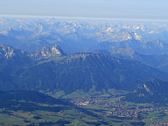
View from the Breitenberg to the northeast

Breitenberg from the east

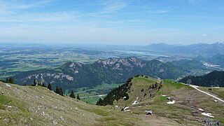
Hochalphütte and mountain station

Breitenberg, view from the Aggenstein


Literature and map
- Dieter Seibert, Alpine Club Leader Allgäu Alps. Munich 2004, ISBN 3-7633-1126-2 .
- Freytag and Berndt, hiking map 1: 50,000, sheet WK 352, Ehrwald, Lermoos, Reutte, Tannheimer Tal
Web links
Individual evidence
- ↑ Ostler Hut. The hut with a heart at 1838 m. In: huette-mit-herz.de. Retrieved June 7, 2019 .
- ↑ 4-MGD Breitenbergbahn. Lift database. In: lift-world.info. October 9, 2013, accessed June 7, 2019 .
- ↑ 4-CLF Hochalpbahn. Lift database. In: lift-world.info. October 9, 2013, accessed June 7, 2019 .
- ↑ Hochalphütte (1510 m). In: allgaeu.de. Retrieved June 7, 2019 .
- ↑ Hochalphütte. In: Breitenbergbahn.de. Retrieved June 7, 2019 .
- ↑ Ostallgäuer Gleitschirmflieger eV, FAQ for guest pilots: https://www.oal-gs.de/gelaende/faq-fuer-gastpiloten/
- ↑ Ostallgäuer Gleitschirmflieger eV, FAQ for non-flyers: https://www.oal-gs.de/links/faq-fuer-nichtflieger/
- ↑ Bayern 2 cannot be reached on VHF. Transmitter shutdown Pfronten. In: br.de . Bayerischer Rundfunk , September 8, 2015, accessed on June 7, 2019 : "The transmitter supplies the areas of Pfronten, Füssen and Schwangau."
Remarks
- ↑ Exact value not known, stated value is a minimum value (can be up to 19 meters higher). It was determined from the distance between the contour lines (20 meters in altitude ) on a topographic map ( scale 1: 25,000).