Tannheim (Tyrol)
|
Tannheim
|
||
|---|---|---|
| coat of arms | Austria map | |
|
|
||
| Basic data | ||
| Country: | Austria | |
| State : | Tyrol | |
| Political District : | Reutte | |
| License plate : | RE | |
| Surface: | 51.28 km² | |
| Coordinates : | 47 ° 30 ' N , 10 ° 31' E | |
| Height : | 1097 m above sea level A. | |
| Residents : | 1,105 (January 1, 2020) | |
| Postal code : | 6675 | |
| Area code : | 05675 | |
| Community code : | 7 08 32 | |
| NUTS region | AT331 | |
| Address of the municipal administration: |
Höf 36 6675 Tannheim |
|
| Website: | ||
| politics | ||
| Mayor : | Markus Eberle (Active Tannheim) | |
|
Municipal Council : (2016) (13 members) |
||
| Location of Tannheim in the Reutte district | ||
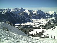
 View of Tannheim |
||
| Source: Municipal data from Statistics Austria | ||
Tannheim is a municipality with 1105 inhabitants (as of January 1, 2020) in the Reutte district in Tyrol ( Austria ).
geography
Tannheim is the main town in the Tannheimer Valley , through which the Vils flows. It forms a clustered village that is surrounded by individual hamlets that have grown into larger settlements through recent settlement expansions.
You can get to Tannheim or the Tannheimer Tal either from Weißenbach over the Gaichtpass, from Hindelang over the Oberjochpass or from Pfronten through the Engetal.
As a mountain of Tannheim of standing just north applies Einstein .
Community structure
|
structure
|
||||||
|
Legend for the breakdown table
|
The municipality consists of a single cadastral municipality or locality of the same name , after the remaining localities were deleted in October 2013 by an ordinance of the Tyrolean state government. Since December 1, 2012, the municipality has new street names.
Neighboring communities
Four of the six neighboring communities are in the Reutte district, two in Germany.
| Zöblen | Pfronten (Bavaria) | |
| Bad Hindelang (Bavaria) |

|
Grän |
| Weißenbach am Lech | Nesselwängle |
history
The Tannheimer valley was settled from the west, i.e. from the Allgäu , only the extreme east with Nesselwängle, Gaicht and Rauth was settled from Aschau am Lech.
Originally the Tannheimer Tal belonged to the extensive property with which the Franconian rulers equipped the diocese of Augsburg between 750 and 850 on the occasion of its re-establishment or re-establishment. In 1059, King Heinrich IV gave the Augsburg bishop, among other things, the ban on wildlife in the forest between Lech, Wertach and Iller and the right to colonize, i.e. the right to clearing and laying out settlements. The bishop passed property and rights on to members of the nobility as fiefdoms; around 1300, three quarters of the Tannheimer Tal, still used as an alp, was owned by the Counts of Montfort and a quarter by the Lords of Rettenberg.
Ecclesiastically, the Tannheimer Tal belonged to the Sonthofen parish, with the exception of Jungholz (Wertach parish) .
On September 17th, the inhabitants of the valley celebrate the valley holiday every year. On this day there is a festive service followed by a procession in memory of the well-fortified ancestors who fled the French on September 17, 1796 and thus prevented an impending foreign rule.
Manuel Neuer married in Tannheim in May 2017 .
Population development

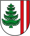
coat of arms
Blazon : "In silver a green fir tree, two red sticks on the left edge of the shield."
The colors of the municipality flag are green and white.
The coat of arms awarded by the Tyrolean provincial government on May 8, 1984 is symbolized by part of the municipality's name. The fallen shield symbolizes the dukes in Austria as Tyrolean sovereigns who acquired the entire Tannheimer Valley at the turn of the modern age. For this purpose, the valley with the main town Tannheim was raised to the bar and was part of the Ehrenberg court .
Culture and sights
- The parish church of St. Nicholas was first mentioned in a document in 1377. After the dilapidated Gothic church was demolished, today's mighty baroque church was built in 1722. The floor plan is based on Innsbruck Cathedral and is the second largest country church in the Diocese of Innsbruck after Neustift in the Stubaital .
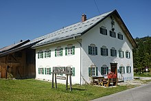
- Local history museum Tannheimer Tal in the Felixe Minas house
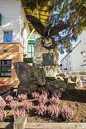
- Andreas Hofer Monument (erected in 1909)
- Chapels
| Surname | District | built |
|---|---|---|
| Mariahilf plague chapel | Oberhöfe | 1649 |
| St. Martin Chapel | Innergschwend | 1494 |
| St. Sebastian Chapel | mountain | 1653 |
| Sacred Heart Chapel | mountain | 1796 |
| St. Leonhard plague chapel | Kienzen | 1488 |
| St. Michael Chapel | Kienzen | 1680 |
| Trinity Chapel | Kienzerle | 1680 |
| Lourdes Chapel in the grotto | Tannheim | 1902 |
Economy and Infrastructure
tourism
Tannheim has numerous tourist offers such as:
- the Vilsalpsee with its nature reserve
- Hiking and themed trails, via ferratas and climbing routes, summit hikes
- Road bike, e-bike and mountain bike tours,
- Neunerköpfle ski area
- Classic cross-country skiing and skating
- Toboggan run, winter hiking trails, snowshoeing
The hotels with the tourist infrastructure and the mountain railway on the Neunerköpfle make Tannheim an important two-season tourist community in the valley.
education
- kindergarten
- Elementary school
- New middle school Tannheimer Tal
Web links
- 70832 - Tannheim. Community data, Statistics Austria .
Individual evidence
- ↑ Martin Bitschnau , Hannes Obermair : Tiroler Urkundenbuch, II. Department: The documents on the history of the Inn, Eisack and Pustertal valleys. Volume 1: By the year 1140 . Universitätsverlag Wagner, Innsbruck 2009, ISBN 978-3-7030-0469-8 , p. 206, no. 228 .
- ↑ Frankfurter Allgemeine Zeitung , May 24, 2017, p. 7.
- ↑ Coat of arms of the community of Tannheim


