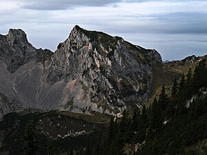
Schartschrofen
| Schartschrofen | ||
|---|---|---|
|
Schartschrofen from the northeast |
||
| height | 1968 m above sea level A. | |
| location | Tyrol , Austria | |
| Mountains | Tannheimer Berge , Allgäu Alps | |
| Dominance | 0.4 km → Rote Flüh | |
| Notch height | 92 m ↓ yellow notch | |
| Coordinates | 47 ° 30 '11 " N , 10 ° 36' 8" E | |
|
|
||
| Normal way | over the Füssener Jöchl | |
The Schartschrofen is a 1968 m high rocky summit in the Tannheimer Mountains , a subgroup of the Allgäu Alps . It is located northwest of the Roten Flüh and south of the Füssener Jöchl.
Ascent
Two marked paths lead to the Schartschrofen. The normal route leads from the Tannheimer Tal over the Füssener Jöchl - up to this point it is also possible to take the cable car from Grän - on to the Hallgernjoch and from there to the summit. Over the 150 m high south-east ridge, the Friedberger via ferrata , which is secured with wire rope, first leads over the ridge and, after crossing the southern flank, finally through a channel to the summit.
literature
- Dieter Seibert: Allgäuer Alpen Alpin, alpine club guide . Munich, Bergverlag Rudolf Rother 2004. ISBN 3-7633-1126-2
- Eugen E. Hüsler: Via ferrata atlas Alps . Munich, Bruckmann Verlag, 6th edition 2005. ISBN 3-7654-4213-5
Web links
Commons : Schartschrofen - collection of images, videos and audio files

