
Hochvogel
| Hochvogel | ||
|---|---|---|
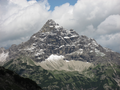
 The summit of Hochvogel the foghorn from |
||
| height | 2592 m above sea level A. | |
| location | Border Tyrol , Austria / Bavaria , Germany | |
| Mountains | Hochvogel and Rosszahn group , Allgäu Alps | |
| Dominance | 5.4 km → Urbeleskarspitze | |
| Notch height | 572 m ↓ Hornbachjoch | |
| Coordinates | 47 ° 22 '52 " N , 10 ° 26' 14" E | |
|
||
| Type | Rock peaks | |
| rock | Main dolomite | |
| Age of the rock | Triad | |
| First ascent | 1832 by Trobitius | |
| Normal way | Bad Hindelang - Prinz-Luitpold-Haus - Hochvogel | |

The Hochvogel is a 2592 m high mountain in the Allgäu Alps . The border between Germany and Austria runs over its summit . Although only the thirteenth highest peak in the Allgäu Alps, the Hochvogel dominates large parts of the Allgäu Alps and the immediately neighboring mountain groups. This is because most of the higher peaks are concentrated in the central and western part of the Allgäu Alps. The Hochvogel stands free in the eastern part of the mountain group, the nearest peaks are 200 to 300 meters lower.
Experienced mountaineers can climb the summit on two marked routes.
Rock and structure
The Hochvogel consists of main dolomite . The highest and most distinctive mountains in the Allgäu Alps are all made of main dolomite. Tectonically, the Hochvogel with the main dolomite belongs to the so-called Lech Valley Nappa. These rock packages were pushed over younger rock layers during the unfolding of the Alps. The main dolomite is partly brittle, but in interaction with the erosive forces it sometimes forms distinctive summit shapes.

The hut chronicle of the Prinz-Luitpold-Haus reports on a massive rock fall on May 27, 1935, in which thousands of cubic meters of rock fell from the southwest face into the valley. Further rock falls occurred in 2005, 2007 and 2016, the latter on the order of several thousand cubic meters of rock. The column in the summit area, which has been known for over 50 years, increased in thickness in summer 2014. During a check by the Tyrolean regional geologist in September 2014, the crevice, which is already over two meters wide in the upper area, was estimated to be a hundred meters deep. Due to the acute risk of rockslides, the ascent via Bäumenheimer Weg was then officially closed because it is in the potential demolition area. In autumn 2018, the gap had widened again (since the last inspection in summer 2014) by 30 cm. Therefore new measuring devices were installed. There is a possibility that the affected rock area of a total of 260,000 cubic meters could soon slide and fall south to the valley without endangering human settlements. Permafrost expert Michael Krautblatter from the Technical University of Munich is in charge of the measurements at the crevice. In a television documentary by ARD , he rated the increased dynamics in autumn and winter 2018 with several millimeters of movement per month as an indication that there may be another rock fall on the Hochvogel in 2019 [out of date] .
Ascension story
In the older editions of the Alpine Club Guide Allgäu Alps, an early ascent of the mountain is assumed. One of the most remarkable tourist climbs was when Hermann von Barth crossed the mountain .
Hermann von Barth stayed at the summit in 1869. On July 19 of the year he started in the morning in Sonthofen and reached - exclusively on foot - Hinterstein, where he continued after a lunch break at 12 noon. Via the Bärgündlealpe, the Balkenscharte and the Kalten Winkel, he reached the summit of the Hochvogel around 8 p.m. The next day he descended south on the east side of the south-south-west ridge into the Rosskar and on to Hinterhornbach . On that day he came to the mouth of the Schwarzwasserbach in the Lech, where he spent the night in an abandoned alpine hut. The next day he hiked via Weißenbach and the Gaichtpass to Nesselwängle, pushed another ascent of the Aggenstein and spent the night in Schattwald . On the fourth day of his violent tour he was back in Sonthofen early in the morning.
natural reserve
The side of the Hochvogel in Germany, including the neighboring mountains and high valleys, is located in the Allgäu High Alps nature reserve . On the Austrian side there is no protected area in the immediate vicinity of the peaks. The valley floor of the Hornbachtal, which borders the Hochvogel in the south, was declared a nature reserve and park Tiroler Lech on December 1, 2004 together with large parts of the Lech valley and its side valleys . It has a size of 41.38 km².
Alpinism
Valley locations / bases
Hinterhornbach is the valley town on the south side (Austria, state of Tyrol). Hinterstein is the valley town on the north side (Germany, Free State of Bavaria). The approach routes from the two valley locations are very different. Hinterhornbach is located directly at the foot of the Hochvogel, the summit - of course not with its front side - can be seen from the location. Hinterstein is located relatively far out of the valley. The Hochvogel cannot be seen from Hinterstein or from the neighboring valleys.
On the German side there is a base with the Prinz-Luitpold-Haus of the German Alpine Club. The Prinz-Luitpold-Haus can be reached from Hinterstein on the road closed to public motor vehicle traffic to the Giebelhaus (bus service), then on the farm road to the Bärgündletal and on the Alpine Club path to the hut.
Ascent
The ascent of the Hochvogel is a mountain tour with a few climbing spots (I). The normal route leads from the Prinz-Luitpold-Haus (1846 m) in 2½ hours over the Balkenscharte and the snow field of the Kalten Winkel to the summit. In early summer, you should bring crampons or grödel with you to climb the said snowfield . The Kalte Winkel can be bypassed by a partially secured path over the Kreuzspitze, which joins the route from the Prinz-Luitpold-Haus above the snow field. From the south, the somewhat more demanding Bäumenheimer Weg , starting in Hinterhornbach in the Lech Valley , led to the summit in 4½ hours.
On September 25, 2014, Bäumenheimer Weg was officially closed due to the acute risk of rockslides. The Donauwörth Alpine Club section, which is responsible for the route, indicates the closure on its website and on the local signs. The path is now beginning to run wild and a new opening is not expected at the moment. The ascent of the Hochvogel from Hinterhornbach is now only possible via the Fuchssattel and the Kalten Winkel.
The older editions of the Alpine Club leader Allgäu Alps also seen some climbing routes. These are:
- West pillar, difficulty level IV +
- South-west face, difficulty level III – IV
- Northeast face, difficulty level IV + –VI−
- North pillar, difficulty III
- Hochvogel east shoulder, north face, difficulty level IV + –VI
- Hochvogel north-west shoulder, south-west ridge, difficulty level IV
- East-northeast ridge, level of difficulty III
- South-east face, difficulty level IV – VI
From the 16th edition of the Alpine Club Guide , only routes up to difficulty level II are included. This means that only the two normal routes to the Hochvogel are described in the literature today. However , in 2006 the DAV section Allgäu-Immenstadt presented a DAV hut guide to the Prinz-Luitpold-Haus, who presented the four current climbing routes on the north side of the Hochvogel in a new photo and described and rated them with texts.
In the age of sport climbing, the climbing routes on the Hochvogel, which are characterized by fragile rock and long approaches, are hardly used any more.
view
The view encompasses many peaks of the Allgäu Alps as well as the neighboring Lechtal Alps to the south . In the east the view extends over further chains of the Northern Limestone Alps to the Wetterstein and Karwendel . In the south the central alpine ridge is open from the Hohe Tauern over the Zillertal , Stubai and Ötztal Alps to the Silvretta and the Albula mountains . In the west you can see the Swiss Alps with the Alpstein ( Säntis ) and the Glarner Alps ( Tödi ). To the north, the view extends far over the Swabian Alpine foothills to the Black Forest and the Swabian Alb . The chances of good visibility are better in autumn and winter than in spring and summer.
Plane crash
On December 14, 1945, an American B-17 , a four-engine bomber, also known as the Flying Fortress , crashed on the western flank of the Hochvogel . The machine came from Belgium and actually wanted to land at the Lechfeld base . All six crew members died in the accident; their remains could only be recovered months later due to the location on a steep slope and massive amounts of snow.
According to the American Air Force , the accident was due to a navigation error that led the machine into a snow storm. The wreck of the machine was dismantled and transported away in the 1950s.
Others
The mountain is named after the Hochvogel Munich ski club .
photos

The high bird from Knittelkarspitze from

North view from the Jubiläumsweg

South view with Kaufbeurer house and Hornbachtal
South-facing summit structure from the Kaufbeurer house

From Hinterhornbach

Northwest view from Riedbergerhorn from

from the Nebelhorn


Literature / maps
- Allgäu Alps. (Alpine Club Guide). 9th edition. Bergverlag Rother , 1974, ISBN 3-7633-1101-7 .
- Allgäu and Ammergau Alps with Tannheim mountains. (Alpine Club Guide alpine). 18th edition. Bergverlag Rother, 2013, ISBN 3-7633-1126-2 .
- Allgäuer-Lechtal Alps - East. 2/2 (Alpine Club card). 1: 25000 7th edition. 2002, ISBN 3-928777-14-9 .
- Summit destinations in the Allgäu Alps. Bruckmann Verlag, Munich 1987, ISBN 3-7654-2095-6 .
- Kristian Rath, Tobias Burger: Prinz-Luitpold-Haus DAV hut guide - hiking, climbing, adventures around the Hochvogel. SL-Verlag, Kempten 2006, ISBN 3-9810320-2-0 .
- Gustav and Georg Dinger: Hinterhornbach natural and cultural hiking guides. ed. vd Section Donauwörth d. German Alpine Club. Verlag Ludwig Auer, 2002, ISBN 3-9807169-6-1 .
- Hermann von Barth: Lonely mountain trips. Albert Langen Verlag, Munich approx. 1925, DNB 578807149 . (In it the description of the above-mentioned summit crossing)
Web links
- Prince Luitpold House. German Alpine Association Section Allgäu-Immenstadt
- H. Wessels: Hochvogel. In: kraxl.de. July 10, 2015 (tour description).
- Christian Rost: A landslide threatens to be announced in the Allgäu. In: Süddeutsche.de . November 8, 2018 .
- Uli Blumenthal: Allgäu Alps - "Rock fall in several phases": Michael Krautblatter in conversation. In: Deutschlandfunk broadcast “Research Current”. October 17, 2019 (also as mp3 audio , 7.8 MB, 8:28 minutes).
Individual evidence
- ↑ Geological map of Bavaria with explanations (1: 500,000). Bavarian Geological State Office, 1998.
- ↑ a b Helmut Mittermayr: The Hochvogel throws entire “high-rise buildings”. In: Tiroler Tageszeitung Online . November 4, 2016, accessed October 18, 2019 .
- ↑ Helmut Mittermayr: The Hochvogel takes off. In: Tiroler Tageszeitung Online. October 1, 2014, accessed October 18, 2019 .
- ↑ Stephanie Geiger: Riss im Hochvogel: A question of time before it crashes. In: FAZ.net . November 13, 2018, accessed October 18, 2019 .
- ↑ Uli Blumenthal: Allgäu Alps - "Rock fall in several phases": Michael Krautblatter in conversation. In: Deutschlandfunk broadcast “Research Current”. October 17, 2019, accessed on November 8, 2018 (also as mp3 audio , 7.8 MB, 8:28 minutes).
- ↑ Thomas Aders, Wolfgang Wanner: The story in the first: Alpendämmerung - Europe without a glacier. In: daserste.de. January 15, 2019, accessed on October 18, 2019 (film, 43:18 minutes, available until January 14, 2020).
- ↑ Stefan Roesch: Blocking off Bäumenheimer Weg. DAV section Donauwörth, accessed on October 18, 2018 .
- ↑ Hochvogel plane crash. In: Alpine Wanderpfa.de. July 2013, accessed October 27, 2018 .