Tiefenbach (Rems)
|
Tiefenbach main line upper course: Höllbach, also called: Gießbach |
||
|
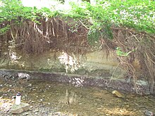
The Tiefenbach, with the ford of the Hölltalweg, view downwards |
||
| Data | ||
| Water code | DE : 23836514 | |
| location |
Foreland of the eastern Swabian Alb
|
|
| River system | Rhine | |
| Drain over | Rems → Neckar → Rhine → North Sea | |
| origin | Confluence of Höllbach and Felbenbach west of Straßdorf 48 ° 46 ′ 26.44 ″ N , 9 ° 46 ′ 4.12 ″ E |
|
| Source height | 332.5 m above sea level NN | |
| muzzle | west of Schwäbisch Gmünd in the Rems Coordinates: 48 ° 47 '7.39 " N , 9 ° 45' 25.27" E 48 ° 47 '7.39 " N , 9 ° 45' 25.27" E |
|
| Mouth height | approx. 300 m above sea level NN | |
| Height difference | approx. 32.5 m | |
| Bottom slope | approx. 19 ‰ | |
| length | 1.7 km (with Höllbach 4.3 km) | |
The Tiefenbach is an almost two, together with its left main branch source branch Höllbach a good four kilometers long left tributary of the Rems a little below Schwäbisch Gmünd in the Ostalbkreis in eastern Baden-Württemberg .
course

The Tiefenbach arises from the confluence of Höllbach and Felbenbach between the forest areas of Katharinenwald in the west and Neidling in the east, 2 km west of Straßdorf . Both spring branches arise on the northern slope of the Rechberg , the longer Höllbach is considered to be the main upper course of the Tiefenbach. The combined stream then flows through the initially wooded Hölltal towards the north and passes a sports shooting range. A little later the valley floor opens into a 100 m wide, long meadow. The brook turns to the northwest and finally flows into the Rems from the left on the southwest edge of Schwäbisch Gmünd and about 250 m above the Rems bridge of the B 29 .
Catchment area
In its forest and floodplain valley, three half-kilometer sloping streams flow into the water from the Katharinenwald in the west, none from the envious from the east. Here in the east near the Rems tributary Deutenbach competes , further to the south east, partly already beyond the Rechberg, there are small tributaries of the Waldstetter Bach , which flows further up in Schwäbisch Gmünd over the Josefsbach into the Rems. Further to the south, beyond the ridge, tributaries drain the Lauter , in the west the Tannbach in turn to the Rems, which runs from east to west in the north of the Tiefenbach catchment area.
See also
Individual evidence
- ↑ Entry on TK25, could also refer to a fork in the field very close by.
- ↑ Estimated from the contour map on the TK25.
- ↑ After the geodata viewer, see the web links
literature
- TK25: Topographic map 1: 25,000 Baden-Württemberg North, as single sheet no.7224
Web links
- Course and catchment area of the Tiefenbach on: State Institute for the Environment Baden-Württemberg (LUBW) ( information )
-
Geoportal Baden-Württemberg ( information ) with the theme map / layer
-
LUBW (State Institute for the Environment, Measurements and Nature Conservation Baden-Württemberg)
- River 1: 10,000
-
LUBW (State Institute for the Environment, Measurements and Nature Conservation Baden-Württemberg)
