Höllbach (Tiefenbach)
| Höllbach | ||
|
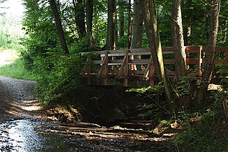
The Höllbach heading north, shortly before the confluence with the Felbenbach |
||
| Data | ||
| Water code | DE : 23836514 | |
| location | Baden-Württemberg | |
| River system | Rhine | |
| Drain over | Tiefenbach → Rems → Neckar → Rhine → North Sea | |
| source | northwest of Schwäbisch Gmünd - Rechberg 48 ° 45 ′ 24 ″ N , 9 ° 46 ′ 35 ″ E |
|
| Source height | approx. 510 m above sea level NN | |
| confluence | with the Felbenbach west of Straßdorf Coordinates: 48 ° 46 '26.44 " N , 9 ° 46' 4.12" E 48 ° 46 '26.44 " N , 9 ° 46' 4.12" E |
|
| Mouth height | 332.5 m above sea level NN | |
| Height difference | approx. 177.5 m | |
| Bottom slope | approx. 68 ‰ | |
| length | 2.6 km | |
The Höllbach is the left source brook of the Tiefenbach in eastern Baden-Württemberg . It is often seen as the upper reaches of the Tiefenbach .
course
The Höllbach rises in two spring branches at a height of approx. 500 m in a forest area northwest of Schwäbisch Gmünd - Rechberg . It first flows through a wooded area in a north-westerly direction, crosses under the L 1075 , then turns northwards, flows through the Bodenhölzle , then changes its direction to the north-east and finally joins the Felbenbach coming from the south-east to form the Tiefenbach.
swell
- TK25: Topographic map 1: 25,000 Baden-Württemberg North, as single sheet no.7224
Individual evidence
- ↑ According to GDI-BW, see the web links
Web links
Geoportal Baden-Württemberg ( information )
-
LUBW (State Institute for the Environment, Measurements and Nature Conservation Baden-Württemberg)
- River 1: 10,000
