Chemnitz-Sonnenberg
|
Sonnenberg district and statistical district No. 21 of Chemnitz |
|
|---|---|
| Coordinates | 50 ° 50 '8 " N , 12 ° 56' 24" E |
| surface | 2.24 km² |
| Residents | 14,248 (Dec. 31, 2013) |
| Population density | 6361 inhabitants / km² |
| Post Code | 09126, 09127, 09130 |
| prefix | 0371 |
| Transport links | |
| Federal road |
|
| tram | 5 |
| bus | 21, 31, 51, S91, N12 |
The Sonnenberg is a district of Chemnitz . It is named after the elevation of the same name (345.3 m) on which the district extends. It encompasses a large, closed quarter in predominantly perimeter block development , which was created between the Wilhelminian era and the First World War . The districts of Hilbersdorf , Yorckgebiet , Gablenz , Lutherviertel and the city center border the Sonnenberg . The “ Stadion an der Gellertstrasse ” and the small “Planitzwiese industrial estate” are located in this district . The most famous structures include u. a. the Markuskirche on Körnerplatz and the Wissmannhof .
history

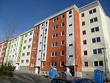
With the purchase of a western part of the monastery village of Gablenz in 1402, this area was transferred to the city of Chemnitz. This created a rural bridge between the city and the Zeisigwald, which already belongs to it . For many centuries this area, which originally only reached to today's Zietenstrasse in the east , was pastureland. It was only with the rapid increase in Chemnitz's population that the Sonnenberg began to be cultivated in the 1860s. There were planned, chessboard-like streets, on which tenements were built, and Hilbersdorf porphyry was also used in their construction . At Theodor-Körner-Platz , where the Körner memorial was located until 1945, the Protestant St. Mark's Church was built between 1892 and 1895. Not far from there was the Catholic St. Joseph Church on Alexanderstraße (today Ludwig-Kirsch-Straße ) from 1907 to 1909 . On Planitzstrasse (later Leninstrasse , today Heinrich-Schütz-Strasse ), the “15th Royal Saxon Regiment No. 181 “a barracks was built not far from the Zeisigwald. This was used by the Soviet Army in the GDR era - today it has been torn down except for the three listed buildings. In the mid-1980s, numerous old buildings in the southern part of the Sonnenberg, some of which had already decayed, were replaced by prefabricated houses. After 1990 the Sonnenberg was declared an area monument due to its old building substance. Nevertheless, buildings with old buildings are still being demolished to a large extent, which has met with criticism from numerous residents and experts. These dismantling measures carried out as part of the “Urban Redevelopment East” are intended to counteract the high vacancy rate caused by the enormous decline in population that Chemnitz has experienced since reunification.
Historic Buildings
In the extreme south-east of the district there is an architectural and historical landmark: the Wissmannhof . This residential courtyard, named after Hermann von Wissmann , from the 1920s impresses with its unusual architecture for a multi-storey apartment building. The residential complex was built according to the designs of the Chemnitz architect Curt at the end . In the Wissmannhof, interestingly designed facades, well-tended green spaces and a well thought-out system of paths harmonize with one another.
traffic
The Sonnenberg can be reached with the bus lines 21, 31, 51, 82, S91 and N12 of the night network as well as with the tram line 5. Until February 21, 1972 the tram line 7 drove over the August-Bebelstraße and Palmstraße , past the tram depot to Leninstraße Terminal Leninstrasse (today Heinrich-Schütz-Strasse ) at the confluence of Zeisigwaldstrasse . Furthermore, the Sonnenberg was used by tram line 8 via Dresdner Strasse , Sonnenstrasse and Hainstrasse until December 20, 1975 . The tram depot on Leninstrasse was closed on January 5, 1976 and later used as the main bus workshop. After the fall of the Wall, it housed a go-kart track and a fan meeting place for CFC fans until 2013. At the beginning of 2014, the tram depot was demolished as part of the new construction of the stadium on Gellertstrasse. Important arterial roads are Hainstrasse and Zietenstrasse from north to south and Fürstenstrasse from east to west .
Aerial photography
See also
literature
- Authors group of the working group Sonnenberg-Geschichte Chemnitz: The sun gave the name. Chemnitz 2008, ISBN 978-3-936241-10-5 .


