Holy way
The Holy Way was created as part of the canonization of Bishop Benno von Meißen . It led from Bohemia to Meißen and ran between Grillenburg and Wilsdruff in the district of Saxon Switzerland-Eastern Ore Mountains in the opposite direction, parallel to the Saxon Way of St. James . An original section remained u. a. preserved in the Tharandt forest between Grillenburg and Spechtshausen .


Origin and course
After the bones of Bishop Benno (* around 1010 in Hildesheim ; † June 16, 1106 in Meißen) were found during the reconstruction of the cathedral (from 1260) in Meißen and raised around 1270, it lasted until the bishop's canonization (1524) and the transfer of the bones from 1539 via Stolpen and Wurzen to Munich ( Frauenkirche , patron saint of Munich) , a pilgrimage route in the course of the Reformation in the Electorate of Saxony . It came from Bohemia over the Erzgebirge ridge and led via Frauenstein (cemetery chapel - former town church), Reichstädt (former Kahlehöhenkirche ), Dippoldiswalde ( prayer pillars , partly Romanesque town church and Nikolaikirche at the cemetery), Berreuth , Ruppendorf (prayer column), Höckendorf (Romanesque village church), the Markgrafenstein (medieval watchpoint of Tharandt Castle near Warnsdorf ), Grillenburg , Spechtshausen , Fördergersdorf (Romanesque village church with murals), Grumbach (village church of Romanesque origin), Wilsdruff (once one of the oldest bells in Saxony with a so-called Benno bell in the Jakobikirche ) to Meissen. In Meißen one got through the Martinskapelle (around 1200) on the Plossen , the Nikolaikapelle (1220) in the Triebischtal and the Augustinian canon monastery of St. Afra (around 1220) to the sanctuary in the Meißner Dom on the Burgberg .
Between Grillenburg (presumed pilgrims' hospice ) and Wilsdruff ( Jakobikirche ) the route should have been identical to the Meissnian-Franconian way of the pilgrims in the course of the Alte Frankenstrasse . This probably branched off from the Via Regia near Königsbrück or Grossenhain , ran from the Elbfurt near Constappel ( pilgrimage church St. Nikolaus ), via the Gohlberg (presumed castle warden) and the Hühndorfer Höhe , to Wilsdruff ( Jakobikirche ), met the saint there Way and left this again in Grillenburg (presumed pilgrim hospice) towards Freiberg .
history
In Grillenburg, the Riesenburger Weg or the Alte Meißner Landstrasse (also Längenweg , Langer Weg ) crossed from Meißen over the Ore Mountains Pass at Dlouhá Louka / Langewiese to Rýzmburk / Riesenburg near Osek / Ossegg, and the Hohe Strasse from Dohna by Weißeritz - Wade in Potschappel to Freiberg . The castle Pohrsdorf at the beginning of today's Kirchweg in the Oberdorf as well as the guard points Kienberg, Markgrafenstein and Borschelberg (also Burgstadl ) with the place Warnsdorf in the Tharandt forest served to protect the pilgrimage routes . Since the Hussites also used these routes during their invasion in 1429/30 and Bohemian mercenaries in the Fraternal Wars in 1450, at the latest during this time u. a. the Markgrafenstein watchpoint, the pilgrims' hospice in Grillenburg, Pohrsdorf Castle and the Fördergersdorf church destroyed. The Castle Tharandt attacked the Hussites at what is proved by archeological studies, and the city Wilsdruff burned during the war 1450th
Later use
One of the last prominent pilgrims on the Saxon Way of St. James, now running from Bautzen via Dresden in the course of the Frankenstrasse, was Heinrich the Pious in 1503 , under whom the Reformation entered Saxony as Duke of Saxony in 1539.
After the Reformation, the paths connected with the construction of the Grillenburg hunting lodge on the walls of the presumed pilgrims' hospice (1554–58) and the like remained. a. preserved as hunting trails and connection to the official villages. Because Grillenburg became the seat of the office, the judicial authority and the chief forest and game master.
The pilgrimage route between Fördergersdorf and Grillenburg was marked with a forest sign from the end of the 16th century to the 18th century that represents a W with a star above it. It connected Dresden with Grillenburg under the name Fürstenweg or Herrenweg and continued via Freiberg to Augustusburg near Flöha . As a so-called corpse path or elector path , it is also used for the funeral processions of the Protestant Wettins from Dresden to the cathedral in Freiberg , for example on September 11, 1691 for Elector Georg III. (Burial: December 11, 1691) and on April 27, 1694 for Elector George IV. (Burial: July 5, 1694).
The pilgrimage route between Grillenburg and Dippoldiswalde has survived as a sacred route between these stately official and hunting seats and was marked with the symbol of a deer antler. A path near Höckendorf still bears this name today .
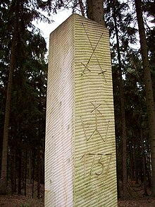
In 1737, instead of post mile columns and dilapidated wooden columns, sandstone hunting columns were erected on the Fürstenweg or Herrenweg between Dresden and Grillenburg . In contrast to the hunting pillars of the Dresden enclosure from the 17th century that have survived to this day, among others in Braunsdorf , Kesselsdorf and Kleinopitz , among the course swords were the path marking W with a star above it and the year 1737, which is otherwise a forest sign in the trees chiseled in. Replicas according to historical descriptions were set up in Fördergersdorf and in the Tharandt forest .
It was not until the checkerboard-like, straight aisles and wing system introduced by Heinrich Cotta in the Tharandt forest in 1811 that numerous historical paths, as well as the pilgrimage and hunting paths, whose course can only be guessed through deep ditches in the area, were replaced.
Rededication
On May 18, 2003, after a joint church service by the parishes of Fördergersdorf and Tharandt in Kurort Hartha as part of the hike on the paths of songs with the choir of Kurort Hartha eV, a Tharandt Teaching Forestry Office (today: Bärenfels Forest District ) led by the district forester Dirk Junkuhn's reconstructed historical pilgrimage and hunting route presented to the public.
It is a very deep ravine on the Ascherhübel in the Tharandt forest , which runs parallel to the Mühlweg between Spechtshausen and the Ernemann refuge in the Triebischtal , where the hiker will find a wooden pilgrim's cross and a sandstone hunting column as well as path markings carved into the trees . The pilgrim cross in the Tharandt Forest was designed based on a historical model, which was preserved on the border with Bohemia near Fürstenwalde as the so-called Black Cross ( Alte Dresden-Teplitzer Poststrasse ).
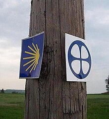
Following the ecumenical pilgrimage project , supervised by the ev.-luth. The State Youth Parish Office of Saxony , which focuses on the way of the Jakobspilgrims in the course of the Via Regia with free pilgrim hostels, became the pilgrim path in the Tharandt Forest under the leadership of the Association Sächsischer Jakobsweg on the Frankenstraße , as part of the connections from the Via Regia ( Königsbrück or Bautzen ) to the paths of the St. James pilgrims in Franconia ( Hof ), newly marked and can thus regain national significance. The marking and first ascent of the Saxon Way of St. James in the Tharandt Forest was carried out in 2011 and in the Wilsdruffer Land with the inauguration on May 17, 2012. There are pilgrims' hostels at the Tharandt Forest in the vicarage Fördergersdorf and in the Naundorf youth camp . Stamp stations were set up in the parsonage Fördergersdorf and at the Waldhof inn in Grillenburg .
A cross-border hiking and pilgrimage route, which does not identify with the Holy Way , exists without any waymarking between Mariánské Radčice / Maria Ratschitz and Osek / Ossegg ( Bohemia ) and Rechenberg .
Between Frauenstein and Grumbach , via Dippoldiswalde and through the Tharandt forest , as well as through Klipphausen to Meißen, the holy path is already marked and in the future it will gradually be shown continuously at least between Frauenstein and Meißen and can be experienced again via already existing marked hiking trails from the Osek monastery to the Meißner cathedral become. It is already completely accessible. The path conditions and signage or markings are not yet of sufficient quality for a hiking recommendation for the entire path.
The house of silence at the ev.-luth. Parish office Grumbach with pilgrims' hostel and the ev.-luth's home for the preparation period. Stadtjugendpfarramtes Dresden Our hut in the health resort Hartha and the Jakobikirche in Wilsdruff , which is supported by the Stiftung Leben und Arbeit as a motorway church , can already be easily connected to it.
Marking of the Mariánské Radčice / Maria Ratschitz pilgrimage route → Rechenberg
Marking Heiliger Weg Rechenberg → Meißen
Marking the Saxon Way of St. James, Königsbrück or Bautzen → Hof
Marking the way of the pilgrims to the Saxon Way of St. James (including Meißen → Klipphausen )
Stamp Sächsischer Jakobsweg - Station Grillenburg in the Tharandt forest
Stamp Sächsischer Jakobsweg - Station church Fördergersdorf am Tharandter Wald
swell
- H. Wiechel: The oldest ways in Saxony. Ore Mountains Museum Annaberg-Buchholz , V10 / 2
- Kurt Osk. Clay: from the past and present of the villages of Hartha, Grillenburg, Fördergersdorf, Hintergersdorf, Spechtshausen and Porsdorf near Tharandt. Self-published by the author in 1904
- Walter Bachmann : Grillenburg. Communications of the Landesverein Sächsischer Heimatschutz, Issue 5–8, Volume XXV, Dresden 1936
- Kulturbund der DDR , Ortsgruppe Tharandt (Ed.): Der Tharandter Wald, Forststadt Tharandt, Contributions to Heimatgeschichte, Issue 7, Tharandt 1982
- Heinz Weise (Ed.): Mark Meißen . FA Brockhaus Verlag, Leipzig , 1st edition 1989
- Heinrich Magirius , Norbert Oelsner , Reinhard Spehr : Grillenburg. State Office for Monument Preservation Saxony, workbook 10, Dresden 2006, ISBN 978-3-937602-85-1
literature
- Renate Rettig: The Jakobspilgerweg in the Tharandt forest ... , Friends of the tourist guide Tharandter Wald-Osterzgebirge eV (ed.), Kurort Hartha 2010
- Historical pilgrimage and hunting trail in the Tharandt forest , André Kaiser
- Stephan Klingbeil: Pilgrims' paths should stimulate tourism. Sächsische Zeitung Freital, February 9, 2011, p. 14
- Peter Hertel: The shell shows pilgrims the way. Freie Presse Freiberg, July 2, 2011, p. 10
- Peter Hertel: Hikers walk on a sacred path. Free Press Freiberg, July 5, 2011
- Iris Schmidt: Make a pilgrimage in the spirit of the shell. Freitaler Wochenkurier, July 20, 2011, p. 2
- Ines Klein: On the way to yourself. Sächsische Zeitung Freital, July 26, 2011, p. 14
- Astrid Ring: On the pilgrimage to Bohemia. Free Press Freiberg, August 26, 2011
- Renate Rettig: The Saxon Way of St. James and the Holy Way in the Tharandt Forest ... , Tourist Guide Erzgebirge eV (Ed.), Kurort Hartha 2013 and 2015
- Franz Herz: New signs surprise in Dipps ... , Sächsische Zeitung Dippoldiswalde, July 20, 2017
Web links
- Ecumenical pilgrimage along the Via Regia in Saxony and Thuringia
- Way of the Jakobspilger in the course of the Frankenstrasse in Saxony
- Hiking and pilgrimage route of the HGV Rechenberg-Bienenmühle eV
- Way of St. James in Saxony
- Network Old Salt Road in Saxony
- Historical paths over the Eastern Ore Mountains as part of the Holy Path
- In the footsteps of Bishop Benno
- Hiking recommendation with current information
Coordinates: 50 ° 58 ′ 44.5 ″ N , 13 ° 31 ′ 40.4 ″ E


