Constappel
|
Constappel
Community Klipphausen
Coordinates: 51 ° 6 ′ 20 ″ N , 13 ° 34 ′ 0 ″ E
|
|
|---|---|
| Height : | 117 m |
| Incorporation : | 1923 |
| Incorporated into: | Gauernitz |
| Postal code : | 01665 |
| Area code : | 0351 |
|
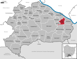
Location of the Constappel district in Klipphausen
|
|
Constappel is a district of the village of Gauernitz in the municipality of Klipphausen in the district of Meißen , Saxony .
geography
Constappel is located between Meissen and Dresden on the edge of the Meissen highlands . Nearby (on Gauernitzer hallway) opens from Wilsdruff coming Wilde Sau in the same , the village itself is located on Saubach. On the other side of the Elbe is the Coswig district of Kötitz . Federal highway 6 runs through Constappel and connects it with the neighboring towns of Wildberg in the east and Gauernitz in the north-west. To the west and southwest of Constappel, Pinkowitz and Hartha are the remaining parts of the village of Gauernitz. The neighboring Kleinschönberg to the south and Weistropp to the south-east belong to the village of Klipphausen.
history
After the final submission of the Daleminzier in 928/929, King Henry I built Meissen Castle . After he had conquered the areas to the left of the Elbe, he set up three keepers as security . These are mentioned in a document in 1071. A castle keeper is believed to be on the 237 m high Gohlberg near Constappel.
In the year 1000 the Parish Constappel was founded in the valleys to the left of the Elbe . It lay in the border area between the Slavic Gau (pagi) Daleminzien and Nisan , which probably corresponded roughly to the course of the Wild Sau . The church in Constappel was already a pilgrimage church in the 11th century. The old trade route from Meissen to Dresden did not lead along the Elbe, but along the heights. It was crossed by the Meissnian-Franconian way of the Jakobspilger , west of the nearby Elbfurt.
Constappel was first mentioned in a document in 1334 as "Kuntopel". The village was administered by the Meissen Hereditary Authority . The manorial rule was exercised by the lords of the Gauernitz manor . In 1900, the loose, space-like farmer hamlet had a 149-hectare block corridor . Constappel has been the location of a parish church since the Middle Ages , the parish of which extended over the surrounding towns. A Vorwerk is mentioned in 1454 and again in 1875, and in 1933 the Saxon automobile pioneer Emil Nacke was buried in Constappel.
In 1923, which took place annexation of the neighboring village Gauernitz in the Kirchdorf Constappel. Since Gauernitz already had more inhabitants at that time, the rural community of Constappel was renamed Gauernitz five years later . As part of this earlier municipality, which like Scharfenberg has the status of a locality , Constappel came to the municipality of Klipphausen on January 1, 1999 .
Population development
|
St. Nicholas Church
The St. Nicholas Church in Constappel, already mentioned in a document at the end of the 14th century, is one of the oldest churches in the Meißner Land today. In the Middle Ages it was a pilgrimage church for a long time. On the pilgrimage days of Pope Innocent VI. in Avignon in 1358 issued a letter of indulgence on a red velvet cushion that promised 40 days of indulgence to anyone who brings a gift on the day of grace. The church has valuable interiors and various art treasures, such as a painting from the school of Lucas Cranach the Elder. Ä. It was fundamentally renewed at the end of the 19th century.
In addition, other buildings in the village are protected as cultural monuments (see list of cultural monuments in Gauernitz ).
→ see also Holy Way
Others
The starting point of the first Stoppomat system in the new federal states is in Constappel . It is set up on the mountain route from Constappel to Kleinschönberg , on which a height difference of 182 meters has to be overcome over a route length of 4520 meters. The operator is the cycling department of the Elbland Coswig-Meißen e. V.
photos
View over the Elbe to Constappel to the Elbschlösschen
literature
- Constappel . In: August Schumann : Complete State, Post and Newspaper Lexicon of Saxony. 5th volume. Schumann, Zwickau 1818, p. 77.
- A. Kühne / A. Ranft: History and stories in and around Wilsdruff - A home book for the Wilsdruffer Land , association for natural and local history (ed.), Wilsdruff 1930/1931; here: Reprint of the Landesverein Sächsischer Heimatschutz eV, local group Wilsdruff (ed.), Meißner Tageblatt Verlags GmbH, Wilsdruffer Tageblatt 1994, ISBN 3-929705-01-X , p. 104.
- Cornelius Gurlitt : Constappel. In: Descriptive representation of the older architectural and art monuments of the Kingdom of Saxony. 41. Issue: Administrative Authority Meißen-Land . CC Meinhold, Dresden 1923, p. 106.
Web links
- Constappel in the Digital Historical Directory of Saxony
- St. Nikolai Church in Constappel
Individual evidence
- ↑ StBA: Changes in the municipalities in Germany, see 1999
- ↑ gps-tour.info
- ↑ Constappler Stoppomat is very popular. (PDF, 1.2 MB, p. 9) (No longer available online.) In: Landpost. June 2010, archived from the original on September 16, 2012 ; Retrieved October 22, 2013 . Info: The archive link was inserted automatically and has not yet been checked. Please check the original and archive link according to the instructions and then remove this notice.


