Kettewitz
|
Kettewitz
Community Klipphausen
Coordinates: 51 ° 6 ′ 35 ″ N , 13 ° 26 ′ 35 ″ E
|
|
|---|---|
| Height : | 210 m above sea level NN |
| Residents : | 34 (Dec 31, 2011) |
| Incorporation : | April 1, 1938 |
| Incorporated into: | Sonitz |
| Postal code : | 01665 |
| Area code : | 035245 |
|
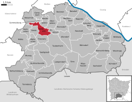
Location of the Kettewitz district in Klipphausen
|
|
Kettewitz is a district of the municipality of Klipphausen in the district of Meißen , Saxony .
geography

Kettewitz is located in the Meißner highlands between Wilsdruff , Nossen and Meißen . The village is surrounded by the other districts belonging to Klipphausen: Kobitzsch in the east, Taubenheim in the south-east, Piskowitz in the south, Sönitz in the south-west, Roitzschen with Roitzschwiese in the west, Robschütz in the north-west, Semmelsberg in the north, and Polenz in the north-west.
The small, rural village consisting of only five courtyards is located on the elongated hill between the valleys of the Gallenbach and the Kleine Triebisch . At the northwestern end of the ridge, high above the valley of the (Große) Triebisch near Robschütz, the Jokischberg, whose ramparts are under monument protection . There is also a hamlet consisting of two courtyards . The center of the Platzdorf , however, is a good one and a half kilometers as the crow flies southeast of the Jokischberg along the “Am Dorfteich” road. To the public transport chain joke is by the bus line 414 of the transport company Meissen connected, which leads through the chain Witzer road. The “Zur kleine Triebisch” path runs east to the Niedermühle near Kobitzsch.
history
The village was first mentioned in 1428 as "Katenwicz". The name is derived from the Old Sorbian "Chotěnovici", which in turn goes back to the locator name "Chotěn". The place name means something like "settlement of the people of a Chotěn". Over the centuries it changed, among other things, via the forms "Cottenwicz", "Kötthewitz", "Kothwitz" and "Köttewitz bey Taubenheim" to the current spelling. In the 19th century, the form "Köttewitz", which was used before the delabialization , was also in use.
The castle wall on the Jokischberg dates back to the Middle Ages, when the area was settled by Slavs . A smaller rampart is opposite it on the other side of the Triebischtal in Robschütz. The fortifications on the mountain spur, which is only accessible from the east, of which parts of the ramparts and the inner ditch have been preserved, encompass an area of considerable size with about four hectares. Archaeological surface finds have been made in this area. The name of the elevation, also popularly known as "Gucksch" or "Kokisch", can be explained with a Slavic form of Jakob, such as Jokuš. Parts of the site were used as burial grounds as early as the Bronze Age, but fortifications from this period do not exist.
Around the village of Kettewitz, whose residents earned their income from agriculture, there was a 209 hectare block and striped field . Parish was and is the village after Taubenheim. The owners of the manor there also exercised the manorial rule in Kettewitz. For centuries, the administration of the place was the responsibility of the Meissen Hereditary Authority . In 1856 Kettewitz belonged to the Meißen court office and then came to the Meißen district administration , from which the district of the same name emerged. On the basis of the rural community order of 1838 , Kettewitz gained independence as a rural community , but lost its independence on April 1, 1938 when it was incorporated into Sönitz. As part of it, Taubenheim came into being in 1974, which in turn has belonged to Triebischtal since 2004. Kettewitz has been part of the Klipphausen community since July 1, 2012.
Population development
|
Web links
- Kettewitz in the Digital Historical Directory of Saxony
- Kettewitz address book from 1905
Individual evidence
- ^ Ernst Eichler / Hans Walther : Historical book of place names of Saxony. Vol. 1, Berlin 2001. p. 481.
- ↑ Elbe valley and Loesshügelland near Meißen (= values of our homeland . Volume 32). 1st edition. Akademie Verlag, Berlin 1979, p. 188.
- ^ Michael Rademacher: German administrative history from the unification of the empire in 1871 to the reunification in 1990. City and district of Meißen. (Online material for the dissertation, Osnabrück 2006).


