
Administrative community Tharandt
| coat of arms | Germany map | |
|---|---|---|
 Help on coat of arms |
Coordinates: 50 ° 59 ′ N , 13 ° 35 ′ E |
|
| Basic data | ||
| State : | Saxony | |
| County : | Saxon Switzerland-Eastern Ore Mountains | |
| Area : | 77.47 km 2 | |
| Residents: | 6535 (Dec. 31, 2019) | |
| Population density : | 84 inhabitants per km 2 | |
| License plate : | PIR, DW, FTL, SEB | |
| Association key : | 14 6 28 5240 | |
| Association structure: | 2 municipalities | |
| Association administration address : |
Schillerstraße 5 01737 Tharandt |
|
| Administrative Chairman: | Silvio Ziesemer | |
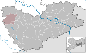
| Location of the Tharandt administrative community in the Saxon Switzerland-Eastern Ore Mountains district | ||
  |
||

The Tharandt administrative association is an administrative association in the Free State of Saxony . It is located in the northwest of the Saxon Switzerland-Eastern Ore Mountains district, about 15 km southwest of the state capital Dresden , about 20 km east of Freiberg and about 8 km northwest of the former district town of Dippoldiswalde .
The landscape of the community area is in the northernmost foothills of the Ore Mountains, in the valley of the Wild Weißeritz and in the Tharandt forest , as well as on its north and east edge. The federal highway 173 and the federal highway 4 run north of the community area and can be reached via the junction Wilsdruff . Tharandt is also on the Dresden – Werdau railway line and is connected to the Dresden S-Bahn network . However, the closest train stations to the member community of Dorfhain are Klingenberg-Colmnitz and Edle Krone , both of which are located outside the administrative community in the neighboring community of Klingenberg .
The administrative community was formally established on January 1, 2000 and has not been fully implemented since Dorfhain continues to maintain its own administration.
Member municipalities
- Tharandt and the districts of Fördergersdorf , Grillenburg , Großopitz , Kurort Hartha , Pohrsdorf , Spechtshausen and Tharandt
- Dorfhain with the districts Kleindorfhain , Mitteldorfhain and Großdorfhain
Individual evidence
- ↑ Population of the Free State of Saxony by municipalities on December 31, 2019 ( help on this ).
- ^ Administrative community Tharandt in the regional register of Saxony