
Center of Saxony
There are several central points of Saxony , which are based on different, scientific methods of calculation. These can be seen on the list of geographical centers . The main articles in the center of Germany and the center of Europe explain more about the different methods .
location
The central points in relation to today's Free State of Saxony are located in the borders from 1990 onwards
- in the Tharandt forest - in the Grillenburg district of Kurort Hartha ( Kurort Hartha - center of Saxony ), town of Tharandt , district of Saxon Switzerland-Eastern Ore Mountains
- in districts of the city of Nossen , ( Nossen - middle of Saxony ), district of Meißen
- in Altzella
- in Deutschenbora .
The midpoints with respect to the former
- Kingdom of Saxony is located in Lichtenberg / Erzgeb. near Mulda , district of central Saxony
- Saxony in the borders from 1815 to 1945 is located in Großschirma near Freiberg , district of central Saxony .
Geographic center

|
The most famous center of Saxony is the geographical center of the Free State of Saxony on the district Grillenburg of Kurort Hartha , in the Tharandt forest ( Tännichtgrund ), in front of the thief's chamber rock on the Colmnitzbach . He was founded in October 1990 by Dr. Heinz Finger, Geodät at the TU Dresden , and in 1992 by the cartographer Hans Brunner from Dresden with the coordinates 50 degrees, 55 minutes, 46.1 seconds north latitude and 13 degrees, 27 minutes and 30 seconds east longitude (mean values of the coordinates of the northernmost and southernmost, as well as the easternmost and westernmost point of the country) and an accuracy of one arc second (max. deviation 31 meters to the east and 20 meters to the north) ( 50 ° 55 ′ 46.1 ″ N , 13 ° 27 ′ 30 ″ E ). The marking by a man-high granite stele was carried out on behalf of the broadcast “ Outsiders-Front-Rider” of the MDR television on September 28, 1994 in the presence of Saxony's Minister of the Interior Heinz Eggert . The stele was made and donated by Steinmetz G. Haase from Bautzen and set up about 250 m west of the center. The stele is thus clearly outside the specified error tolerance of 31 m for the measurement, because at the time of installation it was the next suitable and accessible location due to the unfavorable terrain there that could also be developed for tourism. The actual measuring point was made accessible by the municipality of Kurort Hartha in 1995 with a bike and hiking trail on the route of the former Klingenberg-Colmnitz-Oberdittmannsdorf narrow-gauge railway that was overgrown after the closure in the Tharandt forest . The Deutsche Bahn in the form of DB Netz AG , however, due to the predominant previous use for railway purposes, was granted ownership of this railway line by the Oberfinanzdirektion Berlin upon request, so that the cycle and hiking path could only be used to a limited extent due to a lack of traffic safety and in 2017 was even blocked. On September 12, 2017, at the request of July 18, 2017, half of this cycle and hiking trail was allocated to the neighboring municipalities of Bobritzsch-Hilbersdorf and Klingenberg , which released it again on September 14, 2017. Thus, on April 25, 2018, the actual measuring point could be marked, initially with a notice board, and on July 26, 2019 with a measuring point. The way to this measuring point is signposted from the central point.
In 1995 the tourist word and image brand Kurort Hartha - the center of Saxony was registered with the European Patent Office in Munich for the municipality of Kurort Hartha (today: locality of the city of Tharandt ) and thus protected under trademark law. The neighboring town of Naundorf officially calls itself Naundorf at the center of Saxony . This center is signposted from the Kurort Hartha and Naundorf as well as shown in hiking maps and is used for annual cultural and sporting events ( cross-country run to the center of Saxony in spring, choir singing at the center of Saxony in autumn). There are also souvenirs (miniature central stele, postcards) available.
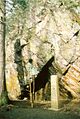
Granite stele from 1994 at the geographical center of Saxony in the Tharandt Forest

Coats of arms of Kurort Hartha since 1927 with the current brand name above the entrance to the former municipal office, now Hennig clock technical teaching show

View through the advertising and welcome board to the health resort Hartha

Information board for the measuring point on the former embankment above the central stele


The geographical center of the Kingdom of Saxony was located with the coordinates 50 degrees, 49 minutes north latitude and 13 degrees, 27.5 minutes east longitude at the Lichtenberg dam near Mulda and was also determined in 1992 by the Dresden cartographer Hans Brunner.
Physical focus
|
The physical focus of the Free State of Saxony is on Hirschfelder Weg in the Nossen district of Deutschebora . It was determined in 2009 by the state enterprise Geobasisinformation und Vermessung Sachsen (GeoSN) with the help of around 60,000 geographical points on the state border. In 1992, the cartographer Hans Brunner calculated the Siebenlehn motorway bridge on the A4 near Nossen. To mark the 825th anniversary of Nossen on 23 August 2010, the center of Saxony, calculated by the GeoSN using the focus method, was marked with a metal stele both manufactured and donated by the company Flexomat GmbH from Nossen in the presence of the Saxon state parliament president Matthias Rößler , which symbolically for this calculation method is a needle and the area of the Free State of Saxony. In 2014 thieves tried unsuccessfully to steal this stele. The exact coordinates, based on the coordinate reference system ETRS89_UTM33, are according to a board on the stele: Lat 51 ° 03 ′ 10.55 ″ N, North 5 657 014 m, Lon 13 ° 20 ′ 41.85 ″ E, East 33 384 002 m ( 51 ° 3 ′ 10.6 " N , 13 ° 20 ′ 41.8" E ). Fits to was by the artist Claudia deer from Dresden a center - sculpture created.
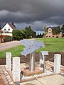
Stele at the physical focus of Saxony
Detail of the stele at the physical center of Saxony

Measuring point on the Hirschfelder Weg next to the stele


The physical focus of the Kingdom of Saxony was on a district road, a few meters west of the B 101 , in Großschirma near Freiberg. It was also determined there in 2009 by the GeoSN. The cartographer Hans Brunner determined the place Bräunsdorf an der Große Striegis near Freiberg in 1992 .
Further centers
The center of the largest (geometric) circle that fits Saxony in the boundaries of the Free State , is, according to the information provided by the cartographers Hans Brunner from the years 1993 and 2009 south of Marbach (Striegistal) , on the western edge of the cell forest , not far from the monastery Altzella on the district Altzella in the city of Nossen.
literature
- Hans Brunner: Centers and other geometric points in Saxony , communications of the Landesvereines Sächsischer Heimatschutz, Dresden, issue 3/1993, p. 33 ff., ISSN 0941-1151
- Postcards M / 669 and 16504, Verlag A. & R. Adam, Dresden
- Inscription on the miniature central stele made of sandstone, Small Saxon Switzerland show workshop, Wehlen village
- Staatsbetrieb Geobasisinformation und Vermessung Sachsen , hiking map Tharandter Wald , sheet 31 (topographic map, edition with hiking trails, 1:25 000) 3rd edition, August 2008, ISBN 978-3-86170-082-1
- André Kaiser: 75 years Kurort Hartha - place names, local coats of arms and protected advertising symbols , Around the Tharandt Forest, Official Gazette of the City of Tharandt, November 2008
- Thomas Schade: Saxony's new center , Sächsische Zeitung, Dresden February 28/1. March 2009, p. 3
- André Kaiser: The geographic center of Saxony is still in Kurort Hartha , Around the Tharandt Forest, Official Gazette of the City of Tharandt, March 2009
- Jörg Stock: Hartha stays tough: The middle is ours! , Sächsische Zeitung, Freital, May 15, 2009, p. 14
- Dieter Hanke: A stele in Nossen marks Saxony's new center , Sächsische Zeitung, Meißen, August 12, 2010
- Uwe Anke: Speech for the inauguration of the stele at the physical focus of Saxony , Nossen, 23 August 2010
- Susanne Plecher: New focus now visible , Sächsische Zeitung, Meißen, August 24, 2010
- Claudia Hübschmann: Stele stands for Saxony's new focus , Freie Presse, Freiberg, August 24, 2010, p. 9
- Markus Griese: Saxony's double center only knows winners , Morgenpost am Sonntag, Saxony, August 29, 2010, p. 6
- André Kaiser: "Kurort Hartha - Center of Saxony®" and "Nossen - Center of Saxony", geographic center and physical focus of the Free State of Saxony , Around the Tharandt Forest, Official Gazette of the City of Tharandt, September 15, 2010
- Jörg Stock: Which middle is in the middle? , Sächsische Zeitung, Freital, 18./19. September 2010, p. 20
- Dieter Hanke: Saxony's new center should become even better known , Sächsische Zeitung, Meißen, January 3, 2011
- Thieves want to steal Saxony's funds , Sächsische Zeitung, Radebeul, September 9, 2014
- André Kaiser: 20 years "Kurort Hartha - Center of Saxony®" ... , Around the Tharandt Forest, Official Gazette of the City of Tharandt, September 15, 2014
Web links
- Kurort Hartha - center of Saxony (city of Tharandt)
- Naundorf at the center of Saxony (Bobritzsch-Hilbersdorf municipality)
- Nossen - in the middle of Saxony
Individual evidence
- ^ Decision of the Federal Office for Central Services and Unresolved Property Issues, Cottbus headquarters, dated September 12, 2017
- ↑ Steffen Jankowski: Railway line remains hiking trail: Mayors tear down barriers , Freie Presse, Freiberg, September 15, 2017
Coordinates: 50 ° 55 ′ 46.1 ″ N , 13 ° 27 ′ 30 ″ E